Download
1 / 29
300 likes | 383 Views
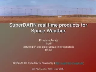
SuperDARN real time products for Space Weather. Ermanno Amata INAF Istituto di Fisica dello Spazio Interplanetario Roma. Credits to the SuperDARN community ( http://superdarn.jhuapl.edu ). Outline. SuperDARN and its principle of operation Mesospheric winds product

E N D
SuperDARN real time products for SpaceWeather Ermanno Amata INAF Istituto di FisicadelloSpazioInterplanetario Roma Credits to the SuperDARN community (http://superdarn.jhuapl.edu) ESWW5, Bruxelles, 20 November 2008.
Outline SuperDARN and its principle of operation Mesospheric winds product MUF and foF2 products Convection maps and transpolar potential drop (including the description of a couple of events) ESWW5, Bruxelles, 20 November 2008.
SuperDARN Fields of View ESWW5, Bruxelles, 20 November 2008.
HF propagation Principle of operation of SuperDARN Absorption Phase and amplitude fluctuations Refraction Back-scattering Doppler shift ESWW5, Bruxelles, 20 November 2008.
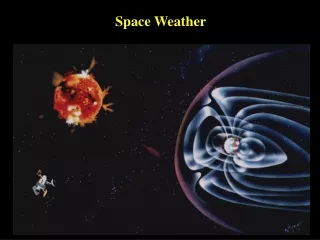
SuperDARN principle of operation Field aligned density irregularities Back-scattered HF signal: echo B Ionosphere ESWW5, Bruxelles, 20 November 2008.
Twokindsofscatter, i.efrom: ground ionosphere Bothkinds can beused: fordifferentpurposes. Even the absenceofscattercouldbeused. Milan et al., 1997 ESWW5, Bruxelles, 20 November 2008.
SuperDARN facts Almost all radars form pairs coveringroughly the same area fromdifferent directions. 16 azimuthalbinscovering 52°. 75 range gates, 45 km each. Time for full azimuth-range scan: 1-2 min. Special modes allowed: e.g. one fixedbeamwith 3 s resolution. Some radars operate in the STEREO mode (Leicester Un., UK), whichallows to sound the f-o-v attwodifferentfrequencies: e.g. full 2D scan at f1; 3s resolutionalong a single beamat f2. Monthly planning approved by all PI’s. ESWW5, Bruxelles, 20 November 2008.
One day of SuperDARN echoes ESWW5, Bruxelles, 20 November 2008.
SuperDARN and SpaceWeather Space Weather Science - Solar wind – magnetosphere coupling - Location of magnetospheric boundaries - Occurrence of radar echoes in relation with SW conditions Space Weather Real-time data products - Normal echoes Convection maps and polar cap potential (in operation) - Ground scatter HF propagation conditions (not in operation) - Near range echoes Mesospheric winds (not in operation) ESWW5, Bruxelles, 20 November 2008.
Outline SuperDARN and its principle of operation Mesospheric winds product MUF and foF2 products Convection maps and transpolar potential drop (including the description of a couple of events) ESWW5, Bruxelles, 20 November 2008.
Mesosphericwindmeasurementsfrom SuperDARN low range echoes Meteorechoesdaily rate at Halley radar in 1996 400 meteorechoes/hour • Echoes are classed as meteor echoes if: • the spectral width is less than 50 m s−1 and greater than 1 m s−1, • the range is less than 500 km, • the backscattered power is greater than 3 dB above the background. • From the selected data we can calculate: • l-o-s-v as a function of azimuth, beam and time; • average meridional and zonal velocities as a function of time. ESWW5, Bruxelles, 20 November 2008.
Mesosphericwindvelocity (23 Dec 1997, beam 3 of Halley radar) Jenkins and Jarvis, Earth Planets Space, 51, 685–689, 1999 This service is not in operation. An archive isavailableat BAS (http://dabs.nerc-bas.ac.uk/dabs/). The service willbetaken over by the Alaska SuperDARN group and isexpected to be in operationagain in the second half of 2009, first for the northernhemisphere, later on for the southernhemisphere. ESWW5, Bruxelles, 20 November 2008.
Outline SuperDARN and its principle of operation Mesospheric winds product MUF and foF2 products Convection maps and transpolar potential drop (including the description of a couple of events) ESWW5, Bruxelles, 20 November 2008.
MUF product where q0is the takeoff angle measured from the horizontal and fc is the ionospheric critical frequency. As q0 increases, the distance reached by the signal after refraction decreases until a minimum distance is reached: f0 is the MUF at that distance. q0 max Simple case: radiowave propagating in an unmagnetized, horizontally stratified, single layer ionosphere. Rays at a frequency f0 will be reflected if ESWW5, Bruxelles, 20 November 2008. “skip distance”
MUF product During SuperDARN scans there are 12 s per min during which no data are collected. Hughes et al. (2002) developed an operating mode known as the “sounding mode” that makes use of these 12 s to collect data useful for space weather studies. For each radar operating in the sounding mode, a table of frequencies is defined that typically consists of approximately 8 entries equally spaced between 10 and 18 MHz. During the time available between azimuth scans, the sounding mode steps through this frequency table for each beam direction using 1 s integration periods. The amount of time required to record a full sounding mode scan varies with the number of frequencies but is typically in the range 5-15 min. ESWW5, Bruxelles, 20 November 2008.
MUF for the Kodiak radar on 23 June 2001 (22:39-22:55 UT) MUF at 3000 km for the Kodiak radar, averaged over all beams,for 3.5 days in 2001 ESWW5, Bruxelles, 20 November 2008.
foF2 product We recall that As SuperDARN allows to measure q, the determination of the skip distance at various frequencies yields the vertical incidence critical frequency foF2 in the ionosphere above the point at half the skip distance. fc fc fc “skip distances” ESWW5, Bruxelles, 20 November 2008.
foF2 product Scan period: 00:05:41 – 00:20:49 UT Number of data points:295 ESWW5, Bruxelles, 20 November 2008.
foF2 product Gakona, Alaska Red: foF2 from the HAARP digisonde. Blue: foF2 from real time Kodiak data Green: foF2 from Kodiak using the correct virtualheight This service was in operation a few yearsago. Not operating now. Shouldbe put on line again by the Alaska group in the second half of 2009. (Hughes et al., Annales Geophysicae , 20, 1023–1030, 2002) ESWW5, Bruxelles, 20 November 2008.
Radio blackout due to absorption (possible future product) ESWW5, Bruxelles, 20 November 2008.
Outline SuperDARN and its principle of operation Mesospheric winds product MUF and foF2 products Convection maps and transpolar potential drop (including the description of a couple of events) ESWW5, Bruxelles, 20 November 2008.
SuperDARN Fields of View ESWW5, Bruxelles, 20 November 2008.
Example of how mid-latitude radars enhance the SuperDARN capabilities Equatorward motion of polewardflows down to 55° Mlatassociatedwith IMF southwardturning. ESWW5, Bruxelles, 20 November 2008.
Convection maps • Basic SD data product • Available in real time with • 2-min resolution • Derivation from line of sight • velocities • Fit data to IMF-dependent • statistical model • Grid of E-field value • Polar cap potential http://superdarn.jhuapl.edu/rt/map/movie/index.html ESWW5, Bruxelles, 20 November 2008.
North South 22:45 UT: IMF rotation. In this case, the northern and southern ionospheres have different response times.
CPCP(Amata et al, 2008) Ey measured in the Solar Wind Ey measured by the Jicamarca radar (Huang et al, 2007) 5 April 2003 Higher equatorial E in general corresponds to higher CPCP. Lower equatorial E in general corresponds to lower high latitude CPCP.
Dome C radars2009 Siberianradars >2009 http://superdarn.jhuapl.edu