Download

1 / 32
320 likes | 494 Views
24 EOS Measurements. ATMOSPHERE sensor Cloud Properties: MODIS, GLAS, AMSR-E, MIS R, AIR S, (amount, optical properties, height) ASTE R, SAGE III

E N D
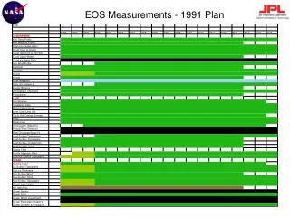
24 EOS Measurements ATMOSPHERE sensor • Cloud Properties: MODIS, GLAS, AMSR-E, MISR, AIRS, (amount, optical properties, height) ASTER, SAGE III • Radiative Energy Fluxes: CERES, ACRIM III, MODIS, AMSR-E, GLAS, (top of atmosphere, surface): MISR, AIRS, ASTER, SAGE III • Precipitation: AMSR-E • Tropospheric Chemistry: TES, MOPITT, SAGE III, MLS, HIRDLS, LIS (ozone, precursor gases) • Stratospheric Chemistry: MLS, HIRDLS, SAGE III, OMI, TES (ozone, ClO, BrO, OH, trace gases) • Aerosol Properties: SAGE III, HIRDLS, MODIS, MISR, (stratospheric, tropospheric): OMI, GLAS • Atmospheric Temperature: AIRS/AMSU-A, MLS, HIRDLS, TES, MODIS • Atmospheric Humidity: AIRS/AMSU-A/HSB, MLS, SAGE III, HIRDLS, Poseidon 2/JMR/DORIS, MODIS, TES • Lightning: LIS
24 EOS Measurements 2 OCEANsensor • Surface Temperature: MODIS, AIRS, AMSR-E • Phytoplankton & Dissolved Organic Matter: MODIS • Surface Wind Fields: SeaWinds, AMSR-E, Poseidon 2/JMR/DORIS • Ocean Surface Topography: Poseidon 2/JMR/DORIS (height, waves, sea level) LAND • Land Cover & Land Use Change: ETM+, MODIS, ASTER, MISR • Vegetation Dynamics: MODIS, MISR, ETM+, ASTER • Surface Temperature: ASTER, MODIS, AIRS, AMSR-E, ETM+ • Fire Occurrence: MODIS, ASTER, ETM+ (extent, thermal anomalies) • Volcanic Effects: MODIS, ASTER, ETM+, MISR (frequency of occurrence, thermal anomalies, impact) • Surface Wetness: AMSR-E CRYOSPHERE • Land Ice: GLAS, ASTER, ETM+ (ice sheet topography, ice sheet volume change, glacier change) • Sea Ice: AMSR-E, Poseidon 2/JMR/DORIS, MODIS, ETM+, ASTER (extent, concentration, motion, temperature) • Snow Cover: MODIS, AMSR-E, ASTER, ETM+ (extent, water equivalent)
Global Sea Surface Temperature June 1, ‘03 33kb AMSR-E on AQUA
Aerosol optical depth 125kb
Typhoon Etau over Japan, Aug 4, ‘03 Trimm 39kb TRMM
Hawaii Islands wake 24kb SeaWiFS
Phytoplankton bloom So.Atlantic SeaWifs
SST - La Nina? 44kb MODIS • These Jason data were taken during a • 10-day collection cycle ending July 3, 2003.
Atmospheric Vertical Moisture Profile Downward Longwave Radiance (Sfc) Precipitable Water Electric Fields Precipitation Type/Rate Atmospheric VerticalTemperature Profile Imagery EDPs/Ionospheric Specification Pressure (Surface/Profile) Sea Surface Temperature Fresh Water Ice Radiation Belt/Low Energy Particles Sea Surface Winds Geomagnetic Field Sea Ice Age and EdgeMotion Soil Moisture Ice Surface Temperature Sea Surface Height/Topography Aerosol Optical Thickness In-situ Ion Drift Velocity Snow Cover/Depth Aerosol Particle Size In-situ Plasma Density Solar EUV Flux Albedo (Surface) In-situ Plasma Fluctuations Solar Irradiance Auroral Boundary In-situ Plasma Temperature Solar/Galactic Cosmic Ray Particles Auroral Imagery Insolation Supra-Thermal - Auroral Particles Cloud Base Height Ionospheric Scintillation Surface Wind Stress Cloud Cover/Layers Land Surface Temperature Suspended Matter Cloud Effective Particle Size Littoral Sediment Transport Total Auroral Energy Deposition Cloud Ice Water Path Net Heat Flux Total Longwave Radiance (TOA) Cloud Liquid Water Net Short Wave Radiance (TOA) Total Water Content Cloud Optical Depth/Transmittance NDPs/Neutral Atm Specification Turbidity Cloud Top Height Normalized Difference Vegetation Index Upper Atmospheric Airglow Cloud Top Pressure Ocean Color/Chlorophyll Vegetation Index/SurfaceType Cloud Top Temperature Ocean Wave Characteristics Currents (Ocean) Ozone - Total Column/Profile Environmental Data Records (EDRs) with Key Performance Parameters VIIRS CMIS OMPS SESS GPSOS ERBS TSIS ALT CrIS/ATMS Primary Contributions to EDRs by Sensor
Ocean ObserverA Potential Partnership for An Active Remote Sensing SatellitePresentation to theFirst Ocean Observer Joint Working GroupAugust 4, 2000Silver Spring, MarylandJohn Cunningham, NOAAProgram Director, NPOESS Integrated Program Office
A Tri-agency Effort to Leverage and Combine Environmental Satellite Activities METOP NPOESS Mission Provide a national, operational, polar-orbiting remote-sensing capability Achieve National Performance Review (NPR) savings by converging DoD and NOAA satellite programs Incorporatenew technologies from NASA Encourage International Cooperation 0530 1330 0930 NPOESS Saves > $1.8B through System Life Cycle compared to NPR target of $1.3B NPOESS is Good Government!
Atmospheric Vertical Moisture Profile Downward Longwave Radiance (Sfc) Precipitable Water Electric Fields Precipitation Type/Rate Atmospheric VerticalTemperature Profile Imagery EDPs/Ionospheric Specification Pressure (Surface/Profile) Sea Surface Temperature Fresh Water Ice Radiation Belt/Low Energy Particles Sea Surface Winds Geomagnetic Field Sea Ice Age and EdgeMotion Soil Moisture Ice Surface Temperature Sea Surface Height/Topography Aerosol Optical Thickness In-situ Ion Drift Velocity Snow Cover/Depth Aerosol Particle Size In-situ Plasma Density Solar EUV Flux Albedo (Surface) In-situ Plasma Fluctuations Solar Irradiance Auroral Boundary In-situ Plasma Temperature Solar/Galactic Cosmic Ray Particles Auroral Imagery Insolation Supra-Thermal - Auroral Particles Cloud Base Height Ionospheric Scintillation Surface Wind Stress Cloud Cover/Layers Land Surface Temperature Suspended Matter Cloud Effective Particle Size Littoral Sediment Transport Total Auroral Energy Deposition Cloud Ice Water Path Net Heat Flux Total Longwave Radiance (TOA) Cloud Liquid Water Net Short Wave Radiance (TOA) Total Water Content Cloud Optical Depth/Transmittance NDPs/Neutral Atm Specification Turbidity Cloud Top Height Normalized Difference Vegetation Index Upper Atmospheric Airglow Cloud Top Pressure Ocean Color/Chlorophyll Vegetation Index/SurfaceType Cloud Top Temperature Ocean Wave Characteristics Currents (Ocean) Ozone - Total Column/Profile Environmental Data Records (EDRs) with Key Performance Parameters VIIRS CMIS OMPS SESS GPSOS ERBS TSIS ALT CrIS/ATMS Primary Contributions to EDRs by Sensor
Environmental Data Records (EDRs) with Key Performance Parameters Environmental Data Records Atmospheric Vertical Moisture Profile Precipitable Water Downward Longwave Radiance (Sfc) Electric Fields Precipitation Type/Rate Atmospheric Vertical Temperature Profile Imagery EDPs/Ionospheric Specification Pressure (Surface/Profile) Sea SurfaceTemperature Fresh Water Ice Radiation Belt/Low Energy Particles Sea SurfaceWinds Geomagnetic Field Sea Ice Age and EdgeMotion Soil Moisture Ice Surface Temperature Sea SurfaceHeight/Topography Aerosol Optical Thickness In-situ Ion Drift Velocity Snow Cover/Depth Aerosol Particle Size In-situ Plasma Density Solar EUV Flux Albedo (Surface) In-situ Plasma Fluctuations Solar Irradiance Auroral Boundary In-situ Plasma Temperature Solar/Galactic Cosmic Ray Particles Auroral Imagery Insolation Supra-Thermal - Auroral Particles Cloud Base Height Ionospheric Scintillation Surface Wind Stress Cloud Cover/Layers Land Surface Temperature Suspended Matter Cloud Effective Particle Size Littoral Sediment Transport Total Auroral Energy Deposition Cloud Ice Water Path Net Heat Flux Total Longwave Radiance (TOA) Cloud Liquid Water Net Short Wave Radiance(TOA) Total Water Content Cloud Optical Depth/Transmittance NDPs/Neutral Atm Specification Turbidity Cloud Top Height Upper Atmospheric Airglow Normalized Difference Vegetation Index Cloud Top Pressure Ocean Color/Chlorophyll Vegetation Index/Surface Type Cloud Top Temperature Ocean Wave Characteristics Currents (Ocean) Ozone - Total Column/Profile Atmospheric Oceanic Terrestrial Space Climate TSIS ALT
Notional Payloads to Satisfy NPOESS Requirements METOP NPP NPOESS Payloads 1330 0930 0530 1030 IPO Developed Visible/IR Imager Radiometer Suite (VIIRS)* X X X (AVHRR) X Cross-track IR Sounder (CrIS)* X X (IASI/HIRS) X Conical MW Imager/Sounder (CMIS)* X X Ozone Mapping and Profiler Suite (OMPS) X X (GOME) GPS Occultation Sensor (GPSOS) X X X (GRAS) Space Environmental Sensor Suite (SESS) X X X (SEM) Leveraged Advanced Technology MW Sounder (ATMS)* X X (AMSU/MHS) X Data Collection System (DCS) X X X Search and Rescue (SARSAT) X X Earth Radiation Budget Sensor X Solar Irradiance Sensor (TSIS) X Radar altimeter (ALT) X Advanced Scatterometer (ASCAT) X * Critical payload - Failure constitutes need to replace satellite
VIIRS Visible/Infrared Imager Radiometer Suite ITT Aerospace Raytheon, SBRS CrIS Cross Track Infrared Sounder ITT Aerospace Provides cross-track measurements of scene radiance to permit the calculation of the vertical distribution of temperature, moisture, and pressure in the Earth’s atmosphere. Primary contributions for satisfying 3 EDRs. Collects visible/infrared imagery and radiometric data to produce a variety of imagery, meteorological, and oceanographical products. Product types include clouds, atmospheric, Earth radiation budget, clear-air land/water surfaces (including ocean color products), and low light visible imagery. Primary contributions for satisfying 26 EDRs. OMPS Ozone Mapping and Profiler Suite Ball Aerospace GPSOS GPS Occultation Sensor Saab Ericsson Measures the refraction of radiowave signals vis occultations with GPS and Russia’s GLONASS satellites to determine state of Ionosphere. Primary contributions for satisfying 2 EDRs. Collect specialized data to permit the calculation of the vertical and horizontal distribution of Ozone in the earth’s atmosphere. Primary contributions for satisfying 1 EDR. IPO Sensor/Algorithm Risk Reduction Contracts CMIS Conical Microwave Imager Sounder Ball Aerospace Hughes Space & Communications Collects microwave radiometry and sounding data to develop a variety of meteorological and oceanographical products. Product types include clouds, atmospheric profiles, and all-weather land/water surfaces. Primary contributions for satisfying 20 EDRs.
IPO Sensor/Algorithm Risk Reduction Contract Status SRR System Requirements Review SFR System Functional Review PDR Preliminary Design Review CFI Call For Improvement CDR Critical Design Review First Unit Delivery CrIS Cross-track IR Sounder 3/98 12/98 4/99 5/99 7/01 4/04 OMPS Ozone Mapping & Profiler Suite 11/97 8/98 1/99 2/99 4/03 7/05 GPSOS GPS Occultation Sensor 11/97 6/98 11/98 3/03 1/03 7/05 7/04 VIIRS Visible/IR Imager Radiometer Suite 1/99 10/99 5/00 6/00 8/01 CMIS Conical Microwave Imager Sounder 11/98 8/99 2/01 3/01 9/02 9/05
Joint IPO/DoD/NASA Risk Reduction Demo WindSat/Coriolis Description:Measures Ocean Surface Wind Speed, Wind Direction, Using Polarimetric Radiometer on a Modified Satellite Bus, Launched Into a 830 km 98.7° Orbit by the Titan II Launch Vehicle. 3 Year Design Lifetime. • Capability/Improvements • Measure Ocean Surface Wind Direction (Non- Precipitating Conditions) • 25km spatial resolution • Secondary Measurements • Sea Surface Temperature, Soil Moisture, Rain Rate, Ice, and Snow Characteristics, Water Vapor
NPP Preliminary Mission Concept • Payloads: Cross-track IR Sounder (CrIS), Advanced Technology Microwave Sounder (ATMS), Visible IR Imager Radiometer Suite (VIIRS) • Orbit: 833 km, Polar Sun-Synchronous, 1030 a.m. Descending Node • Launch Readiness Date: 2005 • Mission Life: 5 years • Stored Mission Data Transmission to Polar Ground Stations (Ka- or X-band) • Direct Broadcast of Real-time Data (X-band) • Primary Command and Control: S-band Space-Ground • Back-up: S-band through TDRSS and AF Satellite Control Network
U.S. civil and defense programs, working in partnership with EUMETSAT, will ensure improved global coverage and long-term continuity of observations at less cost! Evolution METOP POES METOP Yesterday • 4-Orbit System • 2 US Military • 2 US Civilian NPOESS DMSP DMSP 0830 0730 1330 0530 1330 1330 0930 0530 0930 0830 0530 POES POES Future (2012) • 3-Orbit System • 2 US Converged • 1 EUMETSAT/METOP • 1 US “light” Local Equatorial Crossing Time Local Equatorial Crossing Time Today (2003) • 4-Orbit System • 2 US Military • 1 US Civilian • 1 EUMETSAT/METOP DMSP Local Equatorial Crossing Time DMSP NPOESS
Polar-orbiting Satellites • Complement Geostationary Satellites • Provide Global Coverage, Particularly at High Latitudes • Acquire Higher Spatial Resolution Data Operational System • Real-time environmental data 24 hours a day, 7 days a week • Supports both civilian and military missions • Continuity with existing systems/planned systems • Commitment to support long-term data continuity for environmental monitoring and Global Change assessment Environmental System • A Total Environmental Monitoring System • Transitions between operational, short-term weather forecasting and long-term global change missions
What is Ocean Observer? • Operational data for Navy and NOAA • Science data for NASA and NOAA • R&D sensor proof of concept for NASA • Operational transition for NASA and NOAA • Team approach to solving mutual problems at reduced agency cost for OMB • Oceans mainly