Download
1 / 14
140 likes | 248 Views
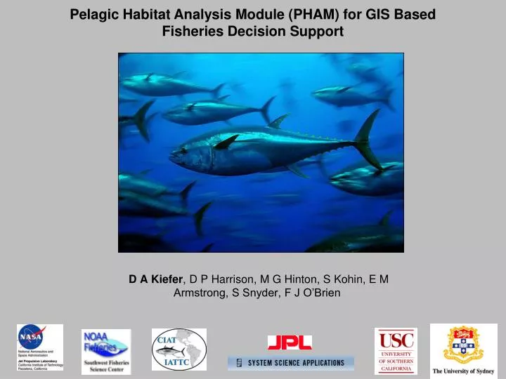
Pelagic Habitat Analysis Module (PHAM) for GIS Based Fisheries Decision Support. D A Kiefer , D P Harrison, M G Hinton, S Kohin , E M Armstrong, S Snyder, F J O’Brien. Pelagic Habitat Analysis Module (PHAM). Fisheries Catch/Survey Data. Tagging Data. Satellite Imagery.

E N D
Pelagic Habitat Analysis Module (PHAM) for GIS Based Fisheries Decision Support D A Kiefer, D P Harrison, M G Hinton, S Kohin, E M Armstrong, S Snyder, F J O’Brien
Pelagic Habitat Analysis Module (PHAM) Fisheries Catch/Survey Data Tagging Data Satellite Imagery Circulation Model EASy GIS PHAM Tools & Statistics visit runeasy.com Dynamic Maps of Habitat Data & Results of Statistical Analysis
Improving Fisheries Management Stock Assessment / By-catch Tuna of the EPO • Important Commercial Species ($2-3 B annual revenues Eastern Pacific) • Stock assessment models only provide a reliable estimate of recruitment several years after the fact • Very little (if any) environmental data used in stock assessment models Sharks of the California Current • Stock assessment model for Thresher Sharks – Input from PHAM GAM • By-catch Management – Where does habitat overlap commercial fishing? • Distribution of pregnant females
Mako Shark (Isurus oxyrhynchus) Blue Shark (Prionace glauca), Common Thresher Shark (Alopias vulpinus)
Fisheries Data Environmental Characteristics • Survey Data • Commercial Catch Data • Vessel Logbook Data • Recreational Fishing Data • Tagging data (not yet) • Satellite Imagery • Seawifs Chl • Modis Chl • Modis SST • GHRSST • AVHRR SST • AVISO SSH • Quickscatt Winds • NOAA Coastwatch Frontal Probability • NSA JPL Frontal Probability • EPTO Bathymetry • NASA ECCO 2 Model • Mixed Layer Depth • SST • Temperature at Depth • SSH • Sea Surface Salinity • Currents • EASy Built In • Earth Magnetic Field • Longitude • Latitude • Month
Average catch per set (Purse Seine) Tuna, IATTC 35yrs Average catch per set (Purse Seine) for Yellowfin Tuna, IATTC 35 Yr Timeseries Average Catch Number by Sex – Common Thresher Shark, SWFSC Average Catch Market Squid
Environmental Characteristics GHRSST Sea Surface Temperature SeaWiFS Chlorophyll NOAA Coastwatch Frontal Probability NASA ECCO2 Ocean Currents
PHAM screen of habitat analysis interface, map of calculated spawning sites, and graphical results of analysis
JAN FEB MAR APR MAY JUN JUL AUG SEP OCT NOV DEC PHAM Common Thresher Shark Habitat Prediction for 2000 based on chlorophyll and SST
Warm Years: 1998-2009 The habitat scale is derived from a non‑linear and multidimensional combination of concurrent sea‑surface temperature, chlorophyll concentration and the gradient derived from sea‑surface height images. The pattern described by the seasonal movement of the habitat explains the fisheries patterns of US and Canada and the migrations routes suggested in the 1940's. Unpublished results kindly provided by Juan P. Zwolinski, Robert L. Emmett, and David A. Demer of the Southwest Fisheries Science Center.
Conclusions • We have assembled a system that integrates satellite and model output with fisheries data • We have developed tools that allow analysis of the interaction between species and key environmental variables • Demonstrated the capacity to accurately map habitat of Thresher Sharks Alopiasvulpinus & pelagicus. Their seasonal migration along the California Current is at least partly driven by the seasonal migration of sardine, key prey of the sharks. • If you are interested in using PHAM software (free) please contact kiefer@usc.edu. Initial Tasks for this Year • Incorporate electronic tag tracks for Bigeye and Yellowfin tuna of the Eastern Pacific in order to define the 3 dimension of their habitat. • Apply PHAM tools to building a stock assessment model for thresher sharks that will be used by SWFSC to regulate coastal recreational and commercial fisheries. • Build interface between our EASy geographical Information System and R statistics program.