Download
1 / 55
550 likes | 555 Views
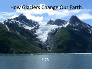
Sculpting the Earth’s Surface. Glaciers, Deserts, and Wind. Glaciers. Glaciers are a part of both the hydrologic cycle and rock cycle A thick mass of ice that originates on land from the accumulation, compaction, and recrystallization of snow. Glaciers. Location

E N D
Sculpting the Earth’s Surface Glaciers, Deserts, and Wind
Glaciers • Glaciers are a part of both the hydrologic cycle and rock cycle • A thick mass of ice that originates on land from the accumulation, compaction, and recrystallization of snow
Glaciers • Location • Occupy 10% of Earth’s surface • Primarily located in polar regions (Antarctica & Greenland) • But found on every continent • Form above the snow line
Glaciers • Formation • New layers form each year • Weigh of overlying layers compresses buried layers • Snow recrystallizes – looks like sugar • Snow begins to grow, air pockets decrease • compacts & becomes very dense • After 2 winters => FIRN
Glaciers • Formation (continued) • Firn • Generally 16x the size of a snow crystal • ½ as dense as water • Increase in size as the overburden increases • Over time, grows to form even larger crystals • Forms glacial ice
Glaciers • Movement • When ice sheet thickness > 18 meters, the ice sheet: • Deforms • Flows • Movement slower at base than at top • Advance and retreat • Surge
Glaciers • Types of glacial movements • Plastic flow • Basal slip
Glaciers • Rates of movement • Average velocities vary considerably • Rates of up to several meters per day • Some glaciers exhibit extremely rapid movements called surges
Glaciers • Movement (continued) • Budget of a glacier • Accumulation + loss = glacial budget
If accumulation exceeds loss (called ablation), the glacial front advances
If ablation increases and/or accumulation decreases, the ice front will retreat
Crevasses Moraines Glaciers • Features Barnard Glacier http://nsidc.org/glaciers/questions/components.html
Ice Ice Sheets, Ice Shelves, Ice Caps, Ice Streams, and Ice fields Glaciers Mountain Glaciers, Valley Glaciers, Piedmont Glaciers, Cirque Glaciers, Hanging Glaciers, Tidewater Glaciers. Glaciers • Types
Glaciers • Glaciers erode by • Plucking – lifting of rock blocks • Abrasion • Rock flour (pulverized rock) • Striations (grooves in the bedrock)
Glaciers • Glacial deposits • Glacial drift • All sediments of glacial origin • Types of glacial drift • Till – material that is deposited directly by ice • Stratified drift - sediment deposited by meltwater
Glaciers • Glacial deposits • Depositional features • Moraines – layers or ridges of till • Types of moraines • Lateral • Medial • End • Ground
Glaciers • Glacial deposits • Depositional features • Outwash plain, or valley train • Kettles • Drumlins • Eskers • Kames
Glaciers • Ice Ages • Have occurred throughout Earth’s history
Glaciers • Ice Age • Began 2 to 3 million years ago • Division of geological time is called the Pleistocene epoch • Ice covered 30% of Earth's land area
Glaciers • Indirect effects of Ice Age glaciers • Migration of animals and plants • Rebounding upward of the crust • Worldwide change in sea level • Climatic changes
Glaciers • Causes of glaciation • Successful theory must account for • Cooling of Earth, as well as • Short-term climatic changes
Glaciers • Causes of glaciation • Proposed possible causes • Plate tectonics • Continents were arranged differently • Changes in oceanic circulation (Thermohaline Current)
Glaciers • Causes of glaciation • Proposed possible causes • Variations in Earth's orbit • The Milankovitch hypothesis • Shape (eccentricity) of Earth’s orbit varies • Angle of Earth’s axis (obliquity) changes • Earth’s axis wobbles (precession)
Desert • Definition : • A region so arid that it contains no permanent streams except for those that bring water in from elsewhere, and has very sparse vegetation cover. • NOT related to temperature! • Deserts can be • Hot (>35 °C) • Cold (< 20 °C)
Desert • Location • Dry regions cover 30% of Earth’s land surface
Desert • Types of deserts • Two climatic types are commonly recognized • Desert or arid • Steppe or semiarid
Deserts • Types of deserts • Classified by environment in which they are formed • subtropical: in the hot dry latitudes between 20 and 30°, both north and south • rain shadow: on the landward side of coastal mountain ranges • coastal: along coasts bordering cold ocean currents • continental interior: deep within continents, far from major water sources • polar: in the cold dry polar regions, both north and south
Earth’s dry regions coincide with the subtropical high pressure belts & solar heating
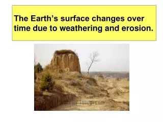
Deserts • Weathering and Erosion • Not as effective as in humid regions • Mechanical weathering forms unaltered rock and mineral fragments • Some chemical weathering does occur • Clay forms • Thin soil forms
Deserts • Weathering and Erosion • Water Erosion • Desert rainfall • Rain often occurs as heavy showers • Causes flash floods • Poorly integrated drainage • Most erosional work in a desert is done by running water
Deserts • Weathering and Erosion • Water Erosion • Streams are dry most of the time • Desert streams are said to be ephemeral • Flow only during periods of rainfall • Different names are used for desert streams including wash, arroyo, wadi, donga, and nullah
Deserts • Weathering & Erosion • Wind erosion • Differs from that of running water in two ways • Wind is less capable of picking up and transporting coarse materials • Wind is not confined to channels and can spread sediment over large areas
Deserts • Weathering & Erosion • Wind erosion • Mechanisms of transport • Bedload • Saltation – skipping and bouncing along the surface • Suspended load • In the air as duststorms
Deserts • Weathering & Erosion • Wind erosion • Mechanisms of wind erosion • Deflation • Lifting of loose material • Produces Blowouts & Desert pavement
Deserts • Weathering & Erosion • Wind erosion • Mechanisms of wind erosion • Abrasion • Produces ventifacts (stones with flat faces) and yardangs (wind sculpted ridges) • Limited in vertical extent
Deserts • Depositional Environments • Water Deposits • Talus Aprons • Alluvial Fans • Bajada • Playas and Salt Lakes
Deserts • Depositional Environments • Wind deposits • Dunes • Mounds or ridges of sand • Often asymmetrically shaped • Characteristic features • Slip face • Cross beds
Deserts • Depositional Environments • Wind deposits • Loess • Deposits of windblown silt • Extensive blanket deposits • Primary sources are deserts and glacial stratified drift
Deserts • Basin and Range: the evolution of a desert landscape • Uplifted crustal blocks • Interior drainage into basins produces • Alluvial fans and bajadas • Playas and playa lakes
Deserts • Basin and Range: the evolution of a desert landscape • Erosion of mountain mass causes local relief to continually diminish • Eventually mountains are reduced to a few large bedrock knobs called inselbergs projecting above a sediment filled basin