Download
1 / 63
640 likes | 825 Views
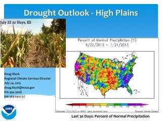
Dual-polarimetric and multi-Doppler analysis of a High Plains supercell. Darren Clabo Nick Guy Nathan Hitchens. Outline. Introduction Background Dual-polarimetric Doppler analysis Multi-Doppler analysis Summary. Introduction. Soundings. RIW. LBF. DNR. Surface Observations.

E N D
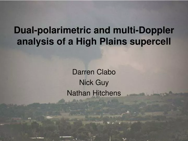
Dual-polarimetric and multi-Doppler analysis of a High Plains supercell Darren Clabo Nick Guy Nathan Hitchens
Outline • Introduction • Background • Dual-polarimetric Doppler analysis • Multi-Doppler analysis • Summary
Soundings RIW LBF DNR
Storm Information • Initiation: 2337 UTC on 4 June 2009 • First reflectivity seen aloft (8.81 km) at 2326 UTC on 4 June 2009 • Last radar scan by CSU-CHILL at 0112 UTC on 5 June 2009
1km Visible Satellite Storm initiation
Supercell Model Klemp (1987)
Polarimetric Radar Signatures in Supercell Thunderstorms Kumjian and Ryzhkov (2008)
Polarimetric Radar Signatures in Supercell Thunderstorms • ZDR arc signature • Usually found on the right southern edge of the forward flank downdraft • Shallow (1-2 km in depth) • Effect of size sorting of raindrops resulting from vertical increase in speed and veering of storm-relative winds Kumjian and Ryzhkov (2008)
Polarimetric Radar Signatures in Supercell Thunderstorms • Hail signature • Low ZDR value (near 0) due to chaotic orientation of tumbling hailstones Kumjian and Ryzhkov (2008)
Polarimetric Radar Signatures in Supercell Thunderstorms • Inflow signature • Vigorous low-level inflow into supercells may contain nonmeteorological scatterers (e.g. grass, leaves, dust) • Results in lower values of ρHV Kumjian and Ryzhkov (2008)
Polarimetric Radar Signatures in Supercell Thunderstorms • Updraft signature • Light debris may be ingested into updraft from inflow and a lack of hydrometeors may exist • Results in low ρHV aloft
Polarimetric Radar Signatures in Supercell Thunderstorms • ZDR columns • High values associated with updrafts indicative of large raindrops or water-coated hailstones • Narrow (4-8 km wide) • Increasing values associated with updraft intensification, and thus storm intensification Kumjian and Ryzhkov (2008)
Radar Coverage • Dual-polarized, S-band • CSU-CHILL • Single-polarized, S-band • CSU-PAWNEE • Denver NEXRAD (KFTG) • Cheyenne NEXRAD (KCYS)
Storm undergoing new updraft growth • Vorticity calculated using the tangential shear between two points corresponding to the maximum inbound and outbound velocities not more than 10 km apart in an area thought to contain the updraft • Updraft denoted by bounded weak echo region aloft • Red line denotes minimum vertical vorticity for a mesocyclone as described by the synthesis of Bunkers et al. (2009)
0109 UTC – Base Updraft Updraft Updraft Updraft
0109 UTC – Sweep 4 Updraft Updraft Updraft Updraft
Multi-Doppler Analyses • Radar data edited in SOLOII • Removal of egregious data • Interpolated to Cartesian grid via REORDER software package • Dual- and Multi-Doppler analyses performed with CEDRIC software package • Extremely finicky!
Multi-Doppler Analyses Quad Triple Dual Dual
Vertical Wind Calculation Upward integration Downward integration Variable Integration
Continuity 090605_0109Z 090605_0106Z
Vertical Structure 1.50 km 3.0 km
Vertical Structure 4.50 km 6.5 km
Vertical Structure 8.0 km 10.0 km