Download
1 / 5
200 likes | 780 Views
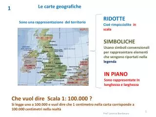
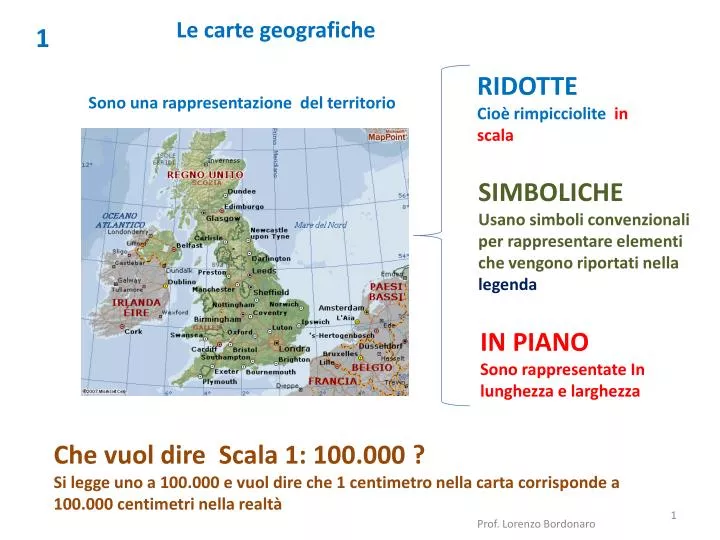
1. RIDOTTE Cioè rimpicciolite in scala. S ono una rappresentazione del territorio. L e carte geografiche . SIMBOLICHE Usano simboli convenzionali per rappresentare elementi che vengono riportati nella legenda. IN PIANO Sono rappresentate In lunghezza e larghezza .

E N D
1 RIDOTTE Cioè rimpicciolitein scala Sono una rappresentazione del territorio Le carte geografiche SIMBOLICHE Usano simboli convenzionali per rappresentare elementi che vengono riportati nella legenda IN PIANO Sono rappresentate In lunghezza e larghezza Che vuol dire Scala 1: 100.000 ? Si legge uno a 100.000 e vuol dire che 1 centimetro nella carta corrisponde a 100.000 centimetri nella realtà Prof. Lorenzo Bordonaro
2 In base alla scala si possono avere vari tipi di carte PIANTE O MAPPE SCALA da 1: 10.000 (centri urbani o zone rurali) Classificazione delle carte geografiche carte a grande scala CARTE TOPOGRAFICHE SCALA da 1: 10.000 fino a 1:100.000 (zone abbastanza ampie di territorio) Prof. Lorenzo Bordonaro
3 CARTE COROGRAFICHE SCALA da 1: 100.000 fino a 1:1.000.000 (intere regioni o stati) carte a piccola scala CARTE GEOGRAFICHE SCALA da 1: 1.000.000 a 1: 30.000.000 (più stati o un intero continente) PLANISFERI SCALA da 1: 30.000.000 fino a 1:100.000.000 (l’intera superficie terrestre) Prof. Lorenzo Bordonaro
4 Servono a far capire se un territorio è posto più in alto o più in basso rispetto ad un altro o se in un certo punto il mare è più o meno profondo. ALTIMETRIA Indica l’altezza Curve di livello BATIMETRIA Indica la profondità Prof. Lorenzo Bordonaro
5 In base ai contenuti le carte geografiche possono essere: FISICHE RIPORTANO TUTTE LE CARATTERISTICHE FISICHE DI UN TERRITORIO (MONTI, PIANURE, FIUMI…) Classificazione delle carte geografiche in base ai contenuti POLITICHE RIPORTANO LE DIVISIONI POLITICO-AMMINISTRATIVE E GLI INSEDIAMENTI (CITTA’ E CENTRI ABITATI) TEMATICHE ILLUSTRANO UN ASPETTO O UN FENOMENO RELATIVO AL TERRITORIO RAPPRESENTATO (ES. CARTE CLIMATICHE, GEOLOGICHE, SOCIO-ECONOMICHE) Prof. Lorenzo Bordonaro