Download
1 / 47
470 likes | 474 Views
The National Map Viewer is a relational database that provides access to web mapping services for querying and viewing geospatial data. Easily search and retrieve data using URL syntax.

E N D
The National Map Viewer is part of The National Map System
However: The National Map is NOT the Viewer
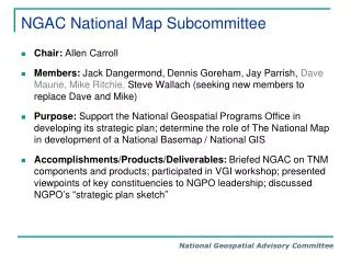
The National Map is a Relational Database
ele_srs spat_ref_sys This Relational Database is called The National Map Catalog 0..* 0..* 1 SRSID ID ELEMENTID EPSGCODE NAME DESCRIPTION ele_class elements 1 partn services 1 0..* ELEMENTID ID 1 1 1 1 CLASSID SERVICEID ID ID 0..* 0..* TITLE NAME NAME NAME WEBURL TYPE MBRID LOURL URL FOOTPRINTID GETCAPURL ACCURACY PARTNERID 0..* TIMEPERIOD class VERSION PREDILECT STATUS 1 STATUS ID GETMAPURL themes TYPE NAME GETFEATURL 1..* 1 QUERYABLE THEMEID AVAILABLE ID LAYERTYPE DEPTHFAC BACKINGURL NAME RANSLUCENCY BACKSERVICE DEPTHFAC DENSITY BACKVERSION RESOLUTION MINVWSCALE MAXVWSCALE MINPRSCALE Ele_sets MAXPRSCALE ele_set_memb METADATAURL 1 0..* ID LOGOURL ELEMENTSETID 0..* NAME SLDURL ELEMENTID DESCR LEGENDURL GROUPID DESCRIPTION TNM Catalog 0..* PARTNERID SCALCLASSID BACKINGNAME DWNLOADABLE GROUPID FILTER SYMBGROUPID ELEMENTID
Internet Generic View of a Web Mapping Service Client
Internet Generic View of a Web Mapping Service Query a Service using URL Syntax Client Service WMS
Internet Source of Data Generic View of a Web Mapping Service Service Queries for GIS Data Client Service WMS
Internet Source of Data Generic View of a Web Mapping Service Client Service WMS Response is Typically HTML or XML, but can be Text, Raster Images or other Formats
Source of Data WMS Simple to Complex WMS Relationships Client
Source of Data Source of Data WMS WMS Simple to Complex WMS Relationships Client Client
Source of Data Source of Data Source of Data WMS WMS WMS Simple to Complex WMS Relationships Client Client Client
Source of Data Source of Data Source of Data WMS WMS WMS Simple to Complex WMS Relationships Client Client Client
Source of Data Source of Data Source of Data Source of Data WMS WMS WMS WMS Simple to Complex WMS Relationships Client Client Client
Source of Data Source of Data Source of Data Source of Data WMS WMS WMS WMS Simple to Complex WMS Relationships Client Application Data Management Becomes Increasing Complex As Clients and Data Sources are Added Client Client
Source of Data Source of Data Source of Data Source of Data WMS WMS WMS WMS Simplified WMS Relationships Client Application Data Management Becomes Increasing Complex As Clients and Data Sources are Added Relational Database Client Client
Source of Data Source of Data Source of Data Source of Data WMS WMS WMS WMS Add a web service to the Database Client Relational Database Web service Client Client
Source of Data Source of Data Source of Data Source of Data WMS WMS WMS WMS The National MapCatalog Client TNM Catalog Client Client
TNM Catalog Source of Data Source of Data Source of Data Source of Data WMS WMS WMS WMS The National MapCatalog This Architecture is also Client SCALABLE! Client Client
Viewer Application Client Client Application The National MapSystem WMS Partner Data WMS TNM Catalog Partner Data WMS Other Fed TNM Data WMS USGS TNM Data
Viewer App Indiana State Data Viewer Application Client Client Application Indiana County Data The National MapSystem WMS WMS TNM Catalog WMS Other Fed TNM Data The State of Indiana Joins The National Map WMS USGS TNM Data
Viewer App Indiana State Data Indiana County Data The National MapSystem WMS WMS TNM Catalog Viewer Application Client Client Application WMS Using TNM Catalog Application Programmer’s Interface (API), National And Local Base Layer GIS Data Can Be Made Available to Multiple Independent Applications Other Fed TNM Data WMS USGS TNM Data
Viewer App Indiana State Data Indiana County Data WMS Other GIS Data The National MapSystem WMS WMS TNM Catalog Viewer Application Client Application Client WMS Other Fed TNM Data API Independent Applications WMS USGS TNM Data
WMS Viewer App Indiana State Data WMS GOS Directory TNM Catalog Viewer Application Client Application Client Indiana County Data WMS Other Fed TNM Data API Independent Applications WMS WMS Other GIS Data USGS TNM Data Register Once – TNM and GOS The National Map Catalog is also a Source of Content for Geospatial One-Stop Geospatial One-Stop is Updated Weekly from TNM Catalog
State of Indiana Jill Saligoe-Simmel, Ph.D. Indiana Geographic Information Council, Inc. 317-234-2924 jsaligoe@iupu.edu www.in.gov/ingisi Who’s Who in The National MapPartner Registration Process US Geological Survey Charley Hickman, USGS Liaison to IN, MI, OH USGS Eastern Region Geog 614-430-7768 chickman@usgs.gov www.usgs.gov/ngpo
State of Indiana Jill Saligoe-Simmel, Ph.D. Partner Registration Process US Geological Survey Charley Hickman, USGS Potential Partners? Indiana State Agency Local Government Academic Institution Regional Consortium Private Concern ER Catalog Support Team Reston, VA - Art Eckerson CR Catalog Support Team Rolla, MO – Larry Moore POCs
Catalog Support Team Member Contacts Partner POC and Initiates Information Gathering: Data Types FGDC Metadata? WMS? OGC Compliant? URLs for: All WMSs Metadata Legends Public/Non-Public Layers Min/Max Scale for each Layer Data Layer Footprints Partner Information Page URL This is an Iterative Process
Catalog Support Team Verifies all URLs Determines Classification of Data Layers to: TNM Themes ‘Other’ Categories Reviews Layer Scale and Symbology Reviews Place Names and Initiates GNIS Internal USGS Names Extraction Processes Reviews Metadata These Actions also Require Iteration with the Partner
Catalog Support Team Initiates TNM Catalog Data Entry Process:
Catalog Support Team Initiates TNM Catalog Data Entry Process: Establishes a Partner ID Number with CST in Rolla, MO Registers each WMS and Classify each Layer of the Service Tests in TNM (LIVE) Again, the Catalog Support Team Iterates with the Partner to Properly Register Partner Data in TNM Catalog
Partner Assistance: Lacking FGDC Compliant Metadata? Catalog Support Teams (and Others) can Offer Assistance in Metadata Training, Some Metadata Content Entry (Caveat!! Contingent on Availability of Resources) No WMS? If Partner Plans to Move Toward a Local WMS Capability, Temporary Hosting and Serving of Data may be Possible via Indiana Map and/or USGS (More Caveats!!)
Review > The National Map Catalog A Scalable, Relational Database that SimplifiesWMS Data Management Functions, and is Capable ofProviding Base Layer GIS Data to Multiple Applications
State of Indiana Jill Saligoe-Simmel, Ph.D. Indiana Geographic Information Council, Inc. 317-234-2924 jsaligoe@iupu.edu www.in.gov/ingisi Contact Information US Geological Survey Charley Hickman, USGS Liaison to IN, MI, OH USGS Eastern Region Geog 614-430-7768 chickman@usgs.gov www.usgs.gov/ngpo
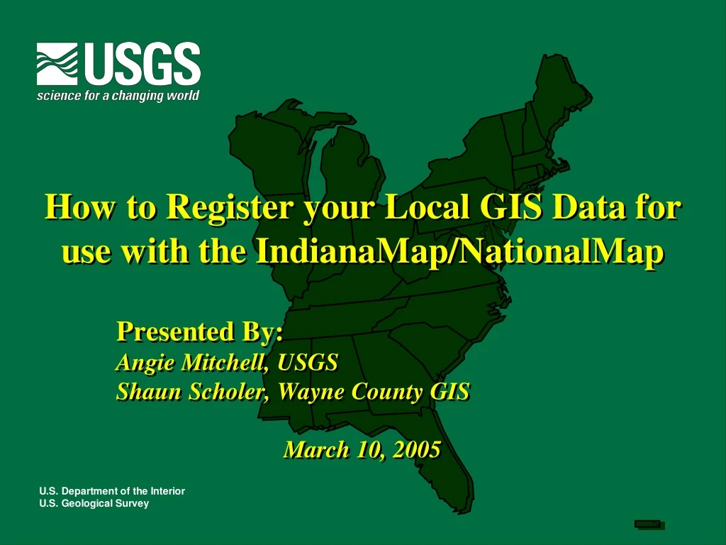
The Local Government Perspective Shaun Scholer, Wayne County GIS
What's in it for YOU! • Integrate map data • Federal • State • Neighboring local government • Desktop applications running WMS plug-in • No more coping data • Broaden your user base
What’s Required? • Web Service • ArcIMS - ESRI • MapGuide - Autodesk • WebMap – Intergraph • MapServer – open source • WMS service • Customize map • Metadata