Download
1 / 29
290 likes | 437 Views
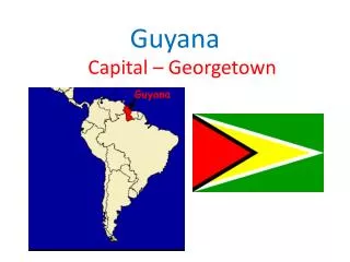
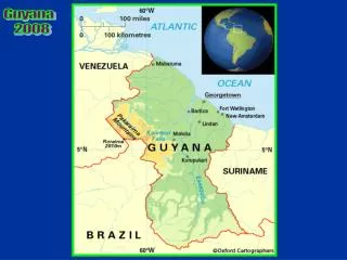
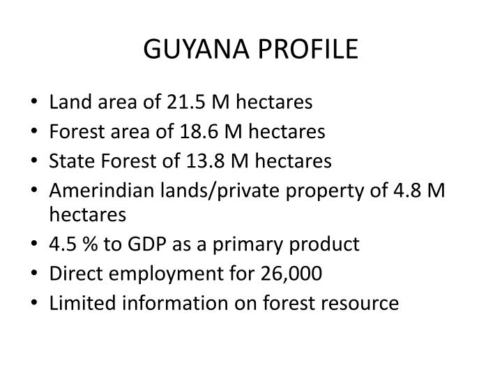
GUYANA PROFILE. Land area of 21.5 M hectares Forest area of 18.6 M hectares State Forest of 13.8 M hectares Amerindian lands/private property of 4.8 M hectares 4.5 % to GDP as a primary product Direct employment for 26,000 Limited information on forest resource. GUYANA PROFILE.

E N D
GUYANA PROFILE • Land area of 21.5 M hectares • Forest area of 18.6 M hectares • State Forest of 13.8 M hectares • Amerindian lands/private property of 4.8 M hectares • 4.5 % to GDP as a primary product • Direct employment for 26,000 • Limited information on forest resource
GUYANA PROFILE • Information available is fragmented • Need to consolidate information • Need to urgently undertake scientific studies to collect strategic information relevant to REDD and other initiatives • REDD template useful in giving guidance on preparing a logical flow of strategies/activities • Process followed to date has been very rewarding
Component 1: Land use, forest policy and governance quick assessment • No national approach to assess forest carbon stock • Lots of policy documents, harmonization with other legislation needed • Main drivers of deforestation and forest degradation identified • Many organizations have governance responsibility over land use options
COMPONENT 2: Management of Readiness • REDD Secretariat established; housed within GFC • Reports to the GFC; NCC, OP • Collaborating parties: • Office of the President (policy, oversight) • Ministry of Education (Planning/coordination) • Ministry of Amerindian Affairs (Local indigenous communities; land titling/development) • Ministry of Local Government (Regional Planning)
Collaborating Parties to REDD Secretariat • Indigenous Communities and leaders • Private sector organizations (FPA; GMSA, PSC) • Academic institutions (UG; GSA; ) • NGO’s (CI; WWF; Iwokrama) • Guyana Lands and Surveys Commission (land use planning) • Guyana Geology and Mines Commission (Mining)
Collaborating parties to REDD Secretariat • Guyana Energy Agency (Renewable sources of energy; fossil fuels) • Environmental Protection Agency (BD conservation; Protected areas) • Forestry Training Centre Incorporated • Forest Products Development and Marketing Council
Expected impacts of Secetariat • REDD integrated into overall policy of Govt. • GFC is the regulatory/management authority for forests • REDD will be incorporated into forest policy dialogue, land tenure and land use rights, benefit sharing, SFM, through wide stakeholder dialogue • GFC is a member of the multi stakeholder NCC
REDD Consultation and outreach • Vital component of the overall plan • Real consultation, not cosmetic exercise • Sensitization meetings already held with over 30 groups • Plan targets at least 50 outreach meetings in addition to 3 National and 4 Regional workshops
Topics proposed for discussion • REDD and the various aspects of a REDD scheme • Components of the R-PLAN • Forest land, policies, causes of deforestation and forest degradation • Land use rights, land tenure systems • Forest governance and accountability • Interests of indigenous peoples and other forest dependent communities
Topics proposed for discussion • Economic, social and environmental impacts of REDD and mitigation of risks • Gains/losses from REDD activities; benefit sharing of incentives • Current monitoring systems and the need to update them to increase credibility re forests and emissions • Restoration/ rehabilitation of degraded forests
Topics proposed for discussion • Potential for poverty alleviation • Capacity building opportunities for all stakeholders • Opportunity costs: REDD programs versus business as usual; potential increase in commercial logging • Alternatives that are viable/ profitable • SFM; PES …
Outputs /activities for Component 2 • Assessment of current and projected land use options in targeted areas • Identification of alternative land use options • Assessment of expected benefits from options • ID of likely impacts of REDD activities on existing land uses (community, regional, national) • Preparation of a consultation and outreach program to educate/get feedback on the REDD activities.
Component 3: Designing the REDD strategy • Technical Strengthening: Methodology and Measurement • Assessment of historical emissions from deforestation/degradation • Projection and modeling of future emissions • Update biomass field estimates across all land uses • Create a national-level carbon methodology that caters for project-level activities
Methodology and measurement • Develop carbon, biodiversity and social criteria; and spatially explicit datasets to target incentives to the highest outcome potential • Establish national level permanent biomass monitoring plots representative of all geographic regions and forest types; create monitoring plan and protocols • Establish capacity building plan for the above
Methodology and Measurement • Develop a capacity building plan for GIS and remote sensing activities • Create a mechanism to integrate monitoring data at the national level • Increase involvement in key international for a to build support for Guyana’s baseline work • Facilitate exchange and networking with other participants
Demonstration activities • Determine structure for implementation of pilot activities • Community outreach activities • Capacity building for carbon and pilot project activities • Establish criteria for plot evaluation/selection • Launch initial projects as demonstration pilots • Establish annually 2-300 biomass plots
Demonstration activities • Define and implement socio-economic monitoring plans • Analysis and testing of alternatives that address each driver of deforestation and forest degradation wherever possible
Component 3: Designing a REDD strategy • Expected outcomes • Forest carbon stock baseline established • Model for reference scenario developed • Systems for updating biomass field estimates developed • Methodology for national biomass monitoring system established • Structure for the implementation of pilot activities developed
Component 4:REDD Implementation Framework • Institutional frameworks developed to address key REDD issues namely: • Carbon ownership across different management and tenure arrangements • Implementation of National and project based carbon accounting and registry capabilities • Carbon valuation, marketing and negotiating • Transparent benefit sharing arrangements for REDD based financial incentives
Component 5: Social and Env. Impacts; potential additional benefits of candidate REDD strategy activities • Review of all policies governing forestry as well as related policies on resource management and conservation • Conduct appropriate meeting with stakeholders • Assess the health of forests within the selected project areas • Assess the impacts of REDD strategy activities on the environment
Component 5 • Analysis of the compatibility of the proposed activity with existing land uses in and around selected project areas • Consider alternatives as well as the “business as usual” approach and make proposals • Prepare recommendations/timelines to mitigate any negative impacts that may arise out of the alternatives
Component 6: Assess investment and capacity building requirements • Conduct investment assessment of national and community level needs to engage in REDD activities • Execute training programs through FTCI/ NGO’s /Iwokrama to build capacity in the “identified gaps”. Consultation to be done with the target groups on the preferred mode of training • Provide incentives to the private sector to invest in sustainable economic and employment opportunities. • Establish transparent mechanisms for the above
Component 7: Establish a reference scenario • Establish historical map information • Review and document allometric equations and expansion factors available for volume, biomass and carbon • Use vegetation maps of forest types (1970-72; 1990-94) and current inventory data to determine volume and biomass components for each forest type • Use GFC production data of timber harvesting from 1950 to present to formulate datasets
Component 7 • Use growth and yield models and post harvest survey information to estimate forest degradation • Obtain national statistics on population, per capita income and other indicators to estimate rates of national timber use for housing, investment. Review all available information on mining, agricultural conversion lands etc.
Component 7 • Use the information gathered to develop projection models re future rates of emissions that are based on sound scientific rationale. • Subject these models to international review and based on feedback, finalize the Guyana REDD reference scenario and policy evaluation model
Component 8: Design and implement Monitoring, Reporting and Verification system for REDD • Develop a software tool to routinely process and compare satellite images, producing vectorized maps and tables of forest cover and cover change • Establishment of a network of permanent biomass monitoring plots, together with data systems and a cadre of trained staff • Undertake fieldwork and analysis to refine allometric models and functions and provide as far as is possible Tier 3 functions for all models
Component 8 • Linkages established to GFC Production database, GEMFORM forest planning database and forest management plan maps so that all forestry activities are immediately summarized and reported within the system • Interagency agreement on the standardization of satellite imagery and protocols • Study tours, training, best practices
Component 8 • Once system is operational, the following activities become routine: • Annual acquisition and processing of satellite imagery • Annual re measurement of permanent plots • Running of integrated software to produce all maps and output tables required • External audits to guarantee credibility of system
Component 9: Design a system of management, implementation and evaluation of Readiness preparation activities • REDD secretariat establishment • Will coordinate the preparation of monitoring and progress reports according to the system required by FCPF and others • All REDD activities will be appropriately coded in the financial system to enable the preparation of all required reports