Download
1 / 23
230 likes | 361 Views
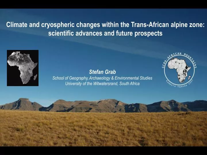
Climate and cryospheric changes within the Trans-African alpine zone: scientific advances and future prospects. Stefan Grab School of Geography, Archaeology & Environmental Studies University of the Witwatersrand, South Africa. Objectives:.

E N D
Climate and cryospheric changes within the Trans-African alpine zone: scientific advances and future prospects Stefan Grab School of Geography, Archaeology & Environmental Studies University of the Witwatersrand, South Africa
Objectives: • To briefly review high altitude African mountain research • focusing on: • -climate • -cryosphere • - To identify potential research gaps • - To review recent initiatives aimed at developing African • Mountain research S. Grab
Rationale – why focus on African mountain climates ‘observed changes in freezing-level height are related to a long-term increase in sea surface temperatures in the tropics…..tropical environments may be particularly sensitive because the changes in tropical sea surface temperature and humidity may be largest and most systematic at low latitudes’ (Diaz & Graham, 1996, Nature) Significance of African Mountains (with re to climate) -High tropical representation -Extensive latitudinal representation -Storehouses of climate change -Refuge sites (human habitation, fauna & flora) -Important water reservoirs in a drought prone continent S. Grab Climate change is impacting African mountain systems: Cryosphere – hydrology – ecosystems – economies - vulnerabilities
What do we know? Climate of Simen (detailed measurements during the late 1970’s by Hurni Climate of Bale (detailed measurements/descriptions by Miehe & Miehe (1994); contemporary monitoring. Contemporary macro-scale seasonal climate forecasting work (e.g. Gissila et al., 2004) Long-term rainfall trends for highlands since ca. 1897 (highest station = 2750m)(Osman & Sauerborn, 2002) Quaternary climate change - based on proxy records (e.g. pollen) Ethiopian Highlands Ras Dejen (4620m) S. Grab 1:100000 Hurni & Messerli, 1980: Institute of Geography, Univ. of Berne
Ethiopian Highlands • What is required? • Archival based research for climate and cryogenic changes during historical times • Evidence for past permafrost = ? • Timing of deglaciation in different regions = ? • Installation of atmospheric and ground climate monitoring stations in high mountain regions (Simen, Bale etc) • Satellite based research (e.g. for monitoring contemporary snow & cloud cover) Saneti Plateau – Bale Mnts S. Grab Dejen Escarpment – Simen Mnts S. Grab
Mt Kenya • What do we know? • Early 1900 descriptive climate and glacier records. • Extensive work on sedimentary chronologies (moraine and lake sediments)(e.g. Mahaney 1970’s – 1980’s) • Radiocarbon-dated lacustrine sed. sequences & oxygen isotope records = high resolution chronology of glacial advances / moisture balances during the Holocene (e.g. Karlén et al, 1999; Baker et al., 2001). • Regular glacier surface area / mass balance reports since 1980’s (esp Hastenrath) • Glacier reviews (e.g. Mahaney, 1989; Hastenrath, 2005) • Periglacial phenomena documented (including rock glaciers)(e.g. Hastenrath, Grab)
Mt Kenya • What do we know….cont? • High mnt atmospheric and ground climate studies (Winiger 1981; Grab et al., 2004). • 1980’s onwards – CDE, Univ. Berne group agro climate & hydro studies - plateau region around Mt Kenya. • 1990’s onwards Global WMO/GAW station at 3678m (MeteoSwiss & Kenya Met. Dept) – for standard meteorological data, CO & O3 monitored since 2002.
Tyndal glacier (2004) Mountain Club of Kenya In: Hastenrath, 2005 Tyndal glacier (1919) (Arthur, 1921)
World Glacier Monitoring Service (WGMS) has been published at 5 year intervals since 1959 Mt Kenya has had a 67% ice reduction between 1899-1993 (WGMS, 1998)
Global WMO/GAW station Mt Kenya (3678m) Mt Kenya • What is required? • Ensure continued climate monitoring at 3678m & 4200m. Reestablish the 4700m station near Point Lenana, adjacent to Lewis glacier. • Borehole temperature monitoring. • Detailed monitoring of Lewis glacier during its last phase of existence. • Constraints: Vandalism/theft S. Grab Global WMO/GAW station Mt Kenya (4200m) S. Grab
Kilimanjaro • What do we know? • Early 1900 descriptive climate and glacier records. • Limited work on sedimentary chronologies (moraine)(e.g. Mahaney) • Very limited periglacial research (possibly 2 or 3 papers during 1970’s) • Regular glacier surface area / mass balance reports and reviews: from sketch maps, photos, tacheometry (late 1950’s) to aerial photogrammetry and Landsat Images (1980’s onwards) (e.g. Klute, Hastenrath, Osmaston, Kaser et al.) • Ice Core records and Holocene glacial chronology (Thompson et al.)
Kilimanjaro • What do we know…..cont? • 2000 onwards = continuous climate monitoring on northern Icefield (Hardy et al.) Chan et al., 2007: Intraseasonal precipitation variability on Kilimanjaro and the East African region and its relationship to the large-scale circulation, Theor. Appl. Clim. • Recent & current research programmes on solar radiation modeling, ice-radiation geometry, volcanic interference, historical glacier cover change (Kaser et al.) • Volcanic activity (fumeroles/sulphur emissions) may have increased since late 1800’s.
Kaser et al. 2004 Source: http://www.geo.umass.edu/climate/tanzania/jan07.html
Kilimanjaro Fumerole • What is required? • Ensure continued climate monitoring at the summit and at lower altitudes. • Establish presence, distribution & characteristics of permafrost. • Bore hole temperature recording to 2m depths for possible CALM site (Circumpolar Active Layer Monitoring)(proposal submitted by Palacios & Grab) • Record periglacial phenomena and processes • Monitoring geothermal activity (understanding geothermal heat sources) • Establishing multicentury ice cap histories (Kaser & team) S. Grab
Ruwenzori – Virunga (Albertine system) • What do we know? • Ruwenzori – commentary on glaciers discussed occasionally 1950’s – Heinzelin 1950’s-1960’s – Whittow, Osmaston 1970’s- mid 1990 – apparent gap 1996 – review by Kaser & Noggler post 2000 – ongoing + implications on hydrology (Kaser team, Taylor team, Italian team, Eggermont team • Limited climate data: Kabale (1867m) Karisoke Research Centre (3100m): 1979 onwards Sabinyo (Rurambo, 2500m) & Kinigi (2200m): data for limited years Ruwenzori (current monitoring) • Historical documents (early 1900’s) describe environmental conditions. • Virunga – several early reports commenting on the snows of Karisimbi ‘It is…..nearly always snow-covered.’ (Jack, 1913) ‘….and the snow-capped crest of Karisimbi, ….’ (Philipps, 1923) • Virunga – no reports on glaciation/periglaciation Alexandra (5109m) Dave Van Smeerdijk
Ruwenzori – Virunga (Albertine system) • What is required? • Ruwenzori – ongoing glacier work (Kaser, Italian groups, Eggermont et al.) • Establish periglacial phenomena and processes (permafrost?) • Establish CALM sites (if premafrost is present) • Establish additional atmospheric and ground climate monitoring at high altitudes ( Karisimbi & elsewhere?) • Establish status of previously installed weather stations. • Establish historical climate change in Ruwenzori (last 140 yrs – Taylor) Dave Van Smeerdijk
Drakensberg – Maluti system • What do we know? • Substantial cryogenic (periglacial & glacial) research since the mid 1930’s (ca. 70 publications) • Several short term weather recording projects (Grab, Killick, Nel, Sumner etc) • Mountain climatology research from 1960’s onwards (Freiman, Grab, Nel, Tyson etc) • Current project on historical climate change (last 160 years) based on archival records (Nash, Grab) • Recent (2000 onwards) satellite and radar based climate studies (Snow distribution patterns, rainfall patterns etc) (Grab et al.) • Current project on snow mapping for risk assessment and disaster risk reduction (Grab, Linde)
Drakensberg – Maluti system • What is required? • High resolution / high precision palaeo-climate verification. Proposal to do cosmogenic dating and ostrachod work on recently (2007) discovered palaeo-lake sediments (Carr, Mills, Grab, Horne) • Establish permanent climate observatories. S. Grab Constraints: vandalism / theft
Establishing a Network of High Altitude Climate Observatories in African Mountains - progress thus far: The ‘Global Change Research Network in African Mountains’ (GCRN-AM) was launched in July 2007, Kampala, Uganda: MRI, Global Mountain Program, African Highland Initiative et al. Established working groups: Climate change Land use / land cover change Livelihoods / decision making biological systems
Establishing a Network of High Altitude Climate Observatories in African Mountains - progress thus far: Planning workshop on establishing high altitude observatory systems in Ethiopia, January 2008, Addis Ababa, Ethiopia: Working group established (Grab, Zeleke et al.) Possible observatory sites discussed Concept proposal has been drafted Next phase: comprehensive proposal to be written for potential funding.
Concluding remarks • Geophysical research outputs and current needs are highly • variable across the respective African mountain regions • Emerging requirements: • To develop a database for past geophysical research outputs and current programmes • To identify high priority monitoring regions • To establish regional monitoring networks: • - Installation of standardized weather stations, borehole probes • - Links with GCOS (Global Climate Observing System) and GTN-G (Global Terrestrial Network for Glaciers)