Download
1 / 1
20 likes | 232 Views
The role of seismic tomography for the Earthquake Early Warning system Smaglichenko Tatyana ¹ Gorbatikov Andrey ² Nikolaev Alexey ² and Smaglichenko Alexander ²

E N D
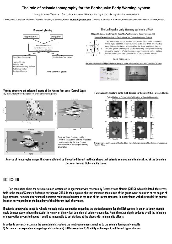
The role of seismic tomography for the Earthquake Early Warning system SmaglichenkoTatyana ¹ Gorbatikov Andrey ² Nikolaev Alexey ² and Smaglichenko Alexander ² ¹ Institute of Oil and Gas Problems, Russian Academy of Science, Russiakrutas39@yahoo.com ² Institute of Physics of the Earth, Russian Academy of Science, Moscow, Russia, Analyze of tomography images that were obtained by the quite different methods shows that seismic sources are often localized at the boundary between low and high velocity zones DISCUSSION Our conclusion about the seismic source locations is in agreement with research by Rebetskiy and Marinin (2006), who calculated the stress field in the area of Sumatra-Andaman earthquake 2004. In their opinion, the first motion in the source of the great event occurred at the region of high stresses. However afterwards the seismic radiation culminated in the zone of the lowest stresses. In accordance with their model the source location corresponded to the boundary of the different level of stresses. If seismic tomography image is reliable we could make assumption regarding the station locations for the EEW system. In order to timely warn it could be necessary to have the station in vicinity of the critical boundary of velocity anomalies. From the other side in order to avoid the influence of observation errors to images it could be reasonable to set stations at the places with minimal site effects. In order to correctly estimate the evolution of structure the next requirements must be to the seismic tomography results 1) Accurate correspondence to geological structure 2) 100% resolution; 2) Stability with respect to different types of error