Download
1 / 9
90 likes | 237 Views
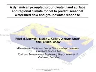
Dominguez Channel Watershed Pollutant Transport and Total Maximum Daily Loads: Modeling, Analysis, and Outreach. Principal Investigators: Norman L. Miller 1 and Reed M. Maxwell 2 1 Lawrence Berkeley National Laboratory, Earth Sciences Division, CA Water Resources Res. & App. Center

E N D
Dominguez Channel WatershedPollutant Transport and Total Maximum Daily Loads: Modeling, Analysis, and Outreach Principal Investigators: Norman L. Miller1 and Reed M. Maxwell2 1 Lawrence Berkeley National Laboratory, Earth Sciences Division, CA Water Resources Res. & App. Center 2 Lawrence Livermore National Laboratory, Geosciences & Environmental Technologies Division
Goals: • Implement, Evaluate, and Apply the Hydrologic Simulation Program - FORTRAN (HSPF) to the Domiguez Channel Watershed, improve parameterizations, and study the HSPF at the process level (LBNL and SCCWRP). • Improve available input precipitation estimates using geospatial techniques (LBNL). • Develop a coupled atmosphere-land surface-ground water-harbor circulation model to understand hydrologic cycling at the Dominguez Channel Watershed (LBNL and LLNL). • Develop pollutant transfer modeling within the coupled model for application as a tool for determining future TMDLs (LBNL, LLNL, SCCWRP). • Provide educational outreach to stakeholders and policy-makers for understanding watershed and pollutant transport processes and modeling concepts (SCCWRP, LBNL, LLNL).
Year 1:This research and applications project has several phases of basic research, development, testing, applications, and outreach • Implement, Evaluate, and Apply the Hydrologic Simulation Program in FORTRAN (HSPF) to the Domiguez Channel Watershed and study the HSPF at the process level. • Begin simulations using historical forcing data • Perform uncertainty analysis on HSPF • Generate optimized parameter space • Obtain nearby precipitation and temperature observational records, fine-scale Digital Elevation Model (DEM) data, and large-scale “Reanalysis” for research and application of a geospatial model for fine-scale precipitation and temperature. • Couple the LSM (Land Surface Model, 100-1000m) with PARFLOW (Parallel groundwater flow model, 10m) with grid matching and mass/energy conservation across the interface. • Generate a a proof-of-concept simulation with synthetic data for parameterization and forcing to show. • Design land use category representing the Domiguez Channel runoff as a sub-grid model component. • Present our conceptual rationale, methods, expected results in the August Stakeholders Meeting. Interact with the local community and stakeholders on TMDL issues.
Coupled Atmosphere-Land Surface- Groundwater-Near Shore Circulation ModelThis multi-year research and applications project has several phases of development, testing, basic research, applications, and outreach Year 2: • Continue to evaluate the processes within HSPF. • Begin a sequential set of model studies: • Coupled Land Surface - Groundwater with available data. • Coupled Atmosphere - Land Surface with an HSPF-like urban subgrid • Coupled Land Surface -Near Shore Circulation - Groundwater • Study transient stresses of one model component on another. • Obtain bore hole data to generate a 3-D description of the Dominguez Channel Watershed subsurface. • Begin development of a Near Shore Circulation model • Begin pollutant transport modeling within the coupled system. • Prepare and deliver educational seminars to DCWAC, regulatory and petroleum industry organizations and other stakeholders on hydrologic cycle processes and basic modeling concepts related to the Domiguez Channel Watershed and pollutant transport.
Coupled Atmosphere-Land Surface- Groundwater-Near Shore Circulation ModelThis multi-year research and applications project has several phases of development, testing, basic research, applications, and outreach Year 3: • Couple Atmosphere-Land Surface-Groundwater-Near Shore Circulation and begin a 30 year simulation to understand flow paths, fluxes, storage, and residence times. • Perform a coupled Land Surface-Groundwater-Near Shore Circulation with pollutant and one-way coupled version of HSPF to study pollutant sources, sinks, and storage, and residence times with input from observations. • Prepare a technology transfer for application to other watersheds where groundwater processes are more significant. • Give seminars to DCWAC, regulatory and petroleum industry organizations and other stakeholders on hydrologic cycle processes, and basic modeling concepts and uncertainties related to the Domiguez Channel Watershed and pollutant transport. • Publish scientific finding in peers reviewed journals.
Coupled Atmosphere-Land Surface- Groundwater-Near Shore Circulation ModelThis multi-year research and applications project has several phases of development, testing, basic research, applications, and outreach Year 3: • Couple Atmosphere-Land Surface-Groundwater-Near Shore Circulation and begin a 30 year simulation to understand flow paths, fluxes, storage, and residence times. • Perform a coupled Land Surface-Groundwater-Near Shore Circulation with pollutant and an off-line version of HSPF to study pollutant sources, sinks, and storage, and residence times with input from observations. • Prepare a technology transfer for application to other watersheds where groundwater processes are significant. • Give seminars to DCWAC, regulatory and petroleum industry organizations and other stakeholders on hydrologic cycle processes, and basic modeling concepts and uncertainties related to the Domiguez Channel Watershed and pollutant transport. • Publish scientific finding in peers reviewed journals.
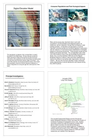
Troposphere Moisture Advection Precipitation Evapotranspiration Boundary Layer Evaporation Overland Flow Surface Recharge Discharge Infiltration Variable Groundwater Table Shallow Zone Deep Zone Water Cycling
Recharge Zones Discharge Zones