Download
1 / 10
100 likes | 294 Views
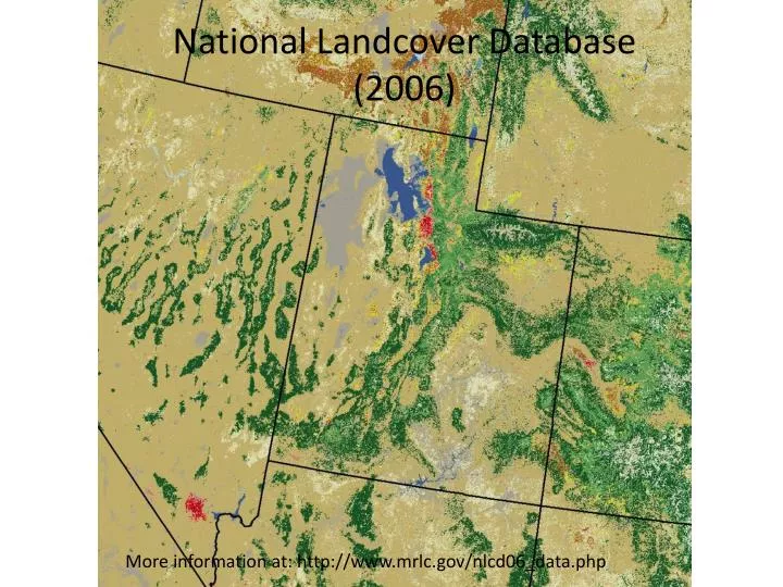
National Landcover Database (2006) More information at: http://www.mrlc.gov/nlcd06_data.php. NLCD 33 category (1 sec). USGS 19 category (30 sec) . Addition of Playa, White Sand, and Lava categories for WRF modeling over military test ranges. How to change landuse.

E N D
National Landcover Database (2006) More information at: http://www.mrlc.gov/nlcd06_data.php
NLCD 33 category (1 sec) USGS 19 category (30 sec)
Addition of Playa, White Sand, and Lava categories for WRF modeling over military test ranges
How to change landuse Get landuse_1s_westconus_playa folder from Jeff and put it in your geog/ directory, includes crucial index file In WPS/geogrid, add to GEOGRID.TBL an interp option and rel_path for the new dataset under LANDUSEF In geogrid/src/source_data_module.F, change min_category=1 and max_category=33 in subroutine get_max_categories then recompile In namelist.wps change the geog_data_res to the rel_path you set in GEOGRID.TBL In WRFV3/run directory copy in Jeff’s VEGPARM.TBL and LANDUSE.TBL that have 33 categories In namelist.input add in num_land_cat=33 under &physics Contact Jeff with issues
Added new variable BB - B parameter, used to calculate hydraulic conductivity DRYSMC - Soil moisture threshold when evap stops MAXSMC – Soil porosity REFSMC – Soil moisture threshold when ET beings to stress SATDK – Saturated soil conductivity SATDW – saturated soil diffusivity WLTSMC – Wilting point of vegetation QTZ – Soil quartz content
How to add new variable to lookup table Easy! Call CLYC in subroutine REDPARM in Noah LSM
SHDFAC – green vegetation fraction NROOT – number of soil layers roots penetrate RS – stomatal resistance RGL – parameter used for radiation stress function HS – parameter used in vapor pressure deficit function SNUP – snow depth (in m of water equivalent) that implies 100% snow cover
SHDMAX – maximum monthly vegetation cover from GREENFRAC variable initialized in met_em files SHDMIN –Mimimum monthly veg cover Vegetation categories may take max lookup table values, min values, or somewhere in between
Playa fixed at 0.46 Shrubland varying between 0.25 and 0.3
LANDUSE.TBL not used by Noah or RUC LSM. Values initialized in module_physics_init.F are overwritten by VEGPARM.TBL values