Download

1 / 24
240 likes | 347 Views
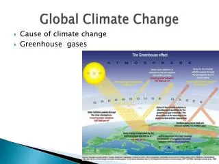
METR112 Global Climate Change -- Lecture 2 Energy Balance (2). Prof. Menglin Jin San Jose State University. Arctic sea ice coverage, 1979 and 2003 NASA http://www.learner.org/channel/courses/envsci/unit/text.php?unit=12&secNum=7. The Earth is not warming uniformly .

E N D
METR112 Global Climate Change -- Lecture 2 Energy Balance (2) Prof. Menglin Jin San Jose State University
Arctic sea ice coverage, 1979 and 2003 NASA http://www.learner.org/channel/courses/envsci/unit/text.php?unit=12&secNum=7
The Earth is not warming uniformly. • Notably, climate change is expected to affect the polar • regions more severely: • The Arctic is warming nearly twice as rapidly as the rest of the world; • winter temperatures in Alaska and western Canada have risen by up to 3–4°C • in the past 50 years, and • Arctic precipitation has increased by about 8 percent over the past century • (mostly as rain) Less snow Smaller albedo Due to, partly: Positive albedo feedback More insolation in surface Higher surface temperature
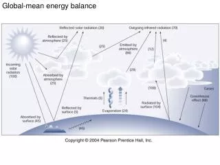
Albedo of Earth • albedois used to representreflectivity of Earth's surface • The term albedo (Latin for white) is commonly used to or • applied to the overall average reflection of an object. • For example, • the albedo of the Earth is 0.39 (Kaufmann 1991 ) and • this affects the equilibrium temperature of the Earth. • The greenhouse effect, by trapping infrared radiation, • can lower the albedo of the earth and cause global warming. This is why albedo is important
Albedo The ratio of the outgoing solar radiation reflected by an object to the incoming solar radiation incident upon it. Earth Observatory GlossaryBy NASA,Responsible NASA official: Dr. Michael D. King,http://earthobservatory.nasa.gov/Library/glossary.php3?mode=all I IIN I OUT IN α = IOUT Dimensionless Range: 0 (dark) – 1 (bright) The word is derived from Latinalbedo "whiteness", in turn from albus "white". Albedo depends on wavelength and is determined by the structural and optical properties of the surface, such as shadow-casting, mutiple scattering, mutual shadowing, transmission, reflection, absorption and emission by surface elements, facet orientation distribution and facet density.
Surface Albedo properties • Form 0-1.0 • Varied with solar zenith Angle • Vary with surface properties (what color soil, if vegetation covered, etc) • Vary with surface roughness • Vary with soil moister
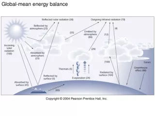
Why Is Surface Albedo Critical? Surface Energy Budget: (1-α)Sd +LWd-εσTskin4 +SH+LE + G= 0 Answer: albedo plays the key role in surface energy balance as it decides how much surface insolation is kept in Earth surface system
This is a black spruce forest in the BOREAS experimental region in Canada. Left: backscattering (sun behind observer), note the bright region (hotspot) where all shadows are hidden. Right: forwardscattering (sun opposite observer), note the shadowed centers of trees and transmission of light through the edges of the canopies. Photograph by Don Deering. http://www-modis.bu.edu/brdf/brdfexpl.html
A soybean field. Left: backscattering (sun behind observer). Right: forwardscattering (sun opposite observer), note the specular reflection of the leaves. Photograph by Don Deering. http://www-modis.bu.edu/brdf/brdfexpl.html
A barren field with rough surface Left: backscattering (sun behind observer), note the bright region (hotspot) where all shadows are hidden. Right: forwardscattering (sun opposite observer), note the specular reflection. Photograph by Don Deering. http://www-modis.bu.edu/brdf/brdfexpl.html
Albedo is function of wavelength. Boradband albedo Spectral albedo – the reflectivity for specific wavelength Boradband albedo is the integrated value of spectral emissivity at all wavelength
0.0 ..................................................................0.25 Shortwave White-Sky Albedo from Aqua and Terra: Level 3, 16-day, one kilometer MODIS BRDF/Albedo Products
An albedo value of 0.0 indicates that the surface absorbs all solar radiation, and a 1.0 albedo value represents total reflectivity. http://theothermy.blogspot.com/2007/12/albedo-and-cool-roofs.html
CMG Broadband White-Sky Albedo (0.3-5.0mm) 14 - 29 September, 2001 0.0 0.2 0.4+ No Data
CMG Broadband White-Sky Albedo (0.3-5.0mm) 1 - 16 January, 2002 0.0 0.2 0.4+ No Data
CMG Broadband White-Sky Albedo (0.3-5.0mm) 18 February - 5 March, 2002 0.0 0.2 0.4+ No Data
CMG Broadband White-Sky Albedo (0.3-5.0mm) 7 - 22 April, 2002 0.0 0.2 0.4+ No Data
White Sky Spectral Albedo 7 - 22 April, 2002 NIR (0.1-0.4)Red (0.0-0.16)Blue (0.0-0.18) No Data
Nadir BRDF-Adjusted Reflectance (NBAR) 7 - 22 April, 2002 NIR (0.1-0.4)Red (0.0-0.16)Green (0.0-0.18) No Data
Surface Reflectance at Near-Infrared Wavelengths • Surface reflectance is high at 2.2 µm, moderate at 0.66 µm, and low at 0.49 µm • The aerosol effect on reflected solar radiation is small at 2.2 µm and large at 0.49 µm • MODIS operational algorithm over land assumes Kaufman et al. (1997) Ag(0.47 µm) = 0.5Ag(0.66 µm) = 0.25Ag(2.1 µm)
Desert Albedo True-color White-sky Spectral Albedo from MODIS Desert albedos are clearly nonuniform, with implications for global climate modeling (Tsvetsinskaya et al., GRL, 2002)
Snow versus Non-snow Albedos 40–50°N Nov 00–Jan 01 Jin et al., How does Snow Impact the Albedo of Vegetated Land Surfaces as Analyzed with MODIS Data?, in press, Geophys. Res. Let., 2002
References • Friedl, M.A., D. Muchoney, D.K. McIver, A.H. Strahler, and J.C.F. Hodges 2000: Characterization of North American land cover from AVHRR Data, Geophysical Research Letters, vol. 27, no. 7, pp. 977-980. • Friedl, M.A., C. Woodcock, S. Gopal, D. Muchoney, A.H.Strahler, and C. Barker-Schaaf 2000. A note on procedures used for accuracy assessment in land cover maps derived from AVHRR data, International Journal of Remote Sensing, vol. 21, pp.1073-1077. • Friedl, M.A., Brodley, C.E. and A.H. Strahler 1999: Maximizing land cover classification accuracies at continental to global scales, IEEE Transactions on Geoscience and Remote Sensing, vol. 37, pp. 969-977. • Friedl, M.A. and C.E. Brodley 1997: Decision tree classification of land cover from remotely sensed data, Remote Sensing of Environment, vol. 61, pp. 399-409. • Mciver, D.K. and M.A. Friedl 2002. Using prior probabilities in decision-tree classification of remotely sensed data, Remote Sensing of Environment, Vol. 81, pp. 253-261. • McIver, D.K. and M.A. Friedl 2001. Estimating pixel-scale land cover classification confidence using non-parametric machine learning methods, IEEE Transactions on Geoscience and Remote Sensing. Vol 39(9), pp. 1959-1968. • Muchoney, D., Borak, J, Chi, H., Friedl, M.A., Hodges, J. Morrow, N. and A.H. Strahler 1999: Application of the MODIS global supervised classification model to vegetation and land cover mapping of Central America, International Journal of Remote Sensing, Vol 21, no 6 & 7, pp. 1115-1138. • Muchoney, D. M., and Strahler, A. H., 2001, Pixel and site-based calibration and validation methods for evaluating supervised classification of remotely sensed data, Remote Sens. Environ., in press.