Download
1 / 18
180 likes | 350 Views
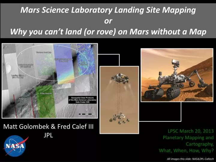
Mars Science Laboratory Landing Site Mapping or Why you can’t land (or rove) on Mars without a Map. Matt Golombek & Fred Calef III JPL. LPSC March 20, 2013 Planetary Mapping and Cartography, What, When, How, Why?. All images this slide: NASA/JPL-Caltech. Landing Sites on Mars. Phoenix.

E N D
Mars Science Laboratory Landing Site MappingorWhy you can’t land (or rove) on Mars without a Map Matt Golombek & Fred Calef III JPL LPSC March 20, 2013 Planetary Mapping and Cartography, What, When, How, Why? All images this slide: NASA/JPL-Caltech
Landing Sites on Mars Phoenix VL2 VL1 MPF Curiosity Opportunity Spirit Elevation Matters – Amount of Atmosphere to Slow Down All Sites at Low Elevation Latitude Matters – Solar Power; Thermal/power Target Materials (e.g., ice) MOLA is Base Map Cartographic & Inertial Frames
MSL Science and Safety Constraints: MSL Safety Criteria MSL Science Criteria Remove these constraints 1 m to 1000 m <100 m <25° 0.5% CFA <7% Golombek, Landing Site Selection
DEMs • Complete CTX DEM Coverage for Radar Interactions • 5-6 HiRISE DEMs to Cover Ellipse • Kirk et al. [2011] • Complete Slope Map (1-5 m) • HiRISE • 1 m/elevation postings • CTX • ~20 m/elevation postings • HRSC • 50 m/elevation postings • Gwinner et al. [2010] Hierarchical co-registration Kim & Muller [2009] PSS
CTX DEM Example CTX DEM 25 m/elevation posting for Radar Interaction Complete Coverage of Ellipse
Gale 1 m Slope Map Touchdown Stability Trafficability
South VL2 PSP_1501_2280 HiRISE Changed Everything Can See Rocks Directly in HiRISE Correlate Large Rocks in HiRISE with those Seen from Lander at All Landing Sites Measure same size-frequency distribution at surface; follow models from surface VL2 400x400 pixels 124x124 meters 1.5 hectares Golombek et al. Rocks Golombek et al. [2008] North
Gale Rock Map Size-Frequency Distribution Rocks in 450 m bins Fit to Model Size-Frequency Distribution for Cumulative Fractional Area from 1 - 40% Calculate Probability of Success for All Rock Sizes Rocks and Slopes- Touchdown Simulations Golombek, MSL Data Products Golombek et al. [2012]
Thermal Inertia Gale Thermal Inertia Material Properties Fergason et al. [2012]
Surface Materials Gale Crater Blue: Unconsolidated eolilanbedforms Green: Eolian thin cover over indurated alluvium Yellow: Indurated alluvium Red: Indurated or cemented flat-lying unit Fergason et al. [2012] Surface Material Properties
Gale Potential Inescapable Hazards Blue=Crater Pink=Mesa *=Probably Escapable **=Inescapable Golombek et al. [2012]
Gale ID. 17** • Crater, 400 mdiameter • 15 to 30° Slopes • Loose material on interior slopes, bedforms on floor • 232084 m2 • 137.548, -4.463 • Inescapable • Coverage shows >15 ° slopes and loose material around entire crater interior • No obvious egress route • Bedforms are likely traversable Only 2 Inescapable Craters Cover 0.13% of Ellipse Golombek et al. [2012]
Gale Crater “Go To” Traversabilty Cratered Plains – No obvious Mobility Concerns Dark Dunes Appear Fresh Many Exceed 30° Mobility Impediment Sample Strata Here Drive up Canyon Here Can Access Mineral Strata in CRISM Can drive up mound
Gale Traverse Routes From Topography Rocks & Material Properties Paolo Bellutta In Golombek et al. [2012]
Overview of Dunes Golombek et al. [2012]
SW Routes Through Dunes Golombek et al., MSL Data Products Golombek et al. [2012]
Traverse Routes in Lower Mound Clay layer Clay layer First fence First fence Canyon 2 Canyon 2 Second fence Second fence Canyon 1 Canyon 1 Not Fan Not Fan Golombek et al., MSL Data Products
This completes the M. Golombek portion of the presentation. The presentation by F. Calef will be added to this and posted at a later date. (2013 April 2)