Download
1 / 12
120 likes | 228 Views
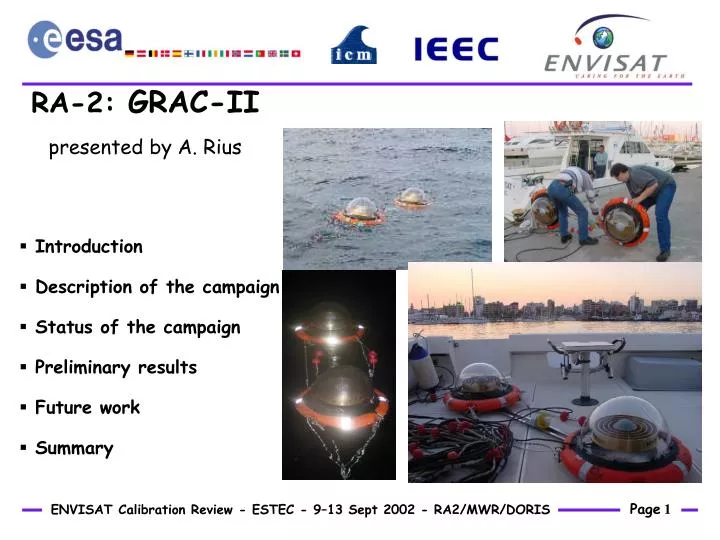
RA-2: GRAC-II presented by A. Rius. Introduction Description of the campaign Status of the campaign Preliminary results Future work Summary. Introduction. GRAC-II: G PS R adar A ltimeter C alibration using light buoys. Partners: IEEC and ICM. Measuring:

E N D
RA-2: GRAC-II presented by A. Rius • Introduction • Description of the campaign • Status of the campaign • Preliminary results • Future work • Summary
Introduction • GRAC-II: GPS Radar Altimeter Calibration using light buoys. • Partners: IEEC and ICM. • Measuring: • Instantaneous absolute sea level on the ENVISAT footprint. • Principle: • Deployment of light buoys provided with GPS antennas, within an ENVISAT footprint area and during the pass of the satellite.
Description of the campaign: THE BUOY • Small and light to follow the sea surface. Easy deployment. • 2-antennas at fixed distance for checking purposes. • 1Hz time series of the position of the antenna phase center. Floatation line of the system already calibrated. • Double frequency GPS observations to correct the ionospheric delay.
Description of the campaign: AREA • West Mediterranean Sea • Measurement points at 15-20 km offshore (GPS processing purposes). • 10 tracks covered: the buoy is deployed on each track every ENVISAT pass, during 6 months.
Description of the campaign: SINGLE EXPERIMENT • Temporal ground station: 4 hours, 2-frequency, 1Hz, phase and code observations • Buoy: • 15-20 km offshore, within 1km radii ENVISAT nominal point. • 30-50 m from boat. • Free floating. • 3 hours, 2-frequency, 1Hz, phase and code observations.
Description of the campaign: PRODUCTS • Primary product: 1 Hz time series position of each buoy, processed independently (GOAII), geodetic height corrected for floating line. Using WGS84 r.e. • Derived Products: • 15-minute averaged sea level as measured by each buoy (average time window centered at ENVISAT pass), and the mean of 2 buoys. • RMS of the sea level, for each buoy (‘apparent’ sea roughness). • Internal checking products. • (…)
Current Status • Started in April 9 2002. • September 4:
Preliminary Results: PRECISION • Formal uncertainty of 1Hz positioning: <3cm • From internal check products: • Postfit residuals of phase observables: <1cm • Distance between buoys: 1cm agreement • RMS of the distance time series: 3cm • Difference between the 15-minute sea level solution obtained from each buoy: <4cm • Difference in the ‘apparent’ sea roughness (vertical position RMS): <1cm
Coarse estimation of the accuracy by comparison with ERS 6-month historical data (blue squares). GPS buoy solutions, corrected for the inverse barometer effect (green and red). Discrepancy within the dispersion. Effect of the current treatment of the tropospheric delay? Preliminary Results: ACCURACY
Future Work • To finish the campaign plan, to 45 experiments. • To process the GPS data to obtain the whole set of time series. • To further investigate the best way to treat the tropospheric delay and how effects the final accuracy (improving the GPS processing, if needed). Idem for post-processing averaging strategies. • To better check of the accuracy of the solution by comparison w.r.t. MSL values, using IB and tide corrections to the GPS data.
Summary • Plan of 45 campaigns to measure the instantaneous sea level, simultaneous to the ENVISAT pass and on its footprint. Using light GPS 2-buoy system. • 35 campaigns already performed, covering 10 tracks along the West Mediterranean Coast. • 22 campaigns processed with GOAII. • Tiny formal error of the solution. Precision as estimated by several different internal checks is of the order of 1-4 cm. • Effect of the current treatment of the tropospheric delay into the accuracy of the solution? To be further investigated. • Averaging strategies?