Download
1 / 17
170 likes | 383 Views
Urbanization and Land Cover Change in Dakota County, Minnesota. Kylee Berger and Julia Vang FR 3262 Remote Sensing Section 001/002. Objectives. Locate the land cover changes, per pixel, in Dakota County, MN from 1984 to 2005

E N D
Urbanization and Land Cover Change in Dakota County, Minnesota Kylee Berger and Julia Vang FR 3262 Remote Sensing Section 001/002
Objectives • Locate the land cover changes, per pixel, in Dakota County, MN from 1984 to 2005 • Determine the relationship between urban growth, agriculture and vegetation.
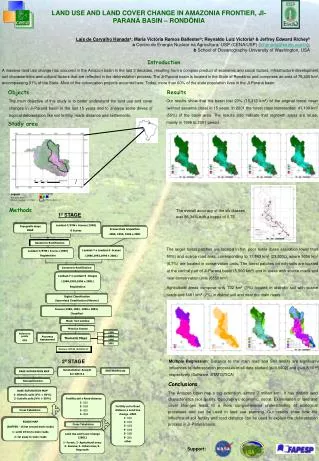
Area of Study Dakota County, Minnesota
Materials, Tools, and Data • Landsat TM images • 1984 • 2005 • MN Data Deli • ArcGIS • ERDAS Imagine 2011 • Dakota County GIS
Methodology • In ERDAS- changed Landsat imagery to UTM zone 15 N • In ERDAS- clipped Dakota county out of our twin cities Landsat images • Ran supervised classification on both 1984 and 2005 images • Ran Thematic Change detection • “From-to” detection • Imported to Arc GIS to display where the changes between the years occurs using transparency • Performed accuracy assessment of both images
Classification • Supervised classification • 20 training points for all 6 Classes • Urban • Agriculture • Water • Wetland • Herbaceous • Forest
Thematic Change Detection • Ran a Matrix Union to find all the changed pixels • Used “Summary Report of Matrix” to see the percent of change and the number of acres that changed • Focused on what classes changed to urban and agriculture
Accuracy Assessment 1984 • Classification Accuracy of 68.6%
Accuracy Assessment 2005 Classification Accuracy Percent of 70.0%
Conclusions • The land use/cover in Dakota County, MN like almost everywhere is being developed into Urban areas and Agriculture fields. • Forests and Herbaceous lands are being developed to support the growing population
Future Studies • Images with less or zero percent cloud cover • Images where dates/years all match up • Better knowledge of programs, images, and study area • Create an error matrix


![A [simple] land cover change intercomparison](https://cdn2.slideserve.com/3941152/a-simple-land-cover-change-intercomparison-dt.jpg)