Download

1 / 18
180 likes | 201 Views
GLOBAL POSITINING SYSTEM WORKING,ERRORS AND CORRECTION USING DGPS. Department Of Electronics and Communication Engineering. OBJECTIVE: To overcome the drawbacks in Global positioning system by implementing Differential global positioning system. INTRODUCTION :

E N D
GLOBAL POSITINING SYSTEM WORKING,ERRORS AND CORRECTION USING DGPS Department Of Electronics and Communication Engineering
OBJECTIVE: • To overcome the drawbacks in Global positioning system by implementing Differential global positioning system .
INTRODUCTION: • The Global Positioning System (GPS) is a satellite-based Navigation system developed and operated by the US Department of Defense. • GPS Permits land, sea and airborne users to determine their three-dimensional position and time. • This service is available to military and civilian users around the clock, in all weather, anywhere in the world.
GPS ELEMENTS: • GPS has 3 parts. • The space segment consists of 24 satellites, each in its own orbit 11,000 nautical miles above the Earth. • The user segment consists of receivers, which you can hold in your hand or mount in your car. • The control segment consists of ground stations (five of them, located around the world) that make sure the satellites are working properly.
WORKING OF GPS: • The principle behind GPS is the measurement of distance ( "range") between the receiver and the satellites. • The satellites also tell us exactly where they are in their orbits above the Earth • Four satellites are required to compute the four dimensions of X, Y, Z (position) and Time • GPS receivers are used for navigation, positioning, time, and other research.
A Person using Gps in mountains GPS device which is used for navigation A Car consisting Gps to show route maps A Person using Gps to find route in forest
SOURCES OF GPS SIGNAL ERRORS: • Factors that can degrade the GPS signal and thus affect accuracy include the following: • Ionosphere and troposphere delays — the satellite signal slows as it passes through the atmosphere. The GPS system uses a built-in model that calculates an average amount of delay to partially correct for this type of error. • Signal multi path — This occurs when the GPS signal is reflected off objects such as tall buildings or large rock surfaces before it reaches the receiver. This increases the travel time of the signal, thereby causing errors.
Number of satellites visible— the more satellites a GPS receiver can "see," the better the accuracy. Buildings, terrain, electronic interference, or sometimes even dense fog can block signal reception, causing position errors or possibly no position reading at all.
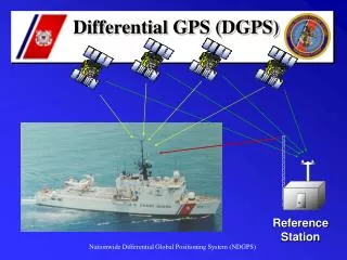
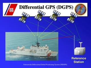
Implementing DGPS: • The three main methods currently used for ensuring data accuracy are • real-time differential correction, • reprocessing real-time data, • post processing. • i.Real-Time DGPS Correction • Real-time DGPS occurs when the base station calculates and broadcasts corrections for each satellite as it receives the data. The correction is received by the receiver.
ii. Reprocessing Real-Time Data GPS manufacturers provide software that can correct GPS data that was collected in real time. If a satellite collecting data can be low on the horizon that it provides only a weak signal, which causes spikes in the data. Reprocessing real-time data removes these spikes and allows real-time data that has been used in the field for navigation iii. Post processing Correction Differentially correcting GPS data by post processing uses a base GPS receiver that logs positions at a known location and a rover GPS receiver that collects positions in the field. The files from the base and rover are transferred to the office processing software, which computes corrected positions for the rover's file.
LIMITATIONS OF GPS: GPS can provide worldwide, three-dimensional positions, 24 hours a day, in any type of weather. However, the system does have some limitations. There must be a relatively clear "line of sight" between the GPS antenna and four or more satellites. Objects, such as buildings, overpasses, and other obstructions, that shield the antenna from a satellite can potentially weaken a satellite's signal such that it becomes too difficult to ensure reliable positioning. These difficulties are particularly common in urban areas. The GPS signal may bounce off nearby objects causing another problem called multipath interference.
APPLICATIONS OF GPS: • GPS receivers were used in several aircraft, including F-16 fighters and B-2 bombers • GPS has become important for nearly all military operations and weapons systems . • GPS is also helping to save lives. Many police, fire, and emergency medical service units are using GPS receivers to determine the police car, fire truck, or ambulance nearest to an emergency, enabling the quickest possible response in life-or-death situations.
Automobile manufacturers are offering moving-map displays guided by GPS receivers and also demonstrating GPS-equipped vehicles that give directions to drivers on display screens and through synthesized voice instructions. • Mapping and surveying companies use GPS extensively. • GPS-equipped balloons are monitoring holes in the ozone layer over the Polar Regions, and air quality is being monitored using GPS receivers.
CONCLUSION: GPS a satellite based navigation system, thus can be used to determine the position of an object on earth. As discussed above, its application field is vast and new applications will continue to be created as the technology evolves.
REFERENCES: SatelliteCommunication-T.PrattandC.W.Bostain-John Wiley and Sons. www.iec.org www.sss-mag.com
Thank you