Download

1 / 20
200 likes | 204 Views
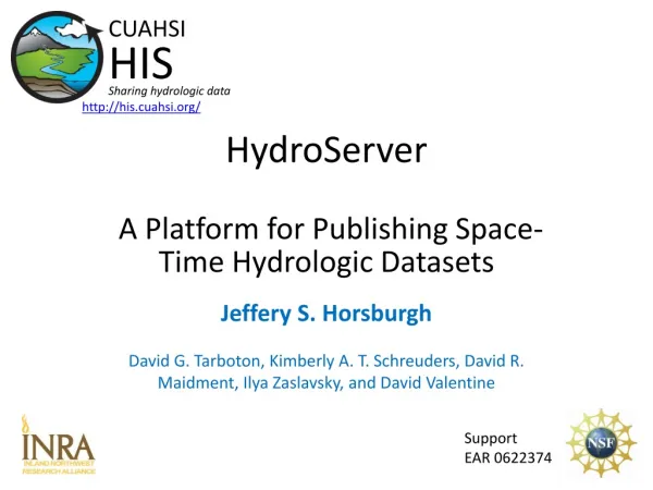
The HydroServer Platform for Sharing Hydrologic Data. David G Tarboton , Jeffery S Horsburgh , Kimberly A. T. Schreuders , David R. Maidment , Ilya Zaslavsky , David Valentine. http://his.cuahsi.org/. CUAHSI HIS Sharing hydrologic data. Support EAR 0622374.

E N D
The HydroServer Platform for Sharing Hydrologic Data David G Tarboton, Jeffery S Horsburgh, Kimberly A. T. Schreuders, David R. Maidment, IlyaZaslavsky, David Valentine http://his.cuahsi.org/ CUAHSI HIS Sharing hydrologic data Support EAR 0622374
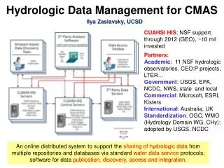
CUAHSI Hydrologic Information System Services-Oriented Architecture Data Discovery and Integration HydroCatalog Search Services Metadata Services WaterML, Other OGC Standards HydroServer HydroDesktop Data Analysis and Synthesis Data Publication Data Services ODM Geo Data Information Model and Community Support Infrastructure
HydroServer – Data Publication Point Observations Data Internet Applications Ongoing Data Collection Historical Data Files ODM Database GetSites GetSiteInfo GetVariableInfo GetValues GIS Data WaterML WaterOneFlow Web Service OGC Spatial Data Service from ArcGIS Server Data presentation, visualization, and analysis through Internet enabled applications
HydroServer Architecture Service Interface Publish point data Publish metadata Publish spatial data Manager Interface Browser Interface HydroServer View server portal WaterOneFlow Web Service Capabilities Web Service Spatial Data Services HydroServer Website WaterOneFlow Web Service WaterOneFlow Web Service Load and Edit data ODM Tools and Data Loaders Observation DataModel View spatial data Geo Spatial Database Map Website Observation DataModel Observation DataModel Spatial Data File HydroServer Capabilities Database Capabilities Configuration Tool Configure server View point data Time Series Analyst Website
Observation Data Model for hydrologic and environmental measurements The way that data is organized can enhance or inhibit the analysis that can be done Groundwater levels Streamflow Precipitation & Climate Soil moisture data Flux tower data Water Quality • A relational database at the single observation level • Metadata for unambiguous interpretation • Traceable heritage from raw measurements to usable information • Promote syntactic and semantic consistency • Cross dimension retrieval and analysis Horsburgh et al., 2008, WRR 44: W05406
Loading data into ODM OD Data Loader • Interactive OD Data Loader (OD Loader) • Loads data from spreadsheets and comma separated tables in simple format • Scheduled Data Loader (SDL) • Loads data from datalogger files on a prescribed schedule. • Interactive configuration • SQL Server Integration Services (SSIS) • Microsoft application accompanying SQL Server useful for programming complex loading or data management functions SDL SSIS
Managing Data Within ODMODM Tools • Query and export – export data series and metadata • Visualize – plot and summarize data series • Edit – delete, modify, adjust, interpolate, average, etc.
Set of query functions ReturnsdatainWaterML WaterML and WaterOneFlow WaterML is an XML language for communicating water data WaterOneFlow is a set of web services based on WaterML
Publication of Spatial (GIS) Datasets • Publishing spatial datasets using ArcGIS Server • Using OGC standards that can be consumed by a number of GIS clients • WMS, WFS, WCS
Data Presentation Via a Map Interface • Internet Map Server built using ArcGIS • Web browser client • Combine spatial data and observational data • Launch data visualization tools • Based on a “Region” http://maps.usu.edu/map/
Data Preview, Visualization, and AnalysisTime Series Analyst • Web Browser Client • Multiple ODM Database Support • Variety of plot types • Descriptive statistics • Linked to the map application • Data preview and download http://icewater.usu.edu/tsa/
HydroServerWebsite • HydroServer home page • Observational data services • GIS data services • Online map • Time Series Analyst • Data Query and Download http://icewater.usu.edu
HydroServer Capabilities Web Service • Publish capabilities of each HydroServer • Listing of published observational data services • Listing of published spatial data services • Supports automatic cataloging of available services at HIS Central • Makes HydroServers self describing Catalog Catalog Services Metadata Services Data Services Server Desktop
Overcoming Semantic Heterogeneity • ODM Controlled Vocabulary System • ODM CV central database • Online submission and editing of CV terms • Web services for broadcasting CVs ODM VariableNameCV Variable Name From Jeff Horsburgh
Dynamic controlled vocabulary moderation system ODM Data Manager ODM Website ODM Tools ODM Controlled Vocabulary Moderator XML Master ODM Controlled Vocabulary Local ODM Database ODM Controlled Vocabulary Web Services Local Server http://his.cuahsi.org/mastercvreg.html From Jeff Horsburgh
Dry Creek Experimental Watershed (DCEW) (28 km2 semi-arid steep topography, Boise Front) A growing collection of HydroServers and community of users • University of Maryland, Baltimore County • Montana State University • University of Texas at Austin • University of Iowa • Utah State University • University of Florida • University of New Mexico • University of Idaho • Boise State University • University of Texas at Arlington • University of California, San Diego • Idaho State University 68 Sites 24 Variables 4,700,000+ values Published by Jim McNamara, Boise State University
Open Development Model http://hydroserver.codeplex.com • user engagement • transparency • collaboration • agility • sustainability • tools
Conclusions • HydroServer provides a self contained data publication system • Self describing (Complete description of data and metadata) • Local control of, and responsibility for data • Downloadable user (data publisher) configurable software stack • ODM and tools, Web service software, Time Series Analyst, ArcGIS server based web map application and map services, HydroServer Capabilities metadata web services • Sharing data in common format can stimulate interdisciplinary collaboration • Growing network of HydroServers will facilitate cross site network scale syntheses Catalog Catalog Services Metadata Services Data Services Server Desktop
Thanks! HIS Project Team and Sponsors • University of Texas at Austin – David Maidment, Tim Whiteaker, James Seppi, Fernando Salas, Jingqi Dong, Harish Sangireddy • San Diego Supercomputer Center –IlyaZaslavsky, David Valentine, Tom Whitenack, Matt Rodriguez • Utah State University –Jeff Horsburgh, Kim Schreuders, Stephanie Reeder, Edward WaiTsui, RavichandVegiraju, KetanPatil • University of South Carolina – Jon Goodall, Anthony Castronova • Idaho State University – Dan Ames, Ted Dunsford, JiříKadlec, Yang Cao, Dinesh Grover • Drexel University/CUNY – Michael Piasecki • WATERS Network – Testbed Data Managers • CUAHSI Program Office –Rick Hooper, YooriChoi, Conrad Matiuk • ESRI – Dean Djokic, Zichuan Ye CUAHSI HIS Sharing hydrologic data http://his.cuahsi.org/ Support EAR 0622374