Download
1 / 45
450 likes | 618 Views
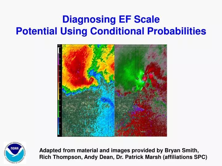
Diagnosing EF Scale Potential Using Conditional Probabilities. Adapted from material and images provided by Bryan Smith, Rich Thompson, Andy Dean, Dr. Patrick Marsh (affiliations SPC). Impact-Based Warnings

E N D
Diagnosing EF Scale Potential Using Conditional Probabilities Adapted from material and images provided by Bryan Smith, Rich Thompson, Andy Dean, Dr. Patrick Marsh (affiliations SPC)
Impact-Based Warnings • “Explore an evolution of the existing NWS warning system to facilitate improved public response and decision making in the most life-threatening weather events.” • Intended Outcomes: • reframe the warning problem and warning message in terms of societal needs • In NWS CR in last 5 years… over 3,000 tornadoes have occurred. • 87% of those tornadoes were EF0-1 resulting in 3% of tornado fatalities (all from EF1). • 13% of those tornadoes were EF2-5 resulting in 97% of all tornado fatalities • increase fidelity of warnings (distinguishing situational urgency by better emphasizing potentially HIGH IMPACT events) • incrementally improve warning system (can be done within existing structure) • conduct an initial “proof of concept” (small steps)
Overview of Smith, et. al. study (2012, 2014) Manual radar analysis Convective mode assigned using full volumetric WSR-88D archived level II data at beginning of each tornado event Low-level rotational velocity at 0.5° tilt analyzed during life span of tornado (starting one volume scan prior) and peak value recorded Near-storm environment Estimated using archived SPC mesoanalysis data Development of conditional tornado probabilities Box/Whisker diagrams developed that normalize dataset, distinguish between convective modes, and distinguish between radar range from the target Initial development of raw probabilities are range and mode independent Raw probabilities alone are not enough for decision-makers Normalized probabilities are derived as best fits for operational application Forecaster expertise continues to play a key role in conceptual application
Key Definitions Low-Level Rotational Velocity (Vrot)– taken at the 0.5 degree slice independent of radar range. For example, dataset encompasses 1-101 miles from the radar, or 100 – 10,000 feet Above Radar Level (ARL). Peak values recorded not necessarily gate-to-gate. Convective Mode - determined subjectively via examination of radar signatures Raw Conditional Probability of Tornado Intensity – probability derived from complete, unfiltered, dataset of Maximum Vrot vs. Tornado Intensity Normalized Conditional Probability of Tornado Intensity – probability derived from dataset after filtering outliers and normalizing data distribution across EF scale.
January 2009 – May 2013 Tornado segment data filtered by max EF-scale on hourly 40 km horizontal grid Tornado events < 10,000 ft above radar level (1–101 mi range) Total number of tornadoes sampled = 4378
EF-scale Data includes all convective modes and 0.5 degree samples at all ranges to 101 miles Note that the raw dataset is dominated by population of EF0-1 tornadoes (almost 5X more than EF2-5)
Shaded zones indicate most probable EF scale outcome - conditional on tornado occurrence Probabilities are based on raw, unfiltered data for the entire sample EF4+ EF0 EF3 EF1 EF2 * Probabilities are derived by accounting for each tornado (and assigned EF scale intensity) in a 10 ktVrot bin (e.g. 50-60 kts). The derived probability for each bin is assigned to the mid point of the bin (e.g. 55kts). The total sample size is 4378 tornadoes.
Same dataset, only within IBW Framework (Base Tier Warnings EF0-1 vs. Enhanced Tier Warnings EF2-5). Threshold where EF2-5 tornado becomes the most probable outcome is Vrot > 60 kts. EF2-5 EF0-1 EF2-3 EF4-5 This is very useful information. However, operationally, the use of rawprobability does not tell the whole story.
EF-scale This is because the distribution across EF scale is non-normal and is weighted toward the EF0-1 population
Standard Box and Whisker plots. Whisker tips represent 10th and 90th percentiles, while boxes are bounded by 1st and 3rd quartiles, and dash in the middle is the median value or 2nd quartile. Note that ~80% of the EF2 population, and ~40% of the EF3 population, fall below the raw conditional 60 kt threshold for EF2+ tornadoes. We need to capture more of these events. Instead, we can normalize the dataset by equally weighting each EF-scale bin (as in the diagrams above) and filter the sample “outliers” outside the tips of the whiskers.
Using the normalized and filtered data set, we can derive a set of “Normalized” probabilities for conditional tornado intensity. The “normalized” threshold where a EF2-5 tornado is the most probable outcome is 45 kts(conditional on tornado occurrence). EF0-1 EF2-5 EF4+ EF2-3
Standard Box and Whisker plots. Whisker tips represent 10th and 90th percentiles, while boxes are bounded by 1st and 3rd quartiles, and dash in the middle is the median value or 2nd quartile. For the Filtered Population… 45 kt threshold captures 100% of EF3+ tornadoes and ~75% of the EF2 population. However, it also captures ~7% of the EF0 population and ~23% of the EF1 population.
EF-scale Now applied to the non-filtered data set: The 45 kt threshold captures over 92% of EF3+ tornadoes and nearly 67% of the EF2 population. And also captures ~10% of the EF0 population and ~33% of EF1 tornadoes. In both the scatter plots and box/whisker diagrams there is significant overlap of EF1 and EF2 tornadoes between our normalized 45 kt and raw 60 kt decision thresholds. Because of this, a clean threshold is unattainable. This is where forecaster expertise becomes most important in the warning decision process.
Operational Application Diagnosing/Anticipating the Range of Possibilities • Use your situational awareness of the mesoscale and near-storm environments. • Use your understanding of convective modes. • Use your understanding of the character of the low level circulation. • Use your understanding of raw and normalized probabilities of conditional tornado intensity. 3 1 2 4 Diagnose and Anticipate Most Probable Category of Tornado Intensity (EF0-1 vs EF2-5)
Operational Forecasting Application Diagnosing/Anticipating the Range of Possibilities • Use your situational awareness of the mesoscale and near-storm environments. • Examine CAPE/Shear relationships for environments favorable for supercell development. • Examine SPC mesoscale analysis for environments favorable for larger tornadoes (e.g. Sig TOR Parameter – STP). • Be aware of low level boundaries conducive for rapid tilting and/or stretching of local vorticity maxima…. and LCL heights for estimates of cloud base. STP vs. EF-scale Neighborhood max value (dark bounded B/W plot) vs. grid value (gray shaded B/W plot) Neighborhood value STP = within 185 km radius, Grid value STP= within 40km x 40 km grid space
Operational Application Diagnosing/Anticipating the Range of Possibilities • Use your understanding of convective mode • RM Supercells are most likely to produce tornadoes that require enhanced tags. • QLCS storms that produce significant tornadoes appear to do so with lower Vrot thresholds than RM Supercells. (possibly due to enhanced forward motion vector contributions on right flanks of low level circulations). • Circulations in disorganized convection are unlikely to produce significant tornadoes that need enhanced tornado tags.
Operational Application Diagnosing/Anticipating the Range of Possibilities 3) Use your understanding of the character of the low level circulation. • Anticipate how convergent low level circulations will behave given the near-storm environment. • Be cognizant of radar range from the target. For close-in storms be sure to sample as close to the cloud base as possible for storms that are not yet tornadic. Use the 0.9 slice if necessary. • Study uses both broad Vrot maxima and Gate-to-Gate Vrot maxima, depending on which is strongest for a given case. Gate-to-Gate Vrot maxima should operationally command more weight and a lower Vrot threshold for EF2+ events. 1933Z 4.0 slice 1933Z 0.5 slice Example of a 0.5 degree convergent rotation below a broad 4.0 degree rotating mesocyclone. Prominent BWER evident in the lower right. This storm is intensifying and will soon produce a tight GTG low level circulation and eventually an EF4 tornado.
Operational Application Diagnosing/Anticipating the Range of Possibilities 4) Use your understanding of raw and normalized probabilities of conditional tornado intensity. • Keep in mind these are conditional probabilities, but also remember that lead time is important and use as many tools as possible to help anticipate tornado occurrence and potential intensity. You do not have to wait for a report of a tornado before issuing a “CONSIDERABLE DAMAGE THREAT” tag. • Once a decision is made that a tornado is likely, use the Vrot threshold of 45 knots as the initial point where you should start seriously thinking about a “CONSIDERABLE DAMAGE THREAT” tag. • Use the Vrot threshold of 60 knots as the point where you should definitely issue a “CONSIDERABLE DAMAGE THREAT” tag. d) For warning decisions between these conditional thresholds, forecaster judgment should be exercise based on your knowledge of 1) near-storm environment, 2) convective mode, 3) character and evolution of the low level circulation.
Re-Capping: Operational Application Diagnosing/Anticipating the Range of Possibilities • Use your situational awareness of the mesoscale and near-storm environments. • Use your understanding of convective modes. • Use your understanding of the character of the low level circulation. • Use your understanding of raw and normalized probabilities of conditional tornado intensity. 3 1 2 4 Diagnose and Anticipate Most Probable Category of Tornado Intensity (EF0-1 vs EF2-5)
Recently published work Wea. Forecasting (2012) Demonstrated a relationship between environment, convective mode, mesocyclone strength, and tornado damage intensity EJSSM (2013) Displayed spatial distributions of supercell-related parameters Wea. Forecasting (2013) Tornado warning performance (POD and lead-time) related to convective mode and supercell-related parameters
The following slides show some snapshots of recent significant tornadoes. • (slides courtesy of Rich Thompson, SPC).
Vrot = 84.5 kt Max grid STP = 13.1 Outlook = SLGT 5% Watch = TOR EF3 damage (17JUL2011)
Vrot = 40.8 Max grid STP = 1.9 Outlook = SLGT 5% Watch = SVR EF2 damage (20JUN2010)
Vrot = 46.7 Max grid STP = 3.6 Outlook = SLGT 10% Watch = TOR EF2 damage (5JUN2009)
Vrot = 81.6 Max grid STP = 4.6 Outlook = MDT 10% SIG Watch = TOR EF4 damage (19MAY2013)
Vrot = 69.0 Max grid STP = 5.0 Outlook = SLGT 10% Watch = TOR EF2 damage (22MAR2011)
Vrot = 51.5 Max grid STP = 1.2 Outlook = SLGT < 2% Watch = SVR EF3 damage (15MAR2012)
Vrot = 73.3 Max grid STP = 6.6 Outlook = MDT 5% Watch = SVR EF4 damage (26JUN2010)
Vrot = 76.8 Max grid STP = 0.4 Outlook = SLGT 5% Watch = TOR EF3 damage (27JUL2010)
Vrot = 69.5 Max grid STP = 7.8 Outlook = MDT 15% SIG Watch = PDS TOR EF3 damage (10APR2011)
Vrot = 88.9 Max grid STP = 10.9 Outlook = HIGH 30% SIG Watch = PDS TOR EF3 damage (15APR2012)
Vrot = 108.5 Max grid STP = 6.1 Outlook = HIGH 30% SIG Watch = PDS TOR EF3 damage (2MAR2012)
Vrot = 54.4 Max grid STP = 5.8 Outlook = SLGT 5% Watch = TOR EF3 damage (12AUG2011)
Vrot = 81.6 Max grid STP = 5.5 Outlook = HIGH 30% SIG Watch = PDS TOR EF4 damage (2MAR2012)
Vrot = 84.8 Max grid STP = 8.8 Outlook = MDT 10% SIG Watch = TOR EF4 damage (17JUN2010)
Vrot = 70.7 Max grid STP = 7.0 Outlook = MDT 15% SIG Watch = PDS TOR EF2 damage (11APR2011)
Vrot = 47.6 Max grid STP = 4.5 Outlook = SLGT 10% SIG Watch = TOR EF4 damage (17JUN2010)
Vrot = 62.7 Max grid STP = 14.2 Outlook = MDT 10% Watch = TOR EF3 damage (10APR2011)
Vrot = 69.5 Max grid STP = 3.9 Outlook = SLGT 5% Watch = TOR EF4 damage (29FEB2012)
Vrot = 65.6 Max grid STP = 3.6 Outlook = SLGT 2% Watch = SVR EF2 damage (27APR2012)
Vrot = 99.0 Max grid STP = 7.8 Outlook = MDT 10% SIG Watch = TOR EF5 damage (22MAY2011)
Vrot = 84.0 Max grid STP = 9.6 Outlook = SLGT 5% Watch = TOR EF3 damage (28MAY2013)
Vrot = 94.7 Max grid STP = 0.8 Outlook = SLGT 2% Watch = SVR EF2 damage (23JUN2012)
Vrot = 93.8 Max grid STP = 6.0 Outlook = MDT 10% SIG Watch = TOR EF3 damage (28MAY2013)
Vrot = 73.9 Max grid STP = 6.0 Outlook = MDT 10% SIG Watch = PDS TOR EF3 damage (20JUN2011)