Download
1 / 33
330 likes | 497 Views
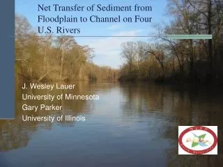
Streams/Rivers A stream is any body of water that flows under the force of gravity in a relatively narrow channel. Streams affect more of the Earth’s surface than any other agent of erosion. Streams merge together to form larger streams or rivers .

E N D
Streams/Rivers • A stream is any body of water that flows under the force of gravity in a relatively narrow channel. • Streams affect more of the Earth’s surface than any other agent of erosion. • Streams merge together to form larger streams or rivers. • Over 2 million streams in the continental U.S. • The single most important agent of land erosion: cut down into soil and bedrock • Increase their length by headward erosion • Increase their width by lateral erosion • Transport and deposit sediments
The drainage basin of the Mississippi River, covers about 3 million square km (1.2 million square miles) and consists of many smaller drainage basins. The drainage basin of the Yellowstone River is one of many that contribute to the Missouri River which is one of many that make up the drainage basin of the Mississippi.
What are the largest rivers (based on their drainage basin)? • Amazon River –2,231,000 sq. mi. • Congo River –1,550,000 sq. mi. • Mississippi River – 1,150,000 sq. mi. • Yenisei River –1,000,000 sq. mi. • Parana River – 890,000 sq. mi. • Yangtze River –750,000 sq. mi. • Orinoco River –340,000 sq. mi. • Ganges River –409,000 sq. mi. • Brahmaputra River –361,000 sq. mi.
Mississippi's watershed drains all or parts of 31 US states and 2 Canadian provinces between the Rocky and Appalachian Mountains Tributaries of the Lower Mississippi River • Ohio River is the primary branch • White River flowing in at the White River National Wildlife Refuge in east central Arkansas • Arkansas River • Big Black River in Mississippi • Yazoo River meeting the Mississippi at Vicksburg • Red River in Louisiana • The widest point exceeds 1 mile which occurs in several places.
Streams Transport and Deposit Sediment Channel material influences erosion If a channel is sandy, the particles are easily dislodged from the bed and banks. Sand particles are lifted into the water. Undercutting and dumping will cause lots of material to be carried downstream. Banks consisting of coarse gravel and cohesive clay and silt are more resistant to erosion. Channels with silty banks tend to be narrower compared to ones with sandy banks. Dependent on: 1. Discharge 2. Gradient 3. Load
Discharge - volume (amount) of water flowing past a certain point over a given unit of time A. Dictated by the size of a stream’s drainage basin • Discharge of the Mississippi River is roughly 18,000 cubic meters per second. • Amazon discharge is about 200,000 cubic meters per second B. Influenced by climatic conditions • Timing of precipitation • Quantity of snowmelt • Local soil’s ability to absorb water
Stream loads – divided into three components • Suspended load – material is carried in suspension - cloudy water, turbulent flow • Mainly fine sand, silt and clay 2. Bed load – material transported along the channel bottom, principally sand and gravel • Grains may slide, roll or bump along the bottom = traction • Grains may bounce along the bottom and take suspended leaps – saltation 3. Dissolved load – material is carried and transported in solution as ions - Detect by taste
Gradient • The slope of a stream channel • Gradient = vertical difference in elevation / horizontal distance. • The lower Mississippi River has a very low gradient, about 10 cm or less per kilometer. • Some mountain streams have a gradient more than 40 m/km • When the gradient is steeper more gravitation energy is available to drive channel flow (see handout).
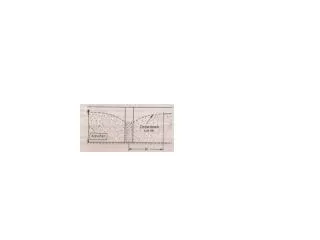
Calculate the average gradient along the stream from the red dot at A to the red dot at B. Answer: DIFFERENCE IN ELEVATION: Point A is on the 580' contour; point B is on the 520' contour. The difference in elevation is 60 feet. DISTANCE ALONG THE STREAM - each inch on the map = 2400 inches on the ground, or 200 feet. If it is 4.75 inches from A to B then 4.75 x 200 feet = 950 feet Gradient is 60 ft/ 950 ft.
Often the gradient is expressed in 'vertical feet' per 'horizontal mile'. • To do this, convert the 950 horizontal feet into miles. • There are 5,280 feet in a mile, so 950 feet = 950/5,280 miles = 0.180 miles. The gradient now is 60 vertical feet/0.180 horizontal miles. • X/60 = 1 /0.180 or X = (60*1)/0.180 • Thus, X = 333 and the gradient is 333 feet/mile
Lower part of the Mississippi River is characterized as a low gradient/ low relief (0.1 m/km) • Gentle overall slope • Erosion, transport, and deposition of fine-grained sediment • Features include meanders, floodplains, and low river terraces The oldest preserved river sediments indicate that the lower Mississippi began draining the continent during Mesozoic time. Adjustments to the river date back during the last Ice Age (2 million to 12,000 years ago).
The Upper Mississippi River is young • It formed since the retreat of the last ice sheets 10,000 years ago. • Ice sheets and glaciers covered the northern half of North America so northern rivers like the upper Mississippi did not exist.
The weight of the ice sheets depressed the crust; causing large regions to slope northward (opposite of today). • Melting of the ice released huge discharges of water and sediment that carved completely new river channels, including the upper part of the Mississippi. • Today the Mississippi River begins in a lake in Minnesota and winds its way southward, across the center of the continent. Its length is not constant because of its shifting meanders but it is 2,300 mi. (3,700 km) long. • At the mouth of the Mississippi River is a large delta southeast of New Orleans, LA.
Capacity – the maximum load of solid particles that a stream can transport • Depends on velocity of water and on the discharge • Competence – a measure of the maximum size of solid particles that a stream can transport.
Deposition of Sediment by Streams • Deposition occurs whenever a stream slows causing a reduction in competence. The flow velocity has decreased so sediments begin to settle. • Largest particles settle first • Process called sorting – particles of similar size are deposited together. • Alluvium – general term for sediment deposited by streams. Many different depositional features are composed of alluvium: levees, point bars, deltas, etc.
Stream Channel • Stream flow can be thought of as an open conduit consisting of the streambed and banks that act to confine flow except during floods. • Two basic types of channels: 1. Bedrock channels – form in headwaters • Steep slopes, waterfalls, rapids, energetic flow, potholes 2. Alluvial channels – form in sediment that was previously deposited in the valley • Material deposited by the stream can form floodplains • Shape of the channel is based on the channel’s gradient, discharge, and sediment being transported.
Meandering stream channels – follow a winding course of looping bends and turns • has one main channel cutbank – outer bank of a meander, often collapses and slumps into a stream
point bar – flow along the inside of the meander is slower • Sand deposits form • Minimum velocity • Most visible deposit within the stream channel for many a hiker
Floodplain – flat land immediately surrounding a stream channel • would be submerged if the stream were to overflow its banks Oxbow lakes/ cutoff lake/horseshoe lake- crescent /arcuate shaped water bodies • Beings as a curve or meander • A lake forms when the river finds a different and shorter course. • Form in low-lying plains. • Erosion and deposition cause a new channel to be cut through the piece of land. • These are still water lakes because water does not flow into them. • They lack an outlet and can become swamps or bogs
Mississippi River Oxbow lakes • Lake Chicot – largest oxbow lake in North America near Lake Village, Arkansas • Lake Bolivar, North of Greenville • Lake Washington, south of Greenville • Eagle Lake, Warren County, northwest of Vicksburg • De Soto Lake, Coahoma County (west of Clarksdale) • Beulah Lake – south of Great River Road State Park, north of Greenville. • Lake Whittington – north of Greenville
The floodplain of the Mississippi River has countless crescent-shaped scars of ancient meanders that have been abandoned . • Many scars have dried up as their water evaporates • During floods, a stream may cut through meander loops • Subsequent flood deposits may fill oxbow lakes -form meander scars • Rich wildlife habitats
Levee • Form along the edges of many channels and is a raised embankment; a depositional feature • Natural levees are created by the river and act as a barrier to water flow from the channel to the floodplain. • During flooding, sediment-carrying floodwater rises about the channel and begins to spreads out. As it does, the current slows and so deposits sediment in long mounds next to and paralleling the channel. • When the flood recedes, sediment that piled up next to the channel remains as an elevated rise or levee. • Coarser material is deposited closest to the river channel and finer material is deposited further away from the river channel.
Humans construct artificial levees to try to keep floodwaters from spilling onto the floodplain. This strategy commonly works for awhile. • Without artificial levees much of the local towns and cities near the river would be flooded to often • Hinder agriculture and settlements • Nearly impossible to engineer an affordable levee system that can handle the largest flood events (Hurricane Katrina in 2005) • Failure of a single levee can put lives in jeopardy, cause hundreds of millions of dollars in damages, and cause towns and neighborhoods to be abandoned as unsafe.
Mississippi Delta • A delta forms when a stream enters an ocean or a lake. • Depositional landform • Grow outward from the shoreline which causes the stream gradient to decrease. • Distributaries form (a branch of a river that flows away from the main channel)– numerous shifts in the main flow
Triangular form occurs resembling the Greek letter delta • Not all rivers have deltas. For example, powerful ocean waves associated with the Columbia River in the Pacific Northwest redistributes the material soon after it is deposited. • Rivers may not carry sufficient quantities of sediment to build a delta.
The delta of the Mississippi River resulted from the accumulation of huge quantities of sediment derived from the vast region drained by the river and its tributaries. • It extends over thousands of square kilometers and began about 6,000 years ago. • New Orleans rests where there was ocean 5,000 years ago. • The delta consists of a series of seven coalescing sub-deltas. Each delta was formed when the river left its existing channel to find a shorter, more direct path to the Gulf of Mexico.
Each subdelta interfingers and partially covers one another to produce a complex structure. • - After each portion was abandoned, coastal erosion modified the features. • - The present subdelta has been built by the Mississippi in the last 500 years, and is called a bird-foot delta.
At present, the active bird-foot delta has extended about as far as natural forces will allow. • The river is trying to cut through a narrow neck of land and shift its course to that of the Atchafalaya River. It this occurs, then the Mississippi would abandon its lowermost 500-km path in favor of the Atchafalaya ’s much shorter 225-km route. • To prevent this from occurring, a damlike structure was erected at the site where the channel was trying to break through. A flood in 1973 weakened the control structure; another massive auxiliary dam was completed in the mid-1980’s.
http://www.k5geosource.org/2activities/1invest/rocks/pg5.htmlhttp://www.k5geosource.org/2activities/1invest/rocks/pg5.html