Download
1 / 24
240 likes | 400 Views
Census from Heaven: Estimation of Human Population parameters using nighttime satellite imagery. Paul Sutton psutton@du.edu Department of Geography University of Denver May, 2000. Outline. ‘Known’ Population Data how good/bad is it? Data: brief description of DMSP OLS imagery

E N D
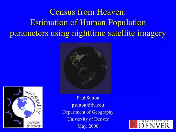
Census from Heaven:Estimation of Human Populationparameters using nighttime satellite imagery Paul Sutton psutton@du.edu Department of Geography University of Denver May, 2000
Outline • ‘Known’ Population Data how good/bad is it? • Data: brief description of DMSP OLS imagery • Estimating the Population of cities/urban clusters • Estimating intra-urban population density • ‘Temporally-Averaged’ Population Density • Questions of spatial and temporal scale • Summary/Conclusions
Absolute population of Cities Mexico City U.S. Census Bureau 28 million United Nations 16 million Sao Paulo - U.S Census Bureau 25 million - United Nations 16 million Shanghai - U.S. Census Bureau 8 million - United Nations 15 million Istanbul - Nat. Geog. Atlas* (1999) 2,938,000 [3,258,000] - Nat. Geog. Atlas* (1995) 6,620,200 [7,309,200] * Cited PRB and U.S. Census Bureau Percent of Population Urban Models described here produce national population estimates very sensitive to these numbers. Errors inflate with increasing rural fraction of population Spatial Accuracy The 1994 Guatemala census included hundreds of populated places never previously enumerated. Nevertheless, the spatial characteristics of these data were rudimentary. The “maps” supplied to enumerators in some frontier districts were generally hand drawn and based on anecdotal information. As a consequence, we have better information than ever before regarding the size and character of the Guatemalan population, we still lack a clear sense of where these people are. How Good are the numbers and who cares?When did the world population reach 6 billion?
Nighttime Satellite Imagery(DMSP OLS) ‘Percent Observation’This hyper-temporal imagery used to measure urban areal extent
Aggregate Estimation of Total City Populations Method I: Conterminous U.S. Imagery: DMSP OLS “Percent Observation” ‘Truth’: Wall to wall grid of Pop. Den. From 1990 Census Block Groups Method: Cluster adjacent pixels & Count them to measure Areal Extent of Cluster, overlay to obtain corresponding Population Method II: All Nations of the World Imagery: DMSP OLS “Percent Observation” ‘Truth’: Point Dataset of over 3000 cities with known population Method: Threshold, Cluster, & Count pixels for Area, Geo-reference & Overlay to obtain nationally specific slope & intercept parameters for the Ln(Area) vs. Ln(Popualtion) relationship from known cities, apply to all clusters
Method 1: Proof of Concept with U.S. Data(Note: This also worked well with Mexico Data)
Method II: Going GlobalUse 1,383 Known Urban Populations to Estimate Populations of the 22,920 urban clusters found in DMSP OLS imagery • Thresholding: Trade-off between too much conurbation and ability to see small settlements • Geo-Location: Provide each identified urban cluster with Country ID and related national Stats • Regression: Using Ln(Area) vs. Ln(Population) relationship to identify nationally specific slope and intercept parameters for every nation • Estimation: Estimate population of all 22,920 cluster with parameters and use % urban statistic to get total national population estimate
Thresholding:As thresholding increases intercomparisons of parameters become increasingly difficultMedium & High GDP/Capita – 80 Low GDP/Capita - 40
Regression Scatterplot of All Cities/Urban Clusters of the World w/ Known Populations • All Cities (N= 1,404): Ln(pop) = .850* Ln(Area) + 9.107 R2 = 0.68 • High Income Cities (N=471): Ln(pop) = 1.065*Ln(Area) + 7.064 R2 = 0.77 • Medium Income Cities (N=575): Ln(pop) = 1.011*Ln(Area) + 8.174 R2 = 0.78 • Low Income Cities (N=358): Ln(pop) = 0.989*Ln(Area) + 8.889 R2 = 0.80 • Venezuelan Cities (N=15): Ln(pop) = 1.164*Ln(pop) + 6.475 R2 = 0.84
Example of estimating nationally specific regression parameters for Venezuela
Some ResultsThe Big Ugly Table that you can’t read….Estimated and actual populations, regression parameters etc.
Some more results….A smaller table you might be able to read
Disaggregate or ‘Intra-Urban’ estimates of Population Density • Allocate aggregate estimate of total city population to pixels within urban cluster • Use linearly proportional relationship between light intensity and population density • Compare to residence and employment based measures of population density
Radiance Calibrated DMSP OLS images of Denveraka ‘Low-Gain’ or Light Intensity This imagery used to model intra-urban population density
Actual, Modeled, and Smoothed Representations of Minneapolis
Temporally Averaged Population Density • Census data is typically a residence based measure of population density • People, work, shop, go to school, and entertain & transport themselves outside of the home • Is a temporally averaged measure of population density useful? • (e.g. for a given 1 km2 area with 600 people in it for 8 hrs, 300 in in the next 8 hours, and 0 people in it the last 8 hours it has a temporally averaged population density of 300 persons/km2)
Are DMSP OLS based estimates of population density a temporally averaged measure of population density?
Questions of Spatial & Temporal Scale • Is a population density dataset at a 1 km2 spatial resolution useful for • Vulnerability studies? • Land-use Land-cover change studies? • Environmental Modeling? • What kind of temporal resolution of population density representations are useful and needed? • What measures other than simple density are needed and what means are there to acquire them? • When are errors of population numbers and/or spatial location unacceptably large?
Summary/Conclusions Nighttime Satellite imagery from DMSP OLS can be used to: 1) Estimate the population of urban agglomerations around the world 2) Estimate intra-urban temporally averaged measures of population density Continuing research will shed light on improved means of delineating areal extent of cities using the radiance calibrated datasets, better explanations of the national variations in the slope and intercept parameters, and a greater understanding of the spatio-temporal nature of the population density estimates produced by these methods Future research should be informed by the potential users of these datasets as to the spatial and temporal scale required, and the numerical and spatial accuracy required There is potential for inclusion of these methods into the suite of tools used for conducting national censuses throughout the world