Download
1 / 1
10 likes | 135 Views
The Climate of the Carpathian Region – Climate Atlas of the region . CARPATCLIM project. Sandor Szalai 1 , Pavel Stastny 2 , Pav o l Nejedlik 2 , Ingeborg Auer 3 , Zita Bihari 4 , Milan Dacic 5 , Sorin Cheval 6 , Danuta Limanowka 7 , Janja Milkovic 8 , Iurii Nabyvanets 9 , Radim Tolasz 10

E N D
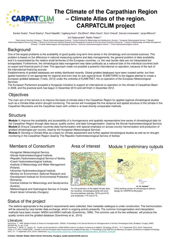
The Climate of the Carpathian Region – Climate Atlas of the region. CARPATCLIM project Sandor Szalai1, Pavel Stastny2, Pavol Nejedlik2, Ingeborg Auer3, Zita Bihari4, Milan Dacic5, Sorin Cheval6, Danuta Limanowka7, Janja Milkovic8, Iurii Nabyvanets9, Radim Tolasz10 1 Szent Istvan University (Hungary), 2 Slovak Hydrometeorological Institute, 3 Central Institute for Meteorology and Geodinamics (Austria), 4 Hungarian Meteorological Service, 5 Republic Hydrometeorological Service of Serbia, 6 Ministry for Environment National Research and Development Institute for Environmental Protection (Romania), 7 Institute of Meteorology and Water Management (Poland), 8 Croatian Meteorological and Hydrological Service, 9 Ukrainian Hydrometeorological Institute, 10 Czech Hydrometeorological Institute Background One of the largest problems is the availability of good quality long-term time series in the climatology and connected sciences. This problem is based on the difference in national measuring systems and data managements, the general problem of data availability and it is exacerbated by the relative small territories of the European countries, i.e. the near border data are not interpolated but extrapolated. Furthermore, the climatological data management was taken politically as a national task of the individual countries both on expert and financial point of view. This approach made not possible a powerful international co-operation, because of the lack of the international financing sources. Establishments of gridded databases are widely distributed recently. Global gridded databases have been created earlier, but their spatial resolution is not appropriate for regional and even less for sub-regional level. EUMETGRID is the biggest attempt to create a European gridded database (Tveito, 2010) under the umbrella of EUMETNET, the co-operation of the European Meteorological Services. The European Parliament accepted a Hungarian iniciative to support an international co-operation on the climate of Carpathian Basin in 2008, and the practical work has begun in December 2010 and will finish in December 2012. Objectives The main aim of the service is to improve the basis of climate data in the CarpathianRegion for applied regional climatological studies such as a Climate Atlas and/ordrought monitoring. The service will investigate the fine temporal and spatial structureof the climate in the Carpathian Mountains and the Carpathian basin with unified or at least directly comparable methods. Structure Module 1: Improve the availability and accessibility of a homogeneous and spatiallyrepresentative time series of climatological data for the Carpathian Regionthrough data rescue, quality control, and data homogenisation. (lead by the Slovak Hydrometeorological Service) Module 2: Ensure Carpathian countries data harmonisation with special emphasis onacross-country harmonisation and production of gridded climatologies per country. (lead by the Hungarian Meteorological Service) Module 3: Develop a Climate Atlas as a basis for climate assessment and furtherapplied climatological studies as well as for drought monitoring in the Carpathian Region (lead by The Republic Hydrometeorological Service of Serbia) Members of Consortium Area of interest Module 1 preliminary outputs • Hungarian Meteorological Service, • Slovak Hydrometeorological Institute, • Republic Hydrometeorological Service of Serbia, • Czech Hydrometeorological Institute, • Institute of Meteorology and Water Management (Poland), • Ukrainian Hydrometeorological Institute, • Ministry for Environment, National Research and • Development Institute for EnvironmentalProtection (Romania), • Central Institute for Meteorology and Geodynamics (Austria), • Meteorological and Hydrological Service of Croatia • Szent Istvan University (Hungary) For the production of the digital climate atlas, the resulting climatological grids will cover the area between latitudes 50°N and 44°N, and longitudes 17°E and 27°E, Initial working version of climatological stations design for CARPATCLIM project Status of the project The stations appropriate to the project’s requirements were collected, their metadata catalogue is under construction. The harmonization will be assured by near border data exchange, which is ongoing activity presently. The common homogenisation and interpolation methods have been chosen: MASH and MISH methods (Szentimrey, 1999). The common use of the two softwares will produce the quality control and the gridded database (Szentimrey et al., 2010) Literature: Szentimrey, T., 1999: Multiple Analysis of Series for Homogenization (MASH), Proceedings of the Second Seminar for Homogenization of Surface Climatological Data, Budapest, Hungary; WMO, WCDMP-No. 41, pp. 27-46. Szentimrey, T., Bihari, Z., Lakatos, M.: Quality control procedures in MISH-MASH systems, European Conference on Applied Climatology (ECAC), 13-17 September 2010, Zürich, Switzerland Tveito, O. E. 2010. EUMETGRID– towards a common European data infrastructure for gridded climate data. In: Proceedings of the EMS Annual Meeting & European Conference on Applied Climatology 2010, 13 – 17 September 2010, Zürich, Switzerland. http://www.emetsoc.org/annual_meetings/documents/presentations_2010/MC3_Tveito.pdf Contact: Sandor Szalai, Szent Istvan University, Hungary, szalai.sandor@mkk.szie.hu