Download
1 / 18
380 likes | 838 Views
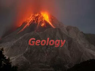
Spectral Geology. 2 June 2009. Lecture series presented by the UWA Student Chapter of the Society of Economic Geologists. Objective.

E N D
Spectral Geology 2 June 2009 Lecture series presented by the UWA Student Chapter of the Society of Economic Geologists
Objective To show how remote (airborne and satellite imagery) and field/drill-core (e.g. ASD™, microFTIR™ and Hylogger™) spectral data can be applied for exploration and research. • Asking the right questions! • Mineral system analysis • Integration with geophysical and geochemical data
Outline 9:00 - 9:15: Introduction to spectral geology and the available technologies - Carsten Laukamp (CET) 9:15 - 10:00: Is spectral geology complementary to current geophysics? - Rob Hewson (CSIRO) 10:00 - 10:20: The application of ASTER and ASD data at Pataz Goldfields, Northern Peru - Wally Witt (CET) 10:20 - 10:35: Coffee break 10:35 - 11:20: Mine scale spectral geology - Ore characterisation using "HyLogging Systems” - Erick Ramanaidou (CSIRO) 11:20 - 12:05: 3D spectral geology - mineral systems, exploration targeting and C3DMM - Tom Cudahy (CSIRO) 12:05 - 12:30: QandA - led by SEG Student Chapter and Carsten Laukamp
Mineral Mapping Theory • Diagnostic absorption features of hydroxyl mineral groups in the SWIR • Al(OH): 2170 - 2210 nm • Topaz, Pyrophyllite, Kaolinite, Montmorillonite, Muscovite, Illite • “Mg(OH)”: 2300 - 2400 nm • Chlorite, Talc, Epidote, Amphibole, Antigorite, Biotite, Phlogopite • “Fe(OH)”: 2250 - 2300 nm • Jarosite, Nontronite, Saponite, Hectorite • Si(OH): 2240 nm (broad) • Opaline silica
Composition of Minerals (Mg,Fe)oct Sitet = Aloct Al tet Muscovite Phengite • white mica composition • crystallinity of white micas or clay minerals • Mg# of chlorites • carbonate composition • … mineralminers.com/html/musmins.stm K, Na, Ca interlayer Si, Al tetrahedral Al, Fe, Mg, Cr, V octahedral From Scott and Yang, 1997
Spectral-Mineral Wavelength Regions OH-bearing hydroxyls (kaolin, chlorite, mica, amphibole) sulphates carbonates iron oxides REEs vegetation VNIR SWIR Laboratory ARGUS /AVIRIS HYMAP ASTER Landsat TM Non-OH-bearing silicates (quartz, feldspars, pyroxene, garnet) sulphates carbonates Spectral Resolution Visible Near Infrared Short Wave Infrared Thermal Infrared From Peter Hausknecht
Available Technologies(examples) • Field spectral devices: • PIMA • Fieldspec Pro • TERRASPEC • microFTIR • Hylogger system: • HyLogger™ • HyChips™ • TIR-Logger™ • Remote sensing devices: • airborne (e.g.HyMap) • satellite (e.g. ASTER)
Field Spectral Devices • Anayltical spectral devices (ASD, http://www.asdi.com) • Fieldspec Pro • 350-2500 nm • 10 nm spectral resolution @ SWIR • ~AUD$100K • TERRASPEC • More robust fibre • contact Fieldspec Pro • Integrated Spectronics (ISPL, http://www.intspec.com) • PIMA (Portable Infrared Mineral Analyser) • 1300-2500 nm • 8 nm resolution • contact • ~AUD$40K TERRASPEC
Hylogging Suite • HyLogger™ • 0.4-2.5 m • FTIR (D&P) • diamond drill core logging • ~700m / day • 1 cm line-profile footprint • HyChips™ • 0.4-2.5 m • ASD based • RAB/RC drill chip tray logging • 45 trays / hour (up to 3000 * 1 m samples p/d) • TIR-Logger™ • 2.5 -20 m • FTIR (D&P) • Diamond drill (and Chips) • ~700m / day • 1 cm line-profile footprint
Airborne HyMap Spectral Configuration – 128 channels Module Spectral range Bandwidth Average spectral across module sampling interval VIS 0.45 – 0.89 um 15 – 16 nm 15 nm NIR 0.89 – 1.35 um 15 – 16 nm 15 nm SWIR1 1.40 – 1.80 um 15 – 16 nm 13 nm SWIR2 1.95 – 2.48 um 18 – 20 nm 17 nm • Australian sensor • Sydney-based • NASA-approved • high SNR • 126 bands • 0.4-2.5 m • 3-30 m pixel • 512 pixel swath • whiskbroom • fully calibrated www.hyvista.com
Airborne HyMap white mica composition false colour • HyMap products delivered for the Qld Next Generation Mineral Mapping Project (excerpt) (http://www.em.csiro.au/NGMM/): • Natural colour basemap; • False colour basemap; • Green vegetation content; • Dry vegetation content; • Iron oxide content; • Hematite/Goethite ratio; • Ferrous iron content; • Kaolin content; • Kaolin crystallinity; • Al-smectite content; • Al-smectite composition; • White mica (paragonite-muscovite-phengite) content; • White mica composition; • White mica crystallinity; • MgOH (cc/dol/chl/ep/amph) content; • MgOH (cc/dol/chl/ep/amph) composition; • Ferric iron and MgOH; • Ferrous iron and MgOH; • Chlorite-Epidote content; • Epidote content; • Opaques; • Hydrated silica 2190 nm 5km 2215 nm Block H Al-rich Al-poor
ASTER(Advanced Spaceborne Thermal Emission and Reflective Radiometer) • “Next generation” geology-tuned satellite sensor: • 14 spectral bands including 6 SWIR and 5 TIR geological bands (+ DEM) • 15 m VNIR • 30 m SWIR • 90 m TIR • Pushbroom for VNIR and SWIR • Whiskbroom for TIR • Significant Instrument/Data Issues • atmospheric correction, SWIR X-talk, TES www.asterweb.jpl.nasa.gov www.science.aster.ersdac.or.jp
Software • TSG (the Spectral Geologist) • Field and core spectra • TSA (the Spectral Assistant) • TSG-Core Distributed through Ausspec (www.ausspec.com) • ENVI (Environment for Visualising Images) (www.ittvis.com) • Hyperspectral images • Field spectra • ERMapper (www.ermapper.com) • ASTER wizard • CSIRO/HyVista Suite • ASTER and hyperspectral multi-scene processing • C-HyperMAP • C-SatMAP • IDL based
Outline 9:00 - 9:15: Introduction to spectral geology and the available technologies - Carsten Laukamp (CET) 9:15 - 10:00: Is spectral geology complementary to current geophysics? - Rob Hewson (CSIRO) 10:00 - 10:20: The application of ASTER and ASD data at Pataz Goldfields, Northern Peru - Wally Witt (CET) 10:20 - 10:35: Coffee break 10:35 - 11:20: Mine scale spectral geology - Ore characterisation using "HyLogging Systems” - Erick Ramanaidou (CSIRO) 11:20 - 12:05: 3D spectral geology - mineral systems, exploration targeting and C3DMM - Tom Cudahy (CSIRO) 12:05 - 12:30: QandA - led by SEG Student Chapter and Carsten Laukamp