Download
1 / 11
110 likes | 116 Views
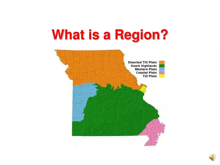
What is a Region?. Missouri’s Regions. The map shows Missouri’s regions. A region is an area with common features that set it apart from other areas. Osage Plains.

E N D
Missouri’s Regions The map shows Missouri’s regions. A region is an area with common features that set it apart from other areas.
Osage Plains Three of Missouri’s regions are plains regions. Short prairie grasses cover the Osage Plains in western Missouri. Buffalo once grazed on the Osage Plains. Today, cattle and other livestock graze here.
Osage Plains Prairies have fertile soil, which means that it is good for plants. When animals graze on prairie grasses, the plants grow back thicker and stronger than before. This process keeps the soil rich and fertile. The prairie also provides food and homes for other plants and animals.
Dissected Till Plains The Dissected Till Plains region includes the area north of the Missouri River. The land here was dissected, or taken apart, by glaciers thousands of years ago. The region is sometimes called the Glaciated Till Plains.
Dissected Till Plains St. Joseph, Hannibal, Maryville, and Kirksville are located in this region. Today, the Dissected Till Plains region has some of the best farmland in the country. Farmers grow corn, soybeans, wheat, and hay in the rich soil left behind by the glaciers.
Southeastern Lowlands The Southeastern Lowlands has moist and fertile land. The region is sometimes called the Mississippi Lowlands. A lowland is an area that is lower and flatter than surrounding areas. The Southeastern Lowlands is part of an alluvial plain, an area of sand and mud left after many floods. This region is wetter than Missouri’s other two plains regions.
Southeastern Lowlands Before the 1900’s, the Southeastern Lowlands were mostly swamps. Workers drained the area to make it suitable for farming. Now rice, corn, soybeans, and wheat grow well there. Families and farms thrive in and near cities such as New Madrid, Kennett, and Sikeston.
Ozark Plateau The Ozark Plateau is Missouri’s largest region. A plateau is a large area of flat land that is higher than surrounding areas. The Ozark Plateau extends beyond Missouri into Arkansas, Oklahoma, and Kansas. This region of Missouri is also called the Ozark Highlands.
Ozark Plateau Thick forests cover much of the Ozark Plateau. Logging is an important industry for the region. Trees provide lumber for everything from homes and furniture to boats and baseball bats. Loggers plant new trees to replace the ones they harvest.
region • An area with common features that set it apart from other areas. Back to text