Download
1 / 21
210 likes | 345 Views
Continued Improvements to the AMSR-E Rain over Land Algorithm. Ralph Ferraro, Cecilia Hernandez, Nai-Yu Wang, Kaushik Gopalan, Arief Sudradjat NOAA/NESDIS Cooperative Institute for Climate and Satellites (CICS) College Park, MD. Outline. TRMM TMI V7 GPROF/land algorithm update

E N D
Continued Improvements to the AMSR-E Rain over Land Algorithm Ralph Ferraro, Cecilia Hernandez, Nai-Yu Wang, Kaushik Gopalan, Arief Sudradjat NOAA/NESDIS Cooperative Institute for Climate and Satellites (CICS) College Park, MD AMSR-E Science Team Meeting - Asheville, NC
Outline • TRMM TMI V7 GPROF/land algorithm update • Update on Prototype, unified land surface identification • PMM Science Team Emissivity Intercomparison • Future plans for AMSR-E AMSR-E Science Team Meeting - Asheville, NC
Update on TMI 2A12 Land – V7(Wang and Gopalan) • Main focus of our effort • Improve Convective-Stratiform separation and TB85V-RR relationships to remove warm season bias • Redone several times due to lack of convergence of PR V7 • Finally settled on using “ITE233” version of PR V7 which is superior to V6 and other V7-beta versions • Results in slightly higher TMI rain than tuning that was done with PR V6 • But substantially lower than TMI V6 • We did not specifically address regional artifacts • However, V7 does use improved land/sea tag (mostly to improve ocean retrievals) AMSR-E Science Team Meeting - Asheville, NC
TMI and PR Global Land comparisonData from Jan 2008-Dec 2009
Regional Means: Amazon TMI V7 TMI ITE 233
Regional Means: Southeast US TMI V7 TMI ITE 233
Update on Prototype, Generic Land Surface Classification • Successfully tested for TRMM in off-line mode • Published in Sudradjat et al. 2011, JAMC, 50, 1200-1211 Precise FOV mapping Dynamic Snow Cover Static surface features AMSR-E Science Team Meeting - Asheville, NC
Impact on 85 GHz AMSR-E Science Team Meeting - Asheville, NC
Putting it all together…. AMSR-E Science Team Meeting - Asheville, NC
JJA (2008) vs. PR V6 Prototype Elevation Mask Fixed Arid too rigid TMI too high TMI too low Values are (2A12-2A25)/2A25 AMSR-E Science Team Meeting - Asheville, NC
Importance of Є to Improve Precipitation Over Land TB,p= Tu + [ ,p Ts + (1 - ,p) Td ] • We can obtain the other parameters from NWP or in-situ to back out Є • Critical is the degree of accuracy we can achieve • Limiting factor for onset and light precipitation rates • What happens to Є when active precip. Is falling? • Bayesian retrieval • Building databases • Constraining inversion AMSR-E Science Team Meeting - Asheville, NC
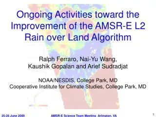
PMM Land Surface Working Group • Engage Є community • Mostly NWP focused; Impact of rain never really examined • How similar/different are Є computations from various groups? • Do they vary with target type? • Embarked on intercomparison study • Different climate zones • Focusing on C3VP, HMT, SGP • Synthesizing results… • A diverse set of targets were selected: • C3VP – 44 N, 80 W • Amazon(2) – 7 S, 70 W and 2 N, 55 W • Open Ocean(3) – 0 N, 150 W; 35 N, 30 W; 45 S, 35 W • Desert – 22 N, 29 E • SGP – 35 N, 97 W • Inland Water – 48 N, 87 W • SE US (HMT-E) - 34 N, 81 W • Wetland surface - 18 S, 57 W • Finland – 60 N, 25 E0 AMSR-E Science Team Meeting - Asheville, NC
Є Intercomparison - Participants AMSR-E Science Team Meeting - Asheville, NC
SGP Results • Best agreement at 10 GHz (1-2 %); worst at 90 GHz (5-10%) • 3% @ 37 GHz ~ 7 K for Ts=300 K • Larger than emission due to light rain…. • Best agreement when vegetation is present • LSM begins to depart from inversion techniques as ν increases AMSR-E Science Team Meeting - Asheville, NC
C3VP Results • Greater differences than at SGP • Winter season/snow • Greater differences between algorithm types • LSM higher • Demonstrates difficulties with cold season precipitation… AMSR-E Science Team Meeting - Asheville, NC
Spectral Signatures AMSR-E Science Team Meeting - Asheville, NC
Some Take Away Points • Despite best attempt for a “controlled study” there are a number of questions that remain • Sources of Ts and cloud data • Computation of Tu and Td - Number of layers, etc. • We can say that best agreement occurs • Vegetated surface state • Lower frequencies • Similar type of approaches • At least this confirms our intuition…and perhaps leads path for initial physical retrievals over land • High frequency, cold season will remain a serious challenge AMSR-E Science Team Meeting - Asheville, NC
Next Steps for AMSR-E rain over land • Work with CSU team to insure GPROF2008 is implemented properly for AMSR-E • Compare CSU surface classification scheme with ours • Bring in new data sets that focus on land retrievals • Aqua focus • MODIS and other AMSR-E products (snow, ice, vegetation, etc.) • Elevation • Other surfaces • Through PMM Science Team and this effort, begin to investigate rainfall regimes • AMSR-E channel co-variances • Use of ancillary information (Land surface temp, emissivity, etc.) • Construct databases for “self similar” surfaces and test their impact • What is the best we can do with the AMSR-E data? • What is the best we can do with ancillary + AMSR-E data? AMSR-E Science Team Meeting - Asheville, NC
Backup AMSR-E Science Team Meeting - Asheville, NC
Major Tasks for New Proposal • Continue our support to region specific issues identified over the past several years by the user community (i.e., shallow convection, high terrain precipitation, etc.). • Complete and implement a new land surface characterization routine within GPROF to improve the rain over land algorithm for AMSR-E. Included in the land surface characterization will be static (e.g., climatological, topography, etc.) and dynamic (e.g., snow cover, ice cover, soil moisture, etc.) surface information. For the latter, consideration of using other Aqua-derived information from AMSR-E and MODIS will be given priority. • Using the new surface classification scheme, develop improved rain rate retrievals that are regime dependent. Initial emphasis will be given to the TRMM domain so that collocated passive and active microwave measurements can be utilized, however, outside of this domain, other sources of rain information will be considered, including surface radars and hydrometeor profiles derived from field campaign and NWP models (coupled with radiative transfer models). • Collaborators – Kummerow, Wilheit, Njoku, Jackson, Markus AMSR-E Science Team Meeting - Asheville, NC
Regional Means: Central Africa TMI V7 TMI ITE 233