Download
1 / 2
20 likes | 140 Views
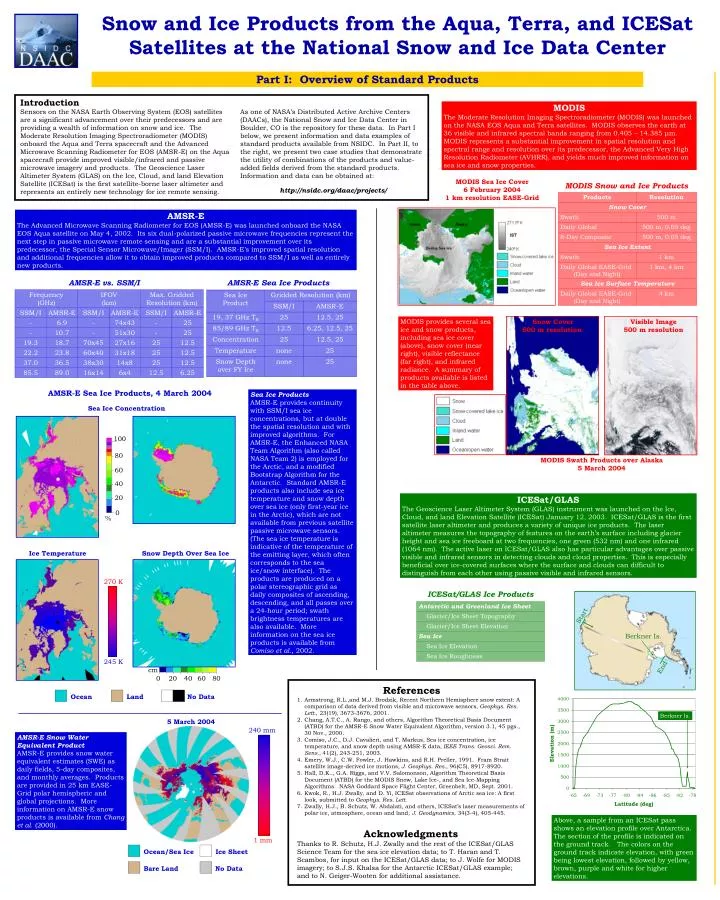
100. 80. 60. 40. 20. 0. %. Start. Berkner Is. cm. 0. 20. 40. 60. 80. End. Berkner Is. Snow and Ice Products from the Aqua, Terra, and ICESat Satellites at the National Snow and Ice Data Center. Part I: Overview of Standard Products. Introduction

E N D
100 80 60 40 20 0 % Start Berkner Is. cm 0 20 40 60 80 End Berkner Is. Snow and Ice Products from the Aqua, Terra, and ICESat Satellites at the National Snow and Ice Data Center Part I: Overview of Standard Products Introduction Sensors on the NASA Earth Observing System (EOS) satellites are a significant advancement over their predecessors and are providing a wealth of information on snow and ice. The Moderate Resolution Imaging Spectroradiometer (MODIS) onboard the Aqua and Terra spacecraft and the Advanced Microwave Scanning Radiometer for EOS (AMSR-E) on the Aqua spacecraft provide improved visible/infrared and passive microwave imagery and products. The Geoscience Laser Altimeter System (GLAS) on the Ice, Cloud, and land Elevation Satellite (ICESat) is the first satellite-borne laser altimeter and represents an entirely new technology for ice remote sensing. MODIS The Moderate Resolution Imaging Spectroradiometer (MODIS) was launched on the NASA EOS Aqua and Terra satellites. MODIS observes the earth at 36 visible and infrared spectral bands ranging from 0.405 – 14.385 μm. MODIS represents a substantial improvement in spatial resolution and spectral range and resolution over its predecessor, the Advanced Very High Resolution Radiometer (AVHRR), and yields much improved information on sea ice and snow properties. As one of NASA’s Distributed Active Archive Centers (DAACs), the National Snow and Ice Data Center in Boulder, CO is the repository for these data. In Part I below, we present information and data examples of standard products available from NSIDC. In Part II, to the right, we present two case studies that demonstrate the utility of combinations of the products and value-added fields derived from the standard products. Information and data can be obtained at: http://nsidc.org/daac/projects/ MODIS Sea Ice Cover 6 February 2004 1 km resolution EASE-Grid MODIS Snow and Ice Products AMSR-E The Advanced Microwave Scanning Radiometer for EOS (AMSR-E) was launched onboard the NASA EOS Aqua satellite on May 4, 2002. Its six dual-polarized passive microwave frequencies represent the next step in passive microwave remote sensing and are a substantial improvement over its predecessor, the Special Sensor Microwave/Imager (SSM/I). AMSR-E’s improved spatial resolution and additional frequencies allow it to obtain improved products compared to SSM/I as well as entirely new products. AMSR-E vs. SSM/I AMSR-E Sea Ice Products MODIS provides several sea ice and snow products, including sea ice cover (above), snow cover (near right), visible reflectance (far right), and infrared radiance. A summary of products available is listed in the table above. Snow Cover 500 m resolution Visible Image 500 m resolution AMSR-E Sea Ice Products, 4 March 2004 Sea Ice Products AMSR-E provides continuity with SSM/I sea ice concentrations, but at double the spatial resolution and with improved algorithms. For AMSR-E, the Enhanced NASA Team Algorithm (also called NASA Team 2) is employed for the Arctic, and a modified Bootstrap Algorithm for the Antarctic. Standard AMSR-E products also include sea ice temperature and snow depth over sea ice (only first-year ice in the Arctic), which are not available from previous satellite passive microwave sensors. (The sea ice temperature is indicative of the temperature of the emitting layer, which often corresponds to the sea ice/snow interface). The products are produced on a polar stereographic grid as daily composites of ascending, descending, and all passes over a 24-hour period; swath brightness temperatures are also available. More information on the sea ice products is available from Comiso et al., 2002. Sea Ice Concentration MODIS Swath Products over Alaska 5 March 2004 ICESat/GLAS The Geoscience Laser Altimeter System (GLAS) instrument was launched on the Ice, Cloud, and land Elevation Satellite (ICESat) January 12, 2003. ICESat/GLAS is the first satellite laser altimeter and produces a variety of unique ice products. The laser altimeter measures the topography of features on the earth’s surface including glacier height and sea ice freeboard at two frequencies, one green (532 nm) and one infrared (1064 nm). The active laser on ICESat/GLAS also has particular advantages over passive visible and infrared sensors in detecting clouds and cloud properties. This is especially beneficial over ice-covered surfaces where the surface and clouds can difficult to distinguish from each other using passive visible and infrared sensors. Ice Temperature Snow Depth Over Sea Ice 270 K ICESat/GLAS Ice Products 245 K • References • Armstrong, R.L.,and M.J. Brodzik, Recent Northern Hemisphere snow extent: A comparison of data derived from visible and microwave sensors, Geophys. Res. Lett., 23(19), 3673-3676, 2001. • Chang, A.T.C., A. Rango, and others, Algorithm Theoretical Basis Document (ATBD) for the AMSR-E Snow Water Equivalent Algorithm, version 3.1, 45 pgs., 30 Nov., 2000. • Comiso, J.C., D.J. Cavalieri, and T. Markus, Sea ice concentration, ice temperature, and snow depth using AMSR-E data, IEEE Trans. Geosci. Rem. Sens., 41(2), 243-251, 2003. • Emery, W.J., C.W. Fowler, J. Hawkins, and R.H. Preller, 1991. Fram Strait satellite image-derived ice motions, J. Geophys. Res., 96(C5), 8917-8920. • Hall, D.K.., G.A. Riggs, and V.V. Salomonson, Algorithm Theoretical Basis Document (ATBD) for the MODIS Snow, Lake Ice-, and Sea Ice-Mapping Algorithms. NASA Goddard Space Flight Center, Greenbelt, MD, Sept. 2001. • Kwok, R., H.J. Zwally, and D. Yi, ICESat observations of Arctic sea ice: A first look, submitted to Geophys. Res. Lett. • Zwally, H.J., B. Schutz, W. Abdalati, and others, ICESat’s laser measurements of polar ice, atmosphere, ocean and land, J. Geodynamics, 34(3-4), 405-445. Ocean Land No Data 5 March 2004 240 mm AMSR-E Snow Water Equivalent Product AMSR-E provides snow water equivalent estimates (SWE) as daily fields, 5-day composites, and monthly averages. Products are provided in 25 km EASE-Grid polar hemispheric and global projections. More information on AMSR-E snow products is available from Chang et al. (2000). Above, a sample from an ICESat pass shows an elevation profile over Antarctica. The section of the profile is indicated on the ground track. The colors on the ground track indicate elevation, with green being lowest elevation, followed by yellow, brown, purple and white for higher elevations. Acknowledgments Thanks to R. Schutz, H.J. Zwally and the rest of the ICESat/GLAS Science Team for the sea ice elevation data; to T. Haran and T. Scambos, for input on the ICESat/GLAS data; to J. Wolfe for MODIS imagery; to S.J.S. Khalsa for the Antarctic ICESat/GLAS example; and to N. Geiger-Wooten for additional assistance. 1 mm Ocean/Sea Ice Ice Sheet Bare Land No Data
Alaska Beaufort Sea W N 270 K E Barrow 235 K 100 80 60 40 20 0 % Lead Walter N. Meier, Melinda Marquis, Marilyn Kaminski, Richard Armstrong, Mary Jo Brodzik, Matt Savoie National Snow and Ice Data Center, University of Colorado, Boulder, CO Part II: Improved Snow and Ice Analyses from Combined Products 1. A Multisensor, Multiparameter Investigation of a Large Beaufort Sea Lead 2 – 7 March 2004 AMSR-E 89V TB (K) 6.25 km Gridded Resolution 160 240 Daily sea ice motions derived from daily 89 vertically polarized TB fields show strong divergent motion west of Barrow 2-4 March causing the large lead (A) to form, followed the next day by an even larger lead to the east (B). There is also a strong off-shore flow west of Barrow, resulting in a large coastal lead. Circulation changes on 4-5 March turn the flow to an onshore one and the lead starts closing. The motions are estimated using a maximum cross-correlation scheme that matches features in co-located image pairs (Emery et al., 1991). The motion fields below encompass a larger region than the 89V images to show the overall circulation of the surrounding region. The AMSR 89V image region below is outlined in the blue box and the lead (B) is denoted by the thick blue line. Introduction By combining multiple products from multiple sensors, more complete information on sea ice processes can be obtained. To illustrate such capabilities of the new EOS products, a case-study is presented in the Beaufort Sea during early March 2004. As seen in daily 89 GHz imagery to the right, two large leads form in the Beaufort Sea north of Barrow, Alaska. A large coastal lead also forms to the west of Barrow. The region of study is indicated in the maps to the right. No single sensor or product can retrieve all information of interest, but through the combination of products from the three sensors the lead opening and refreezing process can be more completely investigated. A Region of Study 2 March A Sea Ice Motion Derived from AMSR-E 89V Imagery 3 March B 20 cm s-1 The AMSR-E 19 and 37 GHz channels used for sea ice concentration have a larger footprint and thus cannot resolve the lead, except as a small region of reduced ice concentration (circled). It does resolve the larger coastal lead near Barrow. 2 – 3 March 3 – 4 March 4 – 5 March 4 March AMSR-E Sea Ice Concentration 12.5 km Gridded Resolution MODIS Ice Surface Temperature (Night) Under clear skies, the higher spatial resolution (500 m) of MODIS clearly detects the warmer temperatures in the lead and resolves many fracture features west (above the lead in the image) of the lead; in the zoomed region, the cooler temperatures on the leeward side of the lead indicate where freezing has begun. Clouds contaminate temperatures east of the lead. The large coastal lead is also clearly visible near Barrow. Clouds 5 March ICESat/GLAS also detects the lead, clearly visible as a thinner, smoother region. The freeboard/draft was estimated from the sea ice elevation product with corrections made for geoid discrepancies. This is a simple correction and ignores clouds and other possible error sources. However, it does appear to yield a fair representation of the ice cover, particularly the lead. By 7 March, the lead appears to be completely frozen over. Using nearby Barrow air temperatures from NOAA and Lebedev’s ice growth equation (based on freezing degree days) yields a theoretical thickness of 0.16 m for the thinnest ice in the lead, which is quite close to the estimate from ICESat/GLAS; the plot also shows thicker ice on the leeward side of the lead where ice growth has continued longer and where rafting/ridging may be occurring. 6 March AMSR-E Sea Ice Temperature 25 km Gridded Resolution The AMSR-E ice temperature algorithm does not indicate any leads at all because of its use of the low resolution 6.9 GHz channel. Thus, while this field cannot directly be used to investigate the lead, it can provide valuable information on general conditions when clouds exist and temperatures cannot be retrieved from MODIS (as was the case on 6 March). 270 K 7 March Sea Ice Freeboard and Estimated Draft Derived from the Standard Data Product GLAS/ICESat L2 Sea Ice Altimetry Data (GLA13) 245 K ICESat transect 2. AMSR-E/MODIS Blended Experimental Snow Cover Product 5 – 12 March 2004 AMSR-E Snow Water Equivalent Blended AMSR-E/MODIS Snow Cover MODIS Snow-Covered Area 100 ≥300 ≥300 267-299 267-299 234-267 234-267 200-233 167-199 200-233 % Snow-Covered Area 134-166 Introduction NSIDC is currently developing an algorithm to produce snow cover estimates using combined data from both AMSR-E and MODIS. The fields are 8-day composites, projected on the 25 km Northern Hemisphere EASE-Grid. By combining estimates from AMSR-E snow water equivalent (SWE) and MODIS snow-covered area fields more accurate and more complete fields can be obtained. 167-199 101-133 134-166 67-100 34-66 101-133 8-33 1 67-100 SWE (mm) 34-66 Vis. >25% Ice Sheet 8-33 Ocean No Tbs No Tbs SWE (mm) In the blended product, regions with greater than 25% snow-covered area detected by MODIS supplement AMSR-E SWE estimates. SWE is estimated from AMSR-E using a different algorithm from the standard product (Armstrong and Brodzik, 2001). The MODIS snow cover image is based on the percentage of snow covered area detected by MODIS over the 8-day period.