Download
1 / 35
380 likes | 582 Views
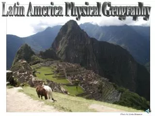
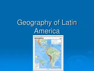
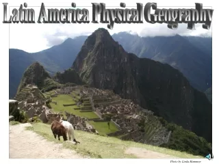
Physical Geography of Latin America. The Three Divisions. Geographers divide Latin America into three areas: Middle America : includes Mexico and the 7 countries of Central America South America : the largest land area of Latin America

E N D
The Three Divisions • Geographers divide Latin America into three areas: • Middle America: includes Mexico and the 7 countries of Central America • South America: the largest land area of Latin America • Of S. America’s 13 countries, Brazil is the largest in land area and population • Caribbean (aka-West Indies): The Bahamas, the Greater Antilles, and the Lesser Antilles
1 • Latin America is divided into three regions. Identify each region and list 3 countries in each. • Create a quick sketch of Latin America and circle each of the three regions.
Las Montañas y Las Mesetas (Mountains & Plateaus) • Profile: Towering mountains • Mountains begin in the Rocky Mountains of North America, name changes as you move south • Mexico: Sierra Madre • Central America: Central Highlands • South America: Andes • Rugged landscape because much of the area sits along the Pacific Ring of Fire, where plates among the earth’s crust have collided. • Collisions mountains, volcanoes, and earthquakes changing landscape
2 *Hint: following the Rocky Mtns. into Latin America! • Name the biggest mountain ranges in: • Mexico • Central America • South America • What types of plate boundaries formed these mountain ranges? • Using the picture on the right: • What effect does you think this has on the environment and mountains?
3- Pros & Cons of the Physical Geography- Mountains • Write these notes: • Pros • Lowland mountain areas = cooler climate • Rich natural resources: water, volcanic soil, timber, minerals • Cons • Ruggedness blocks movement & trade • Isolation*- • QUESTION: before cars and other modern transportation methods, how could mountains cause isolation? • Radio, TV, air transport work to break down physical barriers. • QUESTION: If you were the owner of a radio/tv station, why would not enjoy the physical environment of Latin America?
4- Mexican Plateau & Central Highlands • Notes: • Surrounded by the two Sierra Madre mountain ranges: Sierra Madre Occidental & Sierra Madre Oriental • What is the climate and vegetation characteristics of the Mexican Plateau? (3-4 items required) • What are the Central Highlands? How did they form?
South American Grasslands • Llanos of Colombia, Pampas of Argentina • Pampas: a major “breadbasket”, produce large amounts of wheat & corn • Provide wide grazing lands for beef cattle • Employ cowhands to drive herd across the grass/terrain • Llaneros: Llanos • Gauchos: pampas • How can they help the economy of Latin America?
5- South American Grasslands • Define & give location (country): • Llanos • Pampas • How can they help the economy of Latin America? • Define: • Llaneros • Gauchos • Draw a picture for what life is like for these 2 groups
H2O (Water) • Rio Grande: border between Mexico & the US • Amazon = world’s widest river (#2 longest) • Is navigable!! • Parana, Paraguay, and Uruguay Rivers provide hydroelectric power, or electricity generated from the energy of water • Argentina, Bolivia, Brazil, Paraguay, and Uruguay • Also provides inland water routes
6- Major Waterways • What is the border between Texas and Mexico? • Form an argument for or against open immigration between Mexico and Texas. (Give at least 3 reasons why you agree or disagree. Use at least one website source when forming your argument) • What is the largest river in Latin America? What does it mean when a river is “navigable”? • What kind of power do the Parana River, Paraguay River, and Uruguay River provide? Which countries benefit from this power?
The Andes, Backbone of South America • The world’s longest mountain range • Made up of several mountain ranges, called cordilleras • Pass through seven countries, vary in landscapes • Grouped into three sections: • Northern Andes: Venezuela and Colombia • Central Andes: Ecuador, Peru, and Bolivia • Southern Andes: Chile and Argentina
7- Explain what is happening in this image. What are some differences in each zone in this image? (think of climate and vegetation) What is the world’s Longest mountain range? How many countries does it span? Which country is furthest North? South?
8- What does Tierra Caliente mean? Tierra Templada? Tierra Fria? Tierra Helada? What elevation would you have in each zone? Describe the climate, vegetation, and what types of crops would be in each zone.
Tierra Caliente: Tropical! • Lowest elevation zone • Anywhere from Sea level to no higher than 3,000 feet • Tropical climate, year-round warm temperatures (75-80 degrees) • Eastern slopes: Broadleaf Evergreen forests • Western slopes: tropical grasslands • Heat = difficult places to live • Crops: bananas, rice, sugarcane
Tierra Templada: Land of Eternal Spring • 3,000-6,000 feet above sea level • Mild, temperate climate with temperatures between 65 & 75 degrees yearly. • Vegetation changes with elevation • Lower elevations: palms, bamboo, jungle vines • Higher elevations: broadleaf evergreen forests • More populated, Mestizos (indigenous + European) • Lower levels: grow oranges & bananas • Higher levels: corn, beans, other veggies • Main commercial crop: Coffee
Tierra Fría • Between 6,000 & 12,000 feet • Average temps: 55-65 degrees, colder at night (freezing at higher elevations) • Altiplano (11,000): Lake Titicaca • World’s highest navigable lake (12,500 feet above sea level) • Navigable large & deep enough to hold large boats • Hidden treasures! • Tree line—between 10,000 & 12,000 feet • Crops: potatoes, wheat, barley, corn, apples & pears
Adaptations in the Tierra Fria • Build houses of stone or adobe brick (thicker) • Body adaptation: larger lungs • Farmers practice terracing to create flat lands on the slopes and steep hillsides of this area. • Vertical Trade: trade of farm products between the higher & lower elevation zones • People of lower elevations bring their crops to the people of the higher elevations (low high) • Bananas, oranges, tomatoes • Higher elevations bring to lower (High low) • Potatoes, wheat
9- Describe the Significance of… • Lake Titicaca • Terrace farming • Atacama Desert (Definition and how they shape the lives of people in Latin America) Create a quick sketch of a climate zones map of Latin America
Tierra Helada: Cold & Windy • Between 12,000 & 15,000 feet above sea level • 20-55 degrees (F) • Snow line: elevation at which permanent snow & ice begin (upper Tierra Helada) • Shrubs & grasses • Crops: quinoa, potatoes • Llamas & alpacas provide wool for blankets, bags and clothing • Some people work in the mines, because there are many mineral deposits • Tin, lead, copper, silver • Glaciers above snow line melt in summer, water into streams in lower elevations
Tropical: Rain Forest • Hot temps, abundant rainfall year-round • Most Rain: January - June • Evergreens form a dense canopy, or a continuous layer of leaves • Amazon Basin: many species of plants & animals • Location: S. America (Brazil, Amazon Basin)
Tropical: Tropical Savanna • Locations: • Southwestern Mexico • Most Caribbean Islands • North-central South America • Hot temps, abundant rainfall year-round • Difference? DRY SEASON • Grasslands (Colombia & Venezuela)
Mid-Latitude: Humid Subtropics • Southeastern South America • (Rio De Janeiro, Brazil, Argentina, Uruguay) • Short & mild winters • Long, hot & humid summers with dry periods • Short grasses in the pampas
Dry: Desert & Steppe Areas • Northern Mexico, coastal Peru and Chile, southeastern coast of Argentina • Very little rainfall in the desert • Atacama Desert: Chile • So dry, some places in this desert have never recorded any rainfall!! • Cacti, shrubs—not much vegetation • Steppes: N Mexico, NE Brazil, South Central South America • Hot summers, cool winters, light rainfall