Download
1 / 50
500 likes | 625 Views
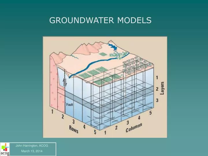
GROUNDWATER MODELS. John Harrington, ACOG March 13, 2014. GROUNDWATER MODELS. TODAY WE PUMP THE WELL,. GROUNDWATER MODELS. WRITE OUR REPORTS,. GROUNDWATER MODELS. AND MAKE SURE OUR CUSTOMERS ARE HAPPY. GROUNDWATER MODELS. WE WOULD LIKE DEMAND TO BE HIGH, BUT NOT OVERWHELM THE SYSTEM.

E N D
GROUNDWATER MODELS John Harrington, ACOG March 13, 2014
GROUNDWATER MODELS TODAY WE PUMP THE WELL,
GROUNDWATER MODELS WRITE OUR REPORTS,
GROUNDWATER MODELS AND MAKE SURE OUR CUSTOMERS ARE HAPPY
GROUNDWATER MODELS WE WOULD LIKE DEMAND TO BE HIGH, BUT NOT OVERWHELM THE SYSTEM. DEMAND CAPACITY
GROUNDWATER MODELS WE’RE GOOD AS LONG AS THE MONEY KEEPS COMING IN AND THE WATER KEEPS COMING IN.
GROUNDWATER MODELS OKAY, SO HOW MUCH WATER HAS COME INTO YOUR SYSTEM? DO YOU REALLY KNOW??
GROUNDWATER MODELS WHY MODEL? TO MAKE PREDICTIONS ABOUT THE RESPONSE TO STRESS IN A GROUNDWATER SYSTEM http://www.slideshare.net/cpkumar/introduction-to-groundwater-modelling-2490234#
GROUNDWATER MODELS THIS IS NOT UNLIKE AN ACCOUNTING SYSTEM, WHICH MEASURES ALL THE STRESSORS IN YOUR WALLET! AND WATER IS MONEY!
GROUNDWATER MODELS • STRESSORS IN A GROUNDWATER SYSTEM • Withdrawals • Wells • Stream Discharge • Transpiration • Evaporation • Recharge • Precipitation • Stream Recharge • ASR • Flow • Always goes from high head to low head
GROUNDWATER MODELS DISCHARGE WELLS http://wellwater.oregonstate.edu/groundwater/html/GroundwaterWells.htm
GROUNDWATER MODELS DISCHARGE WELLS http://wellwater.oregonstate.edu/groundwater/html/GroundwaterWells.htm
GROUNDWATER MODELS DISCHARGE STREAM DISCHARGE
GROUNDWATER MODELS DISCHARGE TRANSPIRATION
GROUNDWATER MODELS DISCHARGE EVAPORATION
GROUNDWATER MODELS RECHARGE PRECIPITATION
GROUNDWATER MODELS RECHARGE STREAM RECHARGE
GROUNDWATER MODELS RECHARGE ASR
GROUNDWATER MODELS FLOW FLOW MAY BE IN FEET PER DAY/YEAR/CENTURY/MILLENNIA
GROUNDWATER MODELS THESE ARE A LOT OF SYSTEMS TO ACCOUNT FOR, BUT: THE ERA OF “JUST PUMP IT” IS OVER! THE ERA OF MANAGING AND ACCOUNTING FOR OUR RESOURCES IS JUST BEGINNING!
THE ERA OF MANAGING AND ACCOUNTING 2010 – THE BEGINNING OF THE DROUGHT
THE ERA OF MANAGING AND ACCOUNTING 2010 – THE BEGINNING OF THE DROUGHT
THE ERA OF MANAGING AND ACCOUNTING 2012 - THE COMPREHENSIVE WATER PLAN
THE ERA OF MANAGING AND ACCOUNTING 2013 – Oklahoma Approves the Recommended Cap based on the Simpson-Arbuckle Groundwater Model
THE ERA OF MANAGING AND ACCOUNTING MANAGEMENT means making decisions to achieve goals without violating specified constraints. GOOD MANAGEMENT requires information on the response of the managed system to the proposed activities. This information enables the decision-maker to COMPARE ALTERNATIVE ACTIONS and to ensure that constraints are not violated.
GROUNDWATER MODELS WHICH BRINGS US BACK TO THE GROUNDWATER MODEL!! X NOT THIS MODEL THIS MODEL
GROUNDWATER MODELS • Although groundwater flow models can't be as detailed or as complex as the real system, models are useful in at least four ways: • Models integrate and assure consistency among aquifer properties, recharge, discharge, and groundwater levels. • Models can be used to estimate flows and aquifer characteristics for which direct measurements are not available. • Models can be used to simulate response of the aquifer under hypothetical conditions. • Models can identify sensitive areas where additional hydrologic information could improve understanding.
GROUNDWATER MODELS Groundwater models are used to predict the effects of hydrological changes on the behavior of the aquifer and are often named groundwater simulation models. Groundwater models are nowadays used in various water management plans for urban areas in many parts of the country. The mathematical or the numerical models are usually based on the real physics the groundwater flow follows. These mathematical equations are solved using numerical codes such as MODFLOW, ParFlow, HydroGeoSphere, OpenGeoSys etc.
GROUNDWATER MODELS • Data inputs needed for the model: • Hydrological inputs • Operational inputs • External Conditions: Initial and Boundary conditions • Hydraulic parameters http://en.wikipedia.org/wiki/Groundwater_model
Data inputs needed for the model • Hydrological Data Inputs • Rainfall • Surface water infiltration • ASR • Evaporation • Evapotranspiration • These inputs may vary in both time and space. Some of this data is measured by climatological services such as MESONET. • Some surface water data is measured by USGS.
Inputs needed for the model • Operational Inputs - Water Management Data: • Irrigation • Drainage • Pumping from wells • Water table information • Retention or infiltration basins • These inputs vary in quantity and quality.
Inputs needed for the model • External Conditions: Boundary Conditions • Levels of the water table • Artesian pressures • Hydraulic head along the boundaries of the model (the head conditions) • Groundwater inflows and outflows along the boundaries of the model (the flow conditions).
Inputs needed for the model External Conditions: Initial Conditions The initial conditions refer to initial values of elements that may increase or decrease in the course of the time inside the model domain and they cover largely the same phenomena as the boundary conditions do. These inputs vary in quantity and quality.
Inputs needed for the model • Hydraulic Parameters • Geometry and distances in the domain to be modelled (Geology, size of model) • Topography • Horizontal/vertical hydraulic conductivity of rock layers • Aquifer transmissivity and resistance • Aquifer porosity and storage coefficient • Capillarity of the unsaturated zone
Other Considerations Dimensions Groundwater models can be one dimensional, two dimensional, and three dimensional. One-dimensional models can be used for the vertical flow in a system of parallel horizontal layers.
Other Considerations Dimensions Two-dimensional models apply to a vertical plane while it is assumed that the groundwater conditions repeat themselves in other parallel vertical planes. Spacing equations of subsurface drains and the groundwater energy balance applied to drainage equations are examples of two-dimensional groundwater models.
Other Considerations Dimensions Three-dimensional models like MODFLOW require discretization of the entire flow domain. To that end the flow region must be subdivided into smaller elements (or cells), in both horizontal and vertical sense. Within each cell the parameters are maintained constant, but they may vary between the cells.
GROUNDWATER MODELS SOME THOUGHTS All this input requires a lot of data. Data can be very manpower-intensive (READ EXPENSIVE!) Do we spend the time and money now to get better management of our water resources OR Do we wait until we are required to do so?
GROUNDWATER MODELS • “Essentially, all models are wrong, but some are useful“ • George Edward Pelham Box • (1919-2013)
GROUNDWATER MODELS WHY MODEL? TO MAKE PREDICTIONS ABOUT THE RESPONSE TO STRESS IN A GROUNDWATER SYSTEM BECAUSE I THINK I HAVE A PROBLEM….. x
I THINK I HAVE A PROBLEM PROBLEM: We have just approved a new development with 200 homes that have wells and septic. Everyone is now yelling that we are draining the aquifer. Are we?
I THINK I HAVE A PROBLEM ANSWER: The highest drawdown will be confined mostly to the development itself, drawing the SWL down about 10 feet.
I THINK I HAVE A PROBLEM PROBLEM: We have a nice well field, but what about those septic tanks across the river?
I THINK I HAVE A PROBLEM We want to plan the drilling location spacing on our well field. (and not drain somebody else’s water)
I THINK I HAVE A PROBLEM Conclusions (Abstract from Scientific Investigations Report 2013–5219) “For scenario 1, the pumping rate at all cells that reduced the saturated thickness in one-half of the cells to or below 15 feet (4.57 meters) after 50 years was between 1.1 and 1.5 (acre-feet/acre)/year. The results of scenario 2 indicate the aquifer would be 50 percent depleted after between 35 and 41 years of pumping 2 (acre-feet/acre)/year using 10 percent increase and decrease in specific yield. This analysis indicates that this pumping rate of 2 (acre-feet/acre)/year is not sustainable for more than 41 years if every landowner with a potential well in each acre in the Central Oklahoma aquifer exercised their temporary right to pump at that rate.”
I THINK I HAVE A PROBLEM There is now a really nice MODFLOW Model on the central Oklahoma aquifer. Can we use it for something else besides the yield study?
I THINK I HAVE A PROBLEM Parent-Daughter Models
IN CONCLUSION….. • As water supplies become more scarce: • Water management will become more important. • Data collection will become more important. • Groundwater modeling will become more important. • Groundwater modeling is a system that can account for water quantity, quality, and flow much the same as an accounting system can account for wealth accumulation and flow. • After all, water is money!