Download
1 / 60
610 likes | 779 Views
RICH,. AN ECMWF LECTURER. Numerical Weather Prediction Parametrization of sub-grid physical processes Clouds (4) Cloud Scheme Validation. Richard Forbes (with thanks to Adrian Tompkins and Christian Jakob ) forbes@ecmwf.int. Cloud observations. Parametrization improvements.

E N D
RICH, AN ECMWF LECTURER Numerical Weather Prediction Parametrization of sub-grid physical processesClouds (4)Cloud Scheme Validation Richard Forbes (with thanks to Adrian Tompkins and Christian Jakob) forbes@ecmwf.int
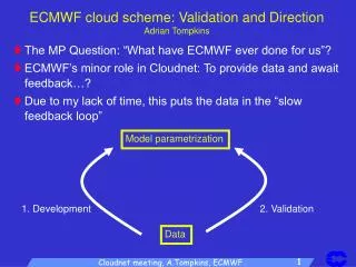
Cloud observations Parametrizationimprovements Error Cloud simulation Cloud Validation: The issues • AIM: To perfectly simulate one aspect of nature: CLOUDS • APPROACH: Validate the model generated clouds against observations, and use the information concerning apparent errors to improve the model physics, and subsequently the cloud simulation. Sounds easy?
Cloud Validation: The problems • How much of the ‘error’ derives from observations? Cloud observations error = e1 Parametrizationimprovements Error Cloud simulation error = e2
turbulence radiation cloud physics dynamics convection Cloud Validation: The problems • Which Physics is responsible for the error? Cloud observations Parametrizationimprovements Error Cloud simulation
The path to improved cloud parametrization… Parametrizationimprovement ? Composite studies NWP validation Case studies Cloud validation Climatological comparison
1. Methodology for diagnosing errors and improving parametrizations
Cloud Validation: The problems 1. Methodology Cloud observations Parametrizationimprovements Error Cloud simulation turbulence radiation cloud physics dynamics convection 7
A strategy for cloud parametrization evaluation • For example, systematic errors in radiation, cloud cover, precipitation… • Use long timeseries of observational data • Satellite • Ground-based profile • NWP verification From C.Jakob 8
Model climate: Broadband radiative fluxes Can compare Top of Atmosphere (TOA) radiative fluxes with satellite observations: e.g. Example of TOA Shortwave radiation (TSR) from an old version of the model (operational in 1998) JJA 87 TSR Model (Version CY18R6) minus Observations (ERBE) Stratocumulus regions bad - also North Africa (old cycle!)
Model climate:Cloud radiative “forcing” • Problem: Can we associate these “errors” with clouds? • Another approach is to examine “cloud radiative forcing” JJA 87 SWCRF Model (Version CY18R6) minus Observations (ERBE) Cloud Problems: strato-cu YES, North Africa NO!
Model climate“Cloud fraction” or “Total cloud cover” Can also compare other variables to derived products: CC JJA 87 TCC Model (Version CY18R6) minus Observations (ISCCP) References: ISCCP - Rossow and Schiffer, Bull Am Met Soc. 91, ERBE - Ramanathan et al. Science 89
Model climate Top-of-atmos net LW radiation1-year average -150 Model T159 L91 -300 A more recent version of the IFS model… -150 CERES satellite obs -300 too high Difference too low
Model climate Top-of-atmos net SW radiation1-year average 350 Model T159 L91 100 350 CERES satellite obs 100 albedo high Difference albedo low
Model climate 80 Model T159 L91 10 80 Total Cloud Cover (TCC)1-year average ISCCP satellite obs 10 TCC high Difference TCC low
Model climate 250 Model T159 L91 25 250 SSMI satellite obs Total Column Liquid Water (TCLW)1-year average 25 high Difference low
Statistical evaluation:Long term ground-based observations European observation sites • Network of stations providing profile data for multi-year period • “CloudNet” project (www.cloud-net.org) European multi-site data processing using identical algorithms for model evaluation. • “FASTER” project (faster.arm.gov) processing for global observation sites from the ARM programme (currently active).
“Permanent” ARM sites and movable “ARM mobile facilities” for observational campaigns (www.arm.gov) Statistical evaluation:Long term ground-based observations Global ARM observation sites 17
Cloud fraction Chilbolton Observations Met Office Mesoscale Model ECMWF Global Model Meteo-France ARPEGE Model KNMI RACMO Model Swedish RCA model
Statistical evaluation:CloudNet Example • In addition to standard quicklooks, longer-term statistics are available. • This example is for ECMWF cloud cover during June 2005. • Includes pre-processing to account for radar attenuation and snow. • See www.cloud-net.org for more details and examples!
Statistical evaluation:Short-range NWP versus long-range “climate” • Differences in longer simulations may not be the direct result of the cloud scheme: • Interaction with radiation, dynamics etc. • E.g: poor stratocumulus regions • Using short-term NWP or analysis restricts this and allows one to concentrate on the cloud scheme Introduction of Tiedtke Scheme Cloud cover bias Time
Example over Europe -8:-3 -3:-1 -1:1 1:3 3:8
Daily Report 11th April 2005Meteosat and simulated IR example NWP Forecast EvaluationIdentifying the cause of cloud errors? “Going more into details of the cyclone, it can be seen that the model was able to reproduce the very peculiar spiral structure in the clouds bands. However large differences can be noticed further east, in the warm sector of the frontal system attached to the cyclone, where the model largely underpredicts the typical high-cloud shield. Look for example in the two maps above where a clear deficiency of cloud cover is evident in the model generated satellite images north of the Black Sea. In this case this was systematic over different forecasts.” – Quote from ECMWF daily report 11th April 2005 22
NWP Forecast EvaluationIdentifying the cause of cloud errors? Daily Report 11th April 2005Meteosat and simulated WV example Blue: moist Red: Dry 30 hr forecast too dry in front region. So maybe another cause, not the cloud scheme itself. 23
Identifying major problem areas Need to evaluate the model from many different view points to identify which problems are associated with cloud. Evaluate the climate of the model - long timeseries of data. Use of short forecasts (to avoid climate interactions and feedbacks). Use of data assimilation increments, initial tendencies. 24
A strategy for cloud parametrizationevaluation: Composites C.Jakob 25
Isolating the source of error We want to isolate the sources of error. Focus on particular phenomena/regimes, e.g. Extra tropical cyclones Stratocumulus regions An individual case may not be conclusive: Is it typical? On the other hand general statistics may swamp this kind of system. Can use compositing technique (e.g. extra-tropical cyclones). Focus on distinct regimes if can isolate (e.g. Stratocumulus, Trade Cumulus). 26
120 120 250 250 1. 2. 350 350 500 500 620 620 750 750 900 900 Composites - a cloud survey From Satellite attempt to derive cloud top pressure and cloud optical thickness for each pixel - Data is then divided into regimes according to sea level pressure anomaly Use ISCCP simulator Data Model Model-Data -ve SLP Tselioudis et al., 2000, JCL Cloud top pressure +ve SLP • High Clouds too thin • Low clouds too thick Optical depth
Composites – Extra-tropical cyclones Overlay about 1000 cyclones, defined about a location of maximum optical thickness Plot predominant cloud types by looking at anomalies from 5-day average • High Clouds too thin • Low clouds too thick High tops=Red, Mid tops=Yellow, Low tops=Blue 28 Klein and Jakob, 1999, MWR
CY32R3 CY32R2 CY31R1 Model Climate: Regime dependent error? CY30R1 ERA-I cycle (almost) McICA SW radiation Convective param. and vertical diffusion TOA net SW radiation vs. CERES: Too much reflectance from TCu, not enough from Sc MaikeAhlgrimm
Does the model have “correct” trade cumulus cloudiness? Three aspects: Cloud frequency of occurrence (FOO) Cloud amount when present (AWP) helps identify cloud type with AWP gives total cloud cover Radiative properties radiative balance ultimately drives the system MaikeAhlgrimm
Isolating the Trade Cu Regime Identify cloud samples as: • with less than 50% cloud fraction • cloud top below 4km • over ocean • between 30S and 30N MaikeAhlgrimm
46.5% 70.8% Model has TCu more frequently than observed TCu frequency of occurrence (FOO) Ahlgrimm and Köhler, MWR 2010
Cloud amount when present (AWP) OBS Smaller cloud fractions partially compensate for the overprediction of frequency of cloud occurrence, but still cloud fractions too large – too reflecting – short wave bias? ERA-I Most of the additional TCu samples have very small cloud fractions Ahlgrimm and Köhler, MWR 2010
Case Studies • Can concentrate on a particular location and/or time period in more detail, for which specific observational data is collected: CASE STUDY • Examples: • GATE, CEPEX, TOGA-COARE, ARM...
Use observations to evaluate parameterizations of subgrid-scale processes in a CRM Step 1 Step 2 Evaluate CRM results against observational datasets Use CRM to simulate precipitating cloud systems forced by large-scale observations Step 3 Step 4 Evaluate and improve SCMs by comparing to observations and CRM diagnostics PARAMETERISATION GCMS - SCMS GCSS - GEWEX Cloud System Study(Moncrieff et al. Bull. AMS 97) CRMs OBSERVATIONS
CRM GCSS: Comparison of many SCMs with a CRMBechtold et al QJRMS 2000 SQUALL LINE SIMULATIONS
Summary Long term statistics: Climate systematic errors – we want to improve the basic state/climatology of the model But which physics is responsible for the errors? Non-linear interactions. Long term response vs. transient response. Isolating regimes: Composites and focus on geographical regions. Case studies Detailed studies with Single Column Models, Cloud Resolving Models, NWP models Easier to explore parameter space. Are they representative? Do changes translate into global skill? 38
Cloud Validation: The problems 2. Uncertainty Cloud observations Parametrisation improvements Error Cloud simulation turbulence radiation cloud physics dynamics convection 40
Models and observations Different observational instruments will detect different characteristics of clouds. A cloud from observations may be different to the representation in models What is a cloud ? • Understanding the limitations of different instruments • Benefit of observations from different sources • Comparing like-with-like (physical quantity, resolution) 42
VerificationAnnual average T159 Ice Water Path vs. Obs Widely varying estimates of IWP from different satellite datasets! From Waliser et al. (2009), JGR CloudSat (From Waliser et al 2009)
What is being compared? Cloud ice vs. snow Model Ice Water Path (IWP) (1 year climate) IWP from prognostic cloud ice variable Observed Ice Water Path (IWP) CloudSat 1 year climatology g m-2 IWP from cloud ice + precipitating snow g m-2 g m-2
Hogan et al. (2001) Comparison improved when: (a) snow was included, (b) cloud below the sensitivity of the instruments was removed.
Space-borne active remote sensingA-Train • CloudSat and CALIPSO have active radar and lidar to provide information on the vertical profile of clouds and precipitation. (Launched 28th April 2006) • Approaches to model validation: Model → Obs parameters Obs → Model parameters • Spatial/temporal mismatch
CloudSat simulator (Haynes et al. 2007) Sub-grid Cloud/Precip Pre-processor Model Data (T,p,q,iwc,lwc…) Lidar Attenuated Backscatter CALIPSO simulator (Chiriaco et al. 2006) Physical Assumptions (PSDs, Mie tables...) Simulating ObservationsCFMIP COSP radar/lidar simulator Radar Reflectivity http://cfmip.metoffice.com
Example cross-section through a frontModel vs CloudSat radar reflectivity 48
Example CloudSat orbit “quicklook”http://www.cloudsat.cira.colostate.edu/dpcstatusQL.php
Example section of a CloudSat orbit26th February 2006 15 UTC Mid-latitude cyclone High tropical cirrus Mid-latitude cyclone