Download
1 / 1
40 likes | 202 Views
FY 2013 Open Data Demonstration Experiments : Disaster Prevention Demonstration.

E N D
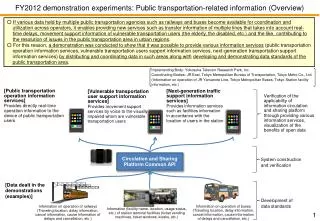
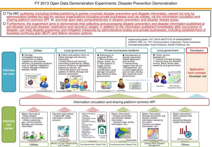
FY 2013 Open Data Demonstration Experiments: Disaster Prevention Demonstration ○ The MIC publishes (including limited publishing to parties involved) disaster prevention and disaster information, owned not only by administrative bodies but also by various organizations including private businesses such as utilities, via the information circulation and sharing platform common API to promote open data comprehensively in disaster prevention and disaster related areas. ○ Furthermore, the experiment aims to demonstrate that collecting and processing disaster prevention and disaster information published at pre-disaster and post-disaster (restoration and recovery) stages, in addition to the information published immediately after occurrence of disaster, can help disaster prevention and mitigation measures by administrative bodies and private businesses, including establishment of business continuity plan (BCP) and lifeline recovery actions. Implementing bodies: NTT DATA INSTITUTE OF MANAGEMENT CONSULTING, Inc., NTT Communications Corporation, Pasco Corporation Corresponding bodies: Kyoto Prefecture, Ibaraki Prefecture, etc. Developers Local government Private businesses/residents Local government Utilities Information user • ● Damage investigation/recovery construction of utilities • Speed up and improve efficiency of grasping situations such as highway regulations • Share damage conditions between utilities • ● Collect and publicly inform of lifeline damage and recovery information • Collect failure and recovery information published by utilities, improve efficiency of aggregation process by officials, etc. • Eliminate delays and missed updates of lifeline damage and recovery information • ● Citizen service development • 1) Training and web services • Training using the WebGIS service, which utilizes data owned by local governments Application from contests - Developer site • ● Refinement of corporate BCPs • 1) Risk evaluation of offices, stores, etc. • 2) Risk analysis of supply chains • Detailed risk consideration using damage simulation data owned by local governments • ● Development of disaster prevention related application and services • 1) Homecoming support map service • Development, etc.,of useful applications and services utilizing data owned by local governments Road closed to vehicles Recovered area Homecoming support map service High possibility of building collapse PR Residents DIG (Disaster Imagination Game) Private businesses Utilities Facilities Department Residents, etc. Local public entities Estimated number of buildings which would be fully destroyed in South Kanto Earthquake Information circulation and sharing platform common API Information owner [Static information] - Road network [Dynamic information] - Lifeline (electricity, gas, communication) damage and recovery information [Dynamic information] - X-band MP radar information (rainfall amount) [Static information] - Disaster prevention and disaster related information (Hazard maps, facility information, etc.) [Static information] Disaster prevention and disaster related information owned by the nation (Various simulation information, etc.) [Static information] Other statistics and disaster prevention/disaster related information [Static information] - Facility information - Evacuation center information (Capacity, facilities, etc.) - Hazard maps [Dynamic information] - Evacuation center information (Open/close, number of evacuees, etc.) - Road closed, etc. Roads Evacuation centers Statistics information X-band MP radar Lifeline information Expected seismic intensity Hazard maps Utilities Local government (Kyoto Pref.) Cabinet Office (Disaster Management) Others Ministry of Land, Infrastructure and Transport Local government (Ibaraki Pref.)