Download
1 / 62
620 likes | 933 Views
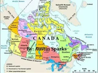
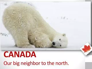
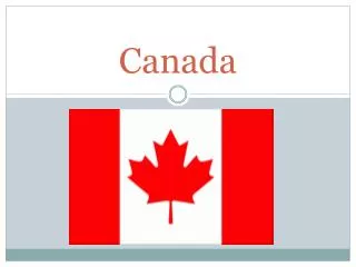
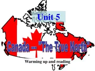
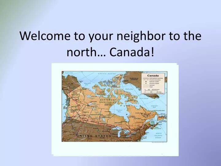
Welcome to your neighbor to the north… Canada!. Instead of states, Canada is divided up into 13 regions called, provinces or territories. Canada Overview. Canada is the second largest country in the world, after Russia. Due to its vast area Canada features a variety of climates and terrains.

E N D
Instead of states, Canada is divided up into 13 regions called, provinces or territories.
Canada Overview Canada is the second largest country in the world, after Russia. Due to its vast area Canada features a variety of climates and terrains. • British Columbia has a wet climate on its Pacific coastline, near-desert conditions in the interior, and cooler temperatures in the high elevations of the Rocky Mountains. • The provinces of Alberta, Saskatchewan, and Manitoba are dominated by southern prairies and northern forests and tundra. • Much of northern Canada—including parts of the Yukon, Nunavut (a new territory created in 1999), and Northwest Territories—is uninhabited because of the arctic climate and permanently frozen ground. • The Great Lakes moderate the climate of southern Ontario, where summers are hot and humid but winters bring snow and freezing temperatures. • East of Ontario is Québec, Canada's largest province. The Canadian Shield—a huge, U-shaped, rocky expanse surrounding the Hudson Bay—covers most of Québec and includes thousands of miles of forest. Much of the province's timber, mining, and hydroelectric wealth is found there. Although the Appalachian Mountains extend into northern New Brunswick, most of the Atlantic provinces' interior terrain is low and flat. This landscape has plateaus, valleys, and rocky terrain along the coast.
Parlez-vousFrançais? French colonists arrived in Canada in the 1600s, settling along the Saint Lawrence River in the territory they called New France. During the 1600s, Britain fought with France for the territory. In 1763, the Treaty of Paris gave Britain control over New France, which was renamed Québec. At about the same time, British Loyalists who had left the 13 colonies after the American Revolution also began settling in the area. As a result, English and French are the official languages in Canada. Most provinces use English, but in Québec, more than 8 out of 10 people speak French as a first language. The French spoken in Québec is slightly different from what you would hear in France. Also, native groups speak their own languages; the Inuit use a language called Inuktitut, which is very complex and hard to learn. Some helpful French phrases: ~Hello : Salut (SA-loo) ~Good-bye : Au revoir (OH rev-WAHR) ~Please: S’il vous plaît (SEEL voo play) ~Thank you: Merci (mare-SEE) ~Yes: Oui (wee) ~No: Non (noh)
Canada’s Government • Canada is a confederation with a parliamentary democracy; its government is similar to the United Kingdom's but also has a federal system like the United States. The federal government is responsible for national defense, international relations, the banking system, the criminal code, and the indigenous (native peoples) populations. The provinces are responsible for education, health care, and welfare. The greater resources of the federal government have led to its involvement in matters originally provincial (e.g., employment, insurance, and medicare). • Ceremonial duties of the head of state are performed by the governor-general (currently Michaëlle Jean), who represents Queen Elizabeth II. Canada's federal Parliament is made up of a Senate composed of as many as 105 senators appointed by the governor-general upon the prime minister's recommendation. The Senate rarely exercises its full powers.T he elected, 308-member House of Commons is the real legislative power. The prime minister (currently Stephen Harper) heads the government The leader of the party that gains the most seats in the House of Commons becomes the prime minister. Parliamentary elections are held at least every five years. The voting age is 18. • Canada's major political parties include the Liberal Party, the Conservative Party, the Bloc Québécois, and the New Democratic Party.
Canada has one of the strongest economies in the world. It is a leader in the production of gold, silver, copper, uranium, nickel, lead, oil, natural gas, agriculture, wood pulp, and timber-related products.
Canada's currency is the Canadian dollar (CAD). Canadians refer to the one-dollar coin as the loonie, after the image of the waterbird (the loon) minted on the coin. Likewise,the two-dollar coin is called the toonie.
Canada has two national sports: ice hockey in the winter http://www.youtube.com/watch?v=QrtCcXXNcGA and lacrosse in the summer. http://www.youtube.com/watch?v=QrtCcXXNcGA
The Arts Native American tribes are reviving traditional arts, many of which began before European settlers arrived. These include clothing decorated with paint, beads, and porcupine quills; jewelry; leatherwork; woodwork; and feather work. The ocean greatly influences Atlantic Canadian songs, art, poetry, and prose as well as folk festivals and other community events. Prince Edward Island is the birthplace of Lucy Maud Montgomery (author of Anne of Green Gables) and a popular place for those interested in seeing sites in her books. Montréal's annual jazz, comedy, and film festivals are popular attractions. The Canadian filmmaking industry is known for its innovation. Contemporary dance and traditional ballet companies enjoy wide audiences and critical acclaim.
Our first stop, will be Nova Scotia. Nova Scotia is Latin for “New Scotland.” It was named by King James I of England in 1621. Nova Scotia is the second-smallest province in Canada, after Prince Edward Island. It’s about twice the size of Massachusetts and is shaped like a lobster. Even though most of Nova Scotia is surrounded by water, it is attached to the mainland by a narrow isthmus (strip of land). Nova Scotia has temperatures that are generally warm in the summer and cold in the winter. Average temperatures in the summer are around 65°F. July is the hottest month. The average temperature in January, the coldest month is 25°F. The moist air off the Atlantic creates heavy fog in the early summer, particularly around the Bay of Fundy. It also brings frequent rain and ice storms. The province usually receives about 70 inches of snow each year.
The majority of the wildlife in the Maritime Provinces is made up of small animals like foxes, otters, and porcupines. Common larger animals include white-tailed deer, moose, wildcat, and black bear. The waters around the provinces are home to seals, cod, and salmon as well as many waterfowl such as heron, loon, and duck. http://www.youtube.com/watch?v=vWTphlw6o4M
John Cabot was an Italian explorer working for the king of England. On a voyage that he thought would take him to China, Cabot landed in North America and sailed to Cape Breton Island in 1497. Cabot claimed the entire land for England. He returned home with stories of waters full of so many fish that you could reach out your hand and catch one. Fishermen quickly started sailing for Nova Scotia to try their nets in this new territory. Upon arriving, they met the Mi’kmaq people and began trading metal tools and cloth for fur. In 1534, Jacques Cartier explored the area and claimed all of it for France. French fishermen poured in as well, and they also set up a bustling fishing and shipping business. The French got along well with the Mi’kmaq and the two groups worked together often. The Mi’kmaq taught the newcomers how to build canoes and snowshoes and survive in the cold weather. However, England and France were both more interested in the fish and fur the land could provide than the land itself. So neither country set up a permanent settlement, and for a while, they worked side by side without many problems. The French fishermen named the region L’Acadie, or Acadia.
The majority of people in Nova Scotia live along the coast or in the valleys. About 80 percent of the population is of British ancestry, and one-third of those are Scottish. As a result, Gaelic (the traditional language of Scotland and Ireland) is still spoken, particularly by Capers—the residents of Cape Breton Island. Nova Scotia is also home to the oldest and largest African Canadian population in the country. Many of their ancestors came from the American colonies during and after the Revolutionary War and the War of 1812. There are more than 30,000 First Nations peoples in Nova Scotia. Smaller groups include Acadians and Métis. Eleven percent of the population is Acadian, descendents of the original French settlers. The Acadians speak French as their first language and generally live on the northeast coast of Cape Breton Island or on the western mainland. There are about five thousand Métis.
Dill’s Giant Pumpkins Windsor, Nova Scotia, is known as the Pumpkin Capital of the World. Around 20 years ago, Howard Dill began growing a new variety of pumpkin—the Atlantic Giant. Dill’s giant pumpkins are the largest in the world, some weighing in at more than 1,500 lbs! The town began holding an annual pumpkin festival and weigh-off in the month of October. In 1999, festival organizers started the Annual Pumpkin Regatta. Contestants work in teams to hollow out the insides of their giant pumpkins, decorate them, climb inside, and then race them across Lake Pesaquid. The first pumpkin-paddler to cross the 550 yard distance wins. http://www.youtube.com/watch?v=DzJVFdB4BRo
Our next stop… New Brunswick! New Brunswick is divided up into three main regions. The northwestern region is part of a large plateau (high, flat land). Central and eastern New Brunswick is covered in gentle, rolling hills, which slope down to the coastal region in the south. The coast is quite marshy with many rivers and streams leading to the sea. The largest of these is the Saint John River, which measures 418 miles long. The Bay of Fundy is the province’s largest bay and separates New Brunswick from Nova Scotia. An isthmus (narrow strip of land) connects southeastern New Brunswick with Nova Scotia. Prince Edward Island lies to the east of the province across the Northumberland Strait. http://www.youtube.com/watch?v=yRbvvzK-ll0
The world’s first individually wrapped chocolate bars were made in 1910 in Saint Stephen—Canada’s Chocolate Town! They sold for five cents apiece. The small town of St. Stephen prides itself on being Canada’s Chocolate Town. The annual Chocolate Festival, along with the Chocolate Museum, celebrates the town’s long chocolate and candy-making history, which started in 1873 when the Ganong brothers began making their own homemade chocolates to sell in their grocery store. For more than twenty years, St. Stephen has held the festival every August. Chocolate lovers can wander through the museum, watch demonstrations, and learn how to make hand-dipped chocolates themselves. Best of all, though, are the many chocolate taste testing contests!
The New Brunswick Highland Games and Scottish Festival is held every year at the end of July in Halifax. The event is kicked off with a tattoo (military drum performance). Traditional Scottish music, dance, and sports competitions follow over the next few days. Sword dancing and the caber toss are two of the most popular events. A sword dance is a war dance performed solo over one or two swords lying on the ground. The goal is to successfully complete the dance without touching or moving the sword(s) at all. A caber is a log 20 ft. long and weighing around 120 lbs. Contestants grasp the end of the caber in their cupped hands, brace it vertically against their shoulder, and run forward throwing it end over end. The object is to throw it as straight as possible so the caber falls directly in front of the contestant.
The famous Reversing Falls are a series of waterfalls on the Saint John River. The incoming tides from the Bay of Fundy force the falls to reverse their course and flow uphill twice a day, defying the force of gravity! http://www.youtube.com/watch?v=oRtnasSBYSI
On to Prince Edward Island As the smallest province in the nation, Prince Edward Island covers a total area of 2,185 sq miles. It’s about the same size as the state of Delaware. Every place you can go on the island is less than 10 miles from the ocean. Prince Edward Island is located in the Gulf of St. Lawrence and is shaped like a crescent moon. The province is separated from its fellow Maritime Provinces—Nova Scotia and New Brunswick—by the Northumberland Strait. All but one lake and one river in the province are saltwater, and the island’s stunning beaches stretch for close to 500 miles. The coastline is dotted with lagoons, bays, and sandstone cliffs, while the inland is covered in sandy dunes and rolling hills. Hillsborough Bay and Malpeque Bay are the two largest bays in the province.
Prince Edward Island farms are known for their unusual red soil. The redness comes from the soil’s high levels of iron-oxide (rust). Crops grow so well in this soil that Prince Edward Island was nicknamed The Garden Province. Potatoes are the most important crop and are responsible for almost half the island’s total agricultural output. Prince Edward Island supplies Canada with more potatoes than any other province. Potatoes are shipped to 30 different countries all over the world. Cattle, pigs, and tobacco are also important crops, and dairy farms are found throughout the province. http://www.youtube.com/watch?v=dS0J4OHZQAk
Prince Edward Island College of Piping The majority of the Island’s population descends from either Scottish or Irish settlers. These descendents take great pride in the establishment of the College of Piping and Celtic Performing Arts of Canada in Summerside. This college is the only one of its kind in North America. Open year-round, the college offers instruction in traditional Celtic disciplines such as dance, drumming, and Highland bagpiping. As part of its goal to preserve the island’s Celtic culture, the College of Piping hosts an annual Celtic Festival with evening concerts all summer long. http://www.youtube.com/watch?v=-rNFXnU3qjk
Newfoundland and Labrador Viking explorer Leif Eriksson set out from Greenland and landed in North America around the year 1000. Eriksson became the first known European to explore North America. He and his men sailed in two wide, round ships known as knorrs. They explored what is now Labrador and also founded the first known European settlement in North America at L’Anse aux Meadows in 1003. The Vikings were impressed with the plentiful salmon in the waters, and they named Labrador Markland, meaning “woodland.” More Viking settlers arrived soon after Eriksson’s voyage. They had many conflicts with the native peoples and struggled with the harsh climate, so they abandoned their settlements and returned to their homeland.
L’Anse aux Meadows is the site of a Viking settlement that was discovered in 1960. It is the only real Viking settlement in North America outside of Greenland. The settlement dates back to the year 1000 when a Viking ship from Greenland landed on the coast of Newfoundland’s Great Northern Peninsula. There the explorers built the settlement that became L’Anse aux Meadows, and the remains of homes, workshops, and even a forge (blacksmith shop) can still be seen today. It was declared a UNESCO World Heritage Site in 1978 and is now open to the public. Volunteers stage Viking reenactments as well as demonstrations of what daily life was like more than a thousand years ago. http://www.youtube.com/watch?v=AzzAs1noEcA
Black bear, fox, woodland caribou, and otter are all animals native to Newfoundland and Labrador. Labrador has a wider variety of wildlife. There you can also find polar bear, wolves, and mink. Seabirds such as puffins and gulls are common all along the coasts, but no snakes or reptiles can be found anywhere in the province.
Next stop, Quebec Three times larger than France, Québec. It is the largest province in Canada and is second in size only to the territory of Nunavut. The three main geographic regions in Québec are the St. Lawrence Lowlands, the Appalachian Highlands, and the Canadian Shield. Did you know? • Québec gets its name from the Algonquin word kebec, meaning “the place where the river narrows.” • Québec produces 75 percent of the world’s maple syrup! • Montréal is the second-largest French-speaking city in the world, after Paris, France. • Canada’s first ice hockey team was formed in Montréal in 1877. • Two Montréalers, a reporter and a photographer, invented the game Trivial Pursuit in 1980. • Québec is the only province in Canada where English is not an official language. French is the only official language.
In Search of Gold In 1534, King Francis I of France sent explorer Jacques Cartier to the Gulf of St. Lawrence in search of gold. Cartier claimed the land for France and made several trips to and from Europe. He brought back what he thought was gold and diamonds, but which actually turned out to be pyrite (fool’s gold) and quartz. France eventually gave up on finding riches, but French trappers soon realized that fur was the real treasure in the new land. By the early 1600s, the French trappers had started a highly successful fur trading industry with the native bands (tribes) in the area. In 1608, Samuel de Champlain established a fort at a point on the St. Lawrence River . The new settlement became known as Québec.
New France Though fur traders did very well in the new colony, few other French people wanted to leave their homes for a new land that was not as good for farming. To encourage more farmers to move to New France, the government set up the Company of One Hundred Associates. This company gave portions of land to seigneurs (agents or landlords). The seigneurs promised to divide up their land between farmers who would pay them a fee in exchange for the right to work and live on the land. There were many more men than women living in the colony and so the king sent hundreds of single women to New France as brides for the soldiers, traders, and farmers living there. These women were known as filles du roi (daughters of the king), and as they married and started families, the population of New France soared.
Cirque du Soleil In 1984, the government of Québec was in search of entertainment acts to celebrate the 450th anniversary of French explorer Jacques Cartier’s arrival in Canada. In response to the search, two street entertainers, Guy Laliberté and Daniel Gauthier, founded the Cirque du Soleil (Circus of the Sun). Cirque du Soleil is made up of human performers and each show tells a story accompanied by original musical scores. Acrobats, trapeze artists, and jugglers are some of the artists involved. http://www.youtube.com/watch?v=jhWQLV-S3js&feature=related
Sugar Shacks Quebecers know it's officially spring when the sap begins to flow in the maple trees. Every spring, many Quebecers travel into the countryside to visit a cabane a sucre (sugar house) for the traditional making of maple syrup. Families gather in late March or early April and feast together on a variety of foods made with maple syrup. Popular dishes include oreilles de crisse (fried strips of salt pork), sugar pie, omelettes, and grands-pères (dumplings), all made with sweet, homemade maple syrup. But the favorite treat for kids is maple taffy. They go outside and throw globs of maple syrup on the snow and then scoop the hardened treats up again on little sticks. Families follow their feasts with traditional dances, music, and sleigh rides. Many towns in Québec hold maple festivals. http://www.youtube.com/watch?v=fxinJbbFL00&feature=PlayList&p=C988FE8F556B7655&playnext=1&index=5
Ontario, the heartland province Ontario is the second-largest province in Canada and covers 415,598 sq miles. Ontario has many rivers and rocky landscapes, so you can find lots of rapids and waterfalls in the province, including the famous Niagara Falls on the border of Ontario and New York.
The War of 1812 On 18 June 1812, the United States of America declared war on its mother country, Great Britain. This declaration included Britain’s colonies in North America. U.S. General William Hull’s forces invaded Upper Canada in the area that is now Windsor, Ontario, on July 12, 1812. The attack was an attempt to weaken British control in North America. Canadian forces immediately fought back. Many aboriginal (native) groups joined these forces, helping to drive out the American invaders and put down several of the initial attacks. Loyalist settlers, who were people who fought for the British during the American Revolution and later fled to Canada, also took up arms and fought on the Canadian side. British and Canadian troops kept the Americans at bay until the United States won the Battle of the Thames near Chatham, Ontario, on October 5. 1813. Leaders signed the Treaty of Ghent in 1814. The war was officially over, and neither side had given up any land, but borders between the United States and Canada were firmly set by this treaty.
First Nations, Métis, and Aboriginal Peoples Close to three percent of Ontario’s population (around 309,000 people) is aboriginal (native). There are a total of 134 First Nations reserves (land set aside for native use) within the province. The Six Nations of the Grand River Reserve in southern Ontario is the most populous reserve in Canada. The Six Nations reserve has a population of more than 20,000 people, representing the Mohawk, Cayuga, Tuscarora, Oneida, Onondaga and Seneca First Nations. Residents elect members to a governing council which oversees reserve affairs. Every year the reserve hosts the Wahdakeh, or Six Nations Native Pageant, which is an outdoor forest theatre. The pageant draws thousands of visitors and features live performances, food, and crafts. http://www.youtube.com/watch?v=1guvKB0Rwgw&feature=PlayList&p=6513E4AD818D754C&playnext=1&index=34 Métis (people with both European and native heritage) see themselves as a distinct nation of aboriginal (native) peoples. The Métis Nation of Ontario (MNO) was formed in 1994 with the goal of bringing Métis from all over Ontario together to preserve their culture and promote their interests and wellbeing. The MNO has developed education, health care, housing, youth, and numerous other programs to help its members achieve their goals in life. Currently the MNO Cultural Commission is sponsoring an oral history project in which Métis youth will hold storytelling sessions with Métis elders, recording the histories and stories of their people.
Manufacturing Ontario leads the nation in manufacturing, producing more than half of all goods manufactured in Canada. Manufacturing also makes up the majority of Ontario’s economy. Many of the products manufactured in Ontario are sold to foreign markets, particularly to the United States since no tariffs (fees) have to be paid on goods sold between the two countries. Automobile and transportation vehicles are leading manufactured goods Agriculture Ontario is Canada’s top agricultural province. The southwest region is the heart of the agricultural industry, since northern Ontario’s soil is rocky and not suited to farming. Beef, dairy, fruit, corn, and mixed farms are all found within the province. Hay, oats, corn and other grains are important crops, while peaches, grapes, and cherries are grown in the Niagara region. There are two main dairy regions, near Toronto and Ottawa. Mining Around 50,000 Ontarians work in the mining industry, the most of any province in Canada. Copper, nickel, zinc, platinum, and silver are abundant in Ontarian mines. Ontario also produces half of Canada’s gold, mostly from mines in the north of the province. Southern mines produce salt, clay, and gravel. The Lake Huron area is rich in natural gas and petroleum. It even has a town called Petrolia, which was once the center of the gas industry. .
Manitoba; The Last, Best West The Canadian national government encouraged westward expansion after Manitoba became a Canadian province in 1870. The area would need large numbers of immigrants to live and work the land to become a developed province. The government began an aggressive campaign to recruit immigrants from all parts of the world. The most common slogan used in such campaigns referred to Canada as “the last, best west.” Thousands of Germans, Ukrainians, and other eastern Europeans came to Manitoba to take advantage of the free land. Russian Mennonites (peaceful, independent Protestant groups) fled Russia in search of religious freedom and exemption (release) from military service, bringing with them new farming practices. Icelandic fishermen came to Manitoba in the 1870s and set up a fishing village on the western shores of Lake Winnipeg. They named their village Gimli, which means “paradise” in Icelandic. With the rapid growth of the Canadian railroad, workers were always needed. Many of those workers were Chinese immigrants, who often sent money home to their families back in China. All of these groups brought their unique heritages to the young province, creating an early blend of cultures in “the last, best west.”
Curling Curling is a very popular sport in Manitoba! Curling was developed in Scotland in the Middle Ages. Manitoba’s earliest settlers were Scottish, who brought the sport to their new home. It is played on long, narrow sheets of ice between two teams, each with four curlers. Players attempt to slide large, smooth stones down the ice lanes to the house (target). Two players follow the stone with brooms, sweeping its path so it will slide smoothly and in a straight line. The team with the most stones near the centre of the house wins. Bonspiels (curling tournaments) are highly attended events and the Granite Curling Club centered in Winnipeg is the oldest club in Western Canada. http://www.youtube.com/watch?v=CM5mFH3_Qhs
Saskatchewan Saskatchewan is shaped like a rectangle and all four of its boundaries are straight lines. There are three geographic regions in the province: the Canadian Shield, the Plains, and the Hills. The Canadian Shield stretches across the northern third of Saskatchewan and is made up of ancient rock that used to be covered by glaciers. It’s now a very rugged, forested area. The Plains region is in central and southern Saskatchewan. Most of the province’s cities are located in the Plains as well as the most productive farmland. The Hills, Saskatchewan’s third region, is in the southwestern corner of the province. These steep hills make up the highest land in Saskatchewan. The Saskatchewan River runs from the west to the east and is the province’s most important waterway. Half of Saskatchewan's land is covered in forests, while one-third is used for farmland.
Beaver Fur In the late 1600s, Europeans reached the area that is now Saskatchewan in search of beaver fur. At the time, beaver fur was used to make hats that were popular in Europe. Hudson’s Bay Company traders realized that the native inhabitants of the land were best at trapping beavers, so they set up trading posts where natives could bring the beaver pelts and trade them for manufactured goods such as cloth, guns, and metal tools. Soon French fur traders joined in the business. First Nations peoples traded steadily with both groups and often served as guides to the newcomers. Many European settlers married aboriginal (native) women and had families. Their children were known as Métis (mixed blood). Fur hunting and trading quickly became a way of life for the Métis, who grew up in the new settlements.
The Roughriders The Saskatchewan Roughriders are a Canadian Football League (CFL) team based in Regina. They are the only professional sports team in Saskatchewan. Originally, the Roughriders were a rugby team founded in Regina in 1910. In 1948, they became the Regina Roughriders. Now the Riders play for the CFL’s West Division, and their colors are green, white, black, and silver. The team has gone to the Grey Cup (CFL championship) seven times in the history of the club and has captured the national title twice, once in 1966 and again in 1989. Roughrider fans take their roles seriously, so home games are always highly attended. Some fans even make green “helmets” out of carved out watermelons and wear them during the games! Prairie Fiction Saskatchewan has a lively and long literary tradition. In 1947, W.O. Mitchell published his novel Who Has Seen the Wind. The book focuses on a young boy named Brian growing up in the Canadian prairies during the Great Depression and has since become a classic of Canadian literature. Often called the Mark Twain of Canada, Mitchell is considered a pioneer in what became an entire genre of literature—prairie fiction. In 1969, Saskatchewan poet Anne Szumigalski helped found the Saskatchewan Writers Guild to help encourage and promote Saskatchewan writers. Four years later, Szumigalski also helped start Grain, a provincial literary journal. For more than 30 years, Grain has continued to publish the best in new literature and art from Canada and around the world
Alberta This region has fertile farmland, on which ranchers raise cattle and farmers grow wheat and canola. Southeastern Alberta is often known as the “badlands,” because wind, rain, and the Red Deer River have eroded the rock to form strange formations called hoodoos. Hoodoos are tall pillars of rock shaped like toadstools that grow out of the cliffs and gullies in the area. The badlands are also known for dinosaur fossils, found in layers of rock which have been eroded by wind and rain over the centuries. The Rocky Mountains region runs along Alberta’s southwestern border and includes both the highest point in the province, Mount Columbia at 12,294 ft, and the highest town in Canada, Lake Louise at 5,052 ft.
1988 Winter Olympics In 1988, on the third try, Calgary, Alberta, won the right to host the Winter Olympics. A few years before, the city had built the Saddledome Arena to house their National Hockey League (NHL) team, the Calgary Flames. The Saddledome was a perfect venue (location) for Winter Olympics indoor ice events and helped the city win the bid. Even though Calgary has long been growing rapidly, until the Olympics were held in the city, it had been known mainly as a “cow town.” Hosting the Olympics brought the attention of the world to Calgary. The 16-day event was a huge success, and the city is still benefiting, as athletes continue to come to the Saddledome and other facilities to train for winter sports. Skaters say Calgary has the best and fastest ice in the world.
The Calgary Stampede The Calgary Stampede is a 10-day rodeo held in Calgary each year in the second week of July. It is known as The Greatest Outdoor Show on Earth, and every year more than a million rodeo competitors and fans from around the world descend on Calgary. The stampede includes a festival and exhibition, complete with a parade, a ferris- wheel, concerts, and chuck wagon races. First Nations peoples set up a traditional village to display their culture and crafts, while ranchers and farmers come to display their livestock and produce. Bronco riding and barrel racing are popular sporting events, while the annual pancake breakfast is always a favorite. Stampede volunteers serve up thousands of pounds of bacon, sausage, and pancakes to hungry spectators! http://www.youtube.com/watch?v=K7Igpye3kt0
Black Gold Rush After World War II, Alberta experienced its own type of “gold rush.” On 13 Feb 1947, a geyser of oil spewed up into the sky at Leduc, south of Edmonton. Soon after, oil was discovered in towns across the province. The discovery of enormous oil reserves took Albertans by surprise and began the transformation of Alberta’s agriculturally-based economy into one focused on oil and industry. Alberta’s “black gold” rush fueled the growing transportation and construction industries, providing oil for markets across the nation and the United States as well. Edmonton and Calgary quickly became Alberta’s main commercial and industrial cities. Because the Albertan economy was so tied to the price of oil, it experienced many booms and busts. In order to protect itself from the instability of the world oil market, Alberta expanded its industries into other profitable areas including forestry and tourism.
British Columbia British Columbia is often referred to as a paradise because of its remarkable natural beauty. Located between Alberta and the Pacific Ocean, British Columbia is the westernmost of Canada’s 10 provinces. Most of the province is covered by the Canadian Cordillera mountain range and by a portion of the Rocky Mountains. Much of this mountain area is covered by forests as well, and British Columbia grows the largest trees in Canada. The northeastern corner of the province is called the Peace River district and is mostly made up of prairie land.
Gold Rush Days In 1858, gold was found on the banks of the Fraser River in Fraser Canyon, and the first gold rush began. More than 30,000 people from America, Europe, and Asia swarmed British Columbia, trying to strike it rich. The second gold rush started three years later in the Cariboo region of British Columbia. The gold industry transformed the region. Mining boomtowns (rapidly growing towns) appeared, such as Yale and Barkerville. As a result of all the money and people pouring into the area, the British created the new colony of British Columbia. Roads were quickly built and a local government set up. However, the new colony was not managed well. By 1866, British Columbia was in so much debt that the government chose to unite it with the colony of Vancouver Island and combine the two economies. The new colony was called British Columbia, and Victoria was its capital.
Asian Immigration The gold rush years brought immigrants from China, Japan, and India to British Columbia. They worked hard and were largely responsible for the completion of the Canadian Pacific Railway, which linked British Columbia with the eastern provinces. After the completion of the railway, the government severely limited Asian immigration and made those who immigrated pay a high tax just to enter the province. Asians were barred from getting better education and better employment. During World War II, when Canada was at war with Japan, the Security Commission Council ordered all Japanese living on the west coast to move to work camps further inland where they were forced to work in road crews or on other people’s farms. The government took over and sold Japanese-owned businesses, homes, and farms and then kept the money. At the end of the war, these people were given the choice of going back to Japan or staying in Canada. Most people decided to stay, though it took many more years for people to accept them and for the government to give them the same rights as other Canadians.
Totem Poles For thousands of years, First Nations peoples all along the coast of North America have developed the art of totem pole carving. British Columbia is famous for its many totem poles, including many of the tallest and largest ones in the world. The word “totem” comes from the Ojibwa word odoodeman, meaning a “family symbol.” Totem poles are usually carved out of large cedar trees. The designs centre around families or clans and symbolize individual family members, stories, or legends. The figures are arranged one on top of the other all the way up the pole and are often painted bright colors. Native peoples gathered to celebrate the raising of a new totem pole. Together they helped raise the pole and performed dances in honor of the event. http://www.youtube.com/watch?v=R_-q_z0x9rI
Yukon The territory is shaped like a triangle and shares its western border with Alaska. The landscape of the Yukon is made up of a series of high plateaus (flat highlands), surrounded by long mountain chains and deep river valleys. Most of the Yukon has a subarctic climate with long, cold winters and short, mild summers. Yukoners joke that there are only two seasons in the territory: this winter and last winter! Because the climate is also very dry, snowfall is not usually heavy. Temperatures are warmest in the south, where the average winter temperature is -2°F and the average summer temperature 57°F. The northern portion of the territory, along the Arctic Coast, has an arctic climate and is much colder than the south. This arctic land is called permafrost, meaning the ground is permanently frozen year-round, so very few plants can survive there. In far northern Yukon, it is dark for almost the entire winter. However, during the short summer months, the sun doesn’t set at all.
Wildlife Unlike other areas in Canada, the Yukon has remained home to many of the animals who lived there before Europeans arrived. Herds of caribou, grizzly and black bears, wolves, and coyotes are all still found across the territory. Eagles, falcons, and hawks also make their homes in the Yukon. In the north, near Herschel Island, polar bears and walruses are common.
Yukon Quest The Yukon Quest is a 1,000 mile dogsled race that is held every February. The race route stretches through the Arctic wilderness, from Whitehorse, Yukon, to Fairbanks, Alaska. The route follows the path the gold rush and mail delivery took in the early 20th century. Each team has one person, a musher (driver), and fourteen dogs pulling the sled. The race lasts for two weeks and has one rest stop halfway along the course at Dawson City, Yukon. The Quest crosses frozen rivers and four mountain ranges and tests each musher and dog to the edge of their endurance. The winner takes home a little over $47,000 CAD ($40,000 USD). http://www.youtube.com/watch?v=tdPuzqzKf7I&feature=related
Northwest Territories The Northwest Territories has eight official languages: Inuktitut, French, English, Gwich’in, Cree, Chipewyan, Slavey, and Dogrib. During autumn and winter, the Aurora Borealis, or “northern lights,” are visible in the Northwest Territories. These colorful, dancing lights are caused by solar wind interacting with gases in the earth’s atmosphere. The Northwest Territories has two major climatic zones: the arctic and the subarctic. These two zones are separated by the tree line (the farthest north trees can grow). The arctic is north of the tree line, where most of the land is tundra and permafrost (permanently frozen ground). The subarctic is below the tree line, where there are some forests. The arctic has cool, short summers where the temperature stays around 50°F, and winter lasts at least nine months out of the year. The subarctic area has a longer summer, but winter in both zones is long and icy. Temperatures of -60°F are common throughout the territory in the winter months. During this time there are many blizzards and whiteouts (blizzards which make it impossible to see the horizon). Overall, the territory receives very little precipitation, and the arctic is so dry it is actually considered a desert. The Northwest Territories lies in the middle of Canada’s two other territories: the Yukon and Nunavut. http://www.youtube.com/watch?v=9Z1-LLZmrsY