Download
1 / 36

E N D
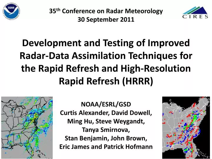
35th Conference on RadarMeteorology30 September 2011Development and Testing of Improved Radar-Data Assimilation Techniques for the Rapid Refresh and High-Resolution Rapid Refresh (HRRR)NOAA/ESRL/GSDCurtis Alexander, David Dowell, Ming Hu, Steve Weygandt, Tanya Smirnova, Stan Benjamin, John Brown, Eric James and Patrick Hofmann
Hourly Updated NOAA NWP Models Rapid Refresh (RR) replaces RUC at NCEP in 2011 WRF, GSI with RUC features 13km Rapid Refresh (mesoscale) 13km RUC (mesoscale) 3km HRRR (storm-scale) RUC – current oper Model, new 18h fcst every hour High-Resolution Rapid Refresh Experimental 3km nest inside RR, new 15-h fcst every hour
NOAA/ESRL/GSD/AMB Models • Summary of 2011 • Changes & Evaluation Activities • RR initialization (parent model/assimilation) • Latent heating strength (radar data assimilation) in RR • Reduced diffusion (no 6th order diffusion) • Raised pressure top • Increased min/max time step • Higher resolution SST data (0.083°)
HRRR Milestones • Inception over northeastern US Sept 2007 • Integration into CoSPA: Aviation Users Spring 2008 • Domain expansion to eastern US Mar 2009 • HCPF time-lagged ensemble inception May 2009 • HRRR WRF-ARW updated to v3.1.1 Oct 2009 • Domain expansion to CONUS Oct 2009 • HRRR WRF-ARW updated to v3.2 Apr 2010 • Forecast period extended to 15 hrs Apr 2010 • Real-time multi-scale reflect. verification June 2010 • Parallel (shadow) retrospective system Sept 2010 • Attained ~95% reliability Jun 2010 • Reduced latency to ~2 hrs Dec 2010
HRRR (and RR) Future Milestones • Conversion of all output to GRIB2 format Apr 2011 • Transition from RUC to RR parent model Apr 2011 • DOE-funded HRRR FTP site for energy industry May 2011 • Update to WRF-ARW v3.3.1 Nov 2011 • Reflectivity data assimilation at 3 km scale 2012 • Assimilate Radial Velocity at 3 km scale 2012 • Incorporate SatCast products at 3 km scale 2012 • HRRR demo @ESRL improves 2012-2014 • Rapid Refresh operational at NCEP 2011 • Ensemble Rapid Refresh (NARRE) at NCEP 2014 • HRRR operational at NCEP 2015? • Ensemble HRRR (HRRRE) at NCEP 2016?
HRRR (and RR) Future Milestones • Conversion of all output to GRIB2 format Apr 2011 • Transition from RUC to RR parent model Apr 2011 • DOE-funded HRRR FTP site for energy industry May 2011 • Update to WRF-ARW v3.3.1 Nov 2011 • Reflectivity data assimilation at 3 km scale 2012 • Assimilate Radial Velocity at 3 km scale 2012 • Incorporate SatCast products at 3 km scale 2012 • HRRR demo @ESRL improves 2012-2014 • Rapid Refresh operational at NCEP 2011 • Ensemble Rapid Refresh (NARRE) at NCEP 2014 • HRRR operational at NCEP 2015? • Ensemble HRRR (HRRRE) at NCEP 2016?
Radar Reflectivity Data Assimilation Radar Observations (WSR-88D) Reflectivity = SUM(Rain, Snow, Hail, etc…) Not a direct observation of individual hydrometeors and distributions Model Forecasts (WRF-ARW) Reflectivity = Diagnostic variable ESTIMATE Hydrometeors are prognostic variables in microphysics scheme(s) Reflectivity observation type does not correspond to a state variable Options: Specification of hydrometeors using some assumptions Use implicit condensate formation as a model forcing function Combination of A and B Others
Radar Reflectivity Data Assimilation • B. Use implicit condensate formation from > 0 dBZ 3-D reflectivity as a • forcing function in the model: Latent heating in microphysics (MP) • Latent heating rate in the absence of reflectivity observations • Outside of radar coverage => Use model MP • Below lowest elevation and above PBL top => Extrapolate obs down • Testing: • Rely upon other observation types (lightning, satellite) as proxy • Latent heating rate where 3-D reflectivity observation < 0 dBZ • Convective/precipitation suppression => Set MP latent heating = 0 • Testing: • If model environment supports convection this is not enough, • Need to force weak subsidence to avoid spurious convection
Radar Reflectivity Data Assimilation • B. Use implicit condensate formation from > 0 dBZ 3-D reflectivity as a • forcing function in the model: Latent heating in microphysics (MP) • (3) Latent heating rate for a given 3-D reflectivity observation > 0 dBZ • Application in planetary boundary layer (PBL)? => No, use MP value • Function of stability? => No • Testing: Reduce heating for more unstable environments • Vertical/horizontal location of heating? => Currently co-located • Testing: Vertical displacement (i.e. reflectivity trailing indicator) • Time-scale of condensation formation? => Currently 10 min • Testing: 5 min (2X), 20 min (1/2 X), 30 min (1/3 X) • Length of time to apply heating? => Currently constant for 20 min • Testing: Cycle in four 15-min periods with different values • Adjust microphysics heating rate? => Currently replace (specify) • Testing: Averaging or adding obs-based and MP heating
2011 Hourly HRRR Initialization from RR 15-h fcst 15-h fcst Hourly HRRR Interp to 3 km grid Lateral Boundary Conditions Interp to 3 km grid 18-h fcst 18-h fcst Use 1-h old LBC to reduce latency Initial Condition Fields 18-h fcst Use most recent IC (post-DFI) to get latest radar info 1-hr fcst DDFI DDFI 1-hr fcst 1-hr fcst Back- ground Fields Analysis Fields Reduced Latency: ~2h for 2011 Hourly RR 3DVAR 3DVAR Obs Obs Time (UTC) 11 z 12 z 13 z
Diabatic Digital Filter Initialization (DDFI) -20 min -10 min Init +10 min Backward integration, no physics Forward integration, full physics Apply latent heating from radar reflectivity, lightning data Obtain initial fields with improved balance, vertical circulations associated with ongoing convection RR model forecast • The model microphysics temperature tendency is replaced with a reflectivity-based temperature tendency. • Dynamics and microphysics respond to thermodynamic forcing. • Analysis noise is reduced by digital filtering.
00z 12 August 2011 Obs 00 hr HRRR forecasts RR – Radar data RR – No radar data
Obs 01z 12 August 2011 Obs 01 hr HRRR forecasts RR – Radar data RR – No radar data
Reflectivity 00z 12 August 2011 00 hr forecasts RR – Radar data RR – No radar data Convergence Cross-Section
Reflectivity 01z 12 August 2011 01 hr forecasts RR – Radar data RR – No radar data Convergence Cross-Section
20z 14 August 2011 Obs 00 hr HRRR forecasts RR – Radar data RR – No radar data
Obs 21z 14 August 2011 Obs 01 hr HRRR forecasts RR – Radar data RR – No radar data
20z 14 August 2011 00 hr forecasts Reflectivity RR – Radar data RR – No radar data Convergence Cross-Section
21z 14 August 2011 01 hr forecasts Reflectivity RR – Radar data RR – No radar data Convergence Cross-Section
HRRR Reflectivity Verification DDFI in 13-km RUC/RR (parent model) but not in 3-km HRRR Eastern US, Reflectivity > 25 dBZ 11-20 August 2011 CSI 40 km CSI 03 km RUC + Radar RR + Radar RUC + Radar RR + Radar RUC + No Radar RR + No Radar RUC + No Radar RR + No Radar Increase in forecast skill when reflectivity assimilated in parent model Neighborhood skill apparent on coarser verification grid (right)
HRRR Reflectivity Verification DDFI in 13-km RUC/RR (parent model) but not in 3-km HRRR Eastern US, Reflectivity at 03 km 11-20 August 2011 BIAS 40 dBZ BIAS 25 dBZ Optimal Optimal RR + Radar RR + No Radar RUC + Radar RUC + No Radar RR + Radar RR + No Radar RUC + Radar RUC + No Radar Higher bias when assimilating radar data, especially with the RR parent
HRRR Reflectivity Verification DDFI in 13-km RR (parent model) but not in 3-km HRRR Eastern US, Reflectivity > 25 dBZ 14-24 July 2010 BIAS 03 km CSI 40 km Optimal 2x Latent heating rate in RR 1x Latent heating rate in RR 1/3x Latent heating rate in RR 2x Latent heating rate in RR 1x Latent heating rate in RR 1/3x Latent heating rate in RR Increased latent heating forcing from parent increases skill and bias Increased skill not sustained at longer forecast times (> 4 hrs)
2011 Hourly HRRR Initialization from RR 15-h fcst 15-h fcst Hourly HRRR Interp to 3 km grid Lateral Boundary Conditions Interp to 3 km grid 18-h fcst 18-h fcst Use 1-h old LBC to reduce latency Initial Condition Fields 18-h fcst Use most recent IC (post-DFI) to get latest radar info 1-hr fcst DDFI DDFI 1-hr fcst 1-hr fcst Back- ground Fields Analysis Fields Reduced Latency: ~2h for 2011 Hourly RR 3DVAR 3DVAR Obs Obs Time (UTC) 11 z 12 z 13 z
Attempt application of 13-km DDFI again at 3-km 15-h fcst DDFI 15-h fcst DDFI Hourly HRRR Interp to 3 km grid Lateral Boundary Conditions Interp to 3 km grid 18-h fcst 18-h fcst Use 1-h old LBC to reduce latency Initial Condition Fields 18-h fcst Use most recent IC (post-DFI) to get latest radar info 1-hr fcst DDFI DDFI 1-hr fcst 1-hr fcst Back- ground Fields Analysis Fields Reduced Latency: ~2h for 2011 Hourly RR 3DVAR 3DVAR Obs Obs Time (UTC) 11 z 12 z 13 z
HRRR Reflectivity Verification DDFI in 13-km RR (parent model) AND in 3-km HRRR Eastern US, Reflectivity > 25 dBZ 14-24 July 2010 BIAS 03 km CSI 40 km Optimal 2x Latent heating rate in RR 1x Latent heating rate in RR 1/3x Latent heating rate in RR 1x Latent heating in RR and HRRR 2x Latent heating rate in RR 1x Latent heating rate in RR 1/3x Latent heating rate in RR 1x Latent heating in RR and HRRR Application of DDFI at both scales results in spurious convection Significant loss of skill
2011 Hourly HRRR Initialization from RR 15-h fcst 15-h fcst Hourly HRRR Interp to 3 km grid Lateral Boundary Conditions Interp to 3 km grid 18-h fcst 18-h fcst Use 1-h old LBC to reduce latency Initial Condition Fields 18-h fcst Use most recent IC (post-DFI) to get latest radar info 1-hr fcst DDFI DDFI 1-hr fcst 1-hr fcst Back- ground Fields Analysis Fields Reduced Latency: ~2h for 2011 Hourly RR 3DVAR 3DVAR Obs Obs Time (UTC) 11 z 12 z 13 z
13-km DDFI and sub-hourly cycling at 3-km 15-h fcst 15-h fcst Hourly HRRR Interp to 3 km grid Lateral Boundary Conditions Interp to 3 km grid 18-h fcst 18-h fcst Use 1-h old IC and 2-h old LBC Initial Condition Fields 18-h fcst 1-hr fcst DDFI DDFI 1-hr fcst 1-hr fcst Back- ground Fields Analysis Fields Reduced Latency: ~1h for 2012? Hourly RR 3DVAR 3DVAR Obs Obs Time (UTC) 11 z 12 z 13 z
t015 min t0 t045 min t030 min NSSL 3D mosaic reflectivity-based temperature tendency t045 min t060 min t030 min t015 min t0 HRRR composite reflectivity interpolation from RR,hydrometeor specification Reflectivity DA on 3-km (HRRR) Grid HRRR (3-km) grid produces convective storms explicitly Reflectivity-based temp. tendencies are applied during sub-hourly cycling(forward model integration only, no digital filtering)
2000 UTC 11 May 2011 Initial Temperature atLowest Model Level 1000 km (1) HRRR initializedwithout 3-km radar DA (2) HRRR initializedwith 3-km radar DA
more accuraterepresentation ofsystem maturity convection develops quickly (RR cycling, DDFI) obs 1-h fcstwithout 3-kmradar cycling 1-h fcstwith 3-kmradar cycling 1-h fcstwith 3-kmradar cycling CompositeReflectivity2100 UTC11 May 2011
more accurateforecast ofconvective system propagation obs 6-h fcstwithout 3-kmradar cycling 6-h fcstwith 3-kmradar cycling CompositeReflectivity0200 UTC11 May 2011
HRRR Reflectivity Verification DDFI in 13-km RR (parent model) AND 3-km HRRR 15-min cycling Eastern US, Reflectivity > 25 dBZ Select Cases May-July 2011 CSI 40 km BIAS 03 km CSI 03 km 1x Latent heating rate in RR and HRRR 1x Latent heating rate in RR 1x Latent heating rate in RR and HRRR 1x Latent heating rate in RR Optimal 2x Latent heating rate in RR 1x Latent heating rate in RR 1/3x Latent heating rate in RR 1x Latent heating in RR and HRRR Application of DDFI at 13-km and cycling at 3-km results improves skill Retention of convective-scale forcing/evolution remains a challenge Mesoscale environment often dominates storm-scale forcing
HRRR Forecast Behavior 2011 (1) Higher bias in convection over eastern US (2) Difficulty propagating/maintaining MCSs (3) Lead in convective initiation (early AM runs) (4) False alarm cases 2012 Targets (1) Lower peak bias in convection over eastern US (2) Less difficulty propagating/maintaining MCSs (3) Improve timing convective initiation (early AM runs) (4) Fewerfalse alarm cases RR/HRRR Model Development and Evaluation “Simplistic” 13-km latent heating No 3-km data assimilation “Smarter” 13-km latent heating 3-km radar data assimilation Implement