Download
1 / 1
10 likes | 169 Views
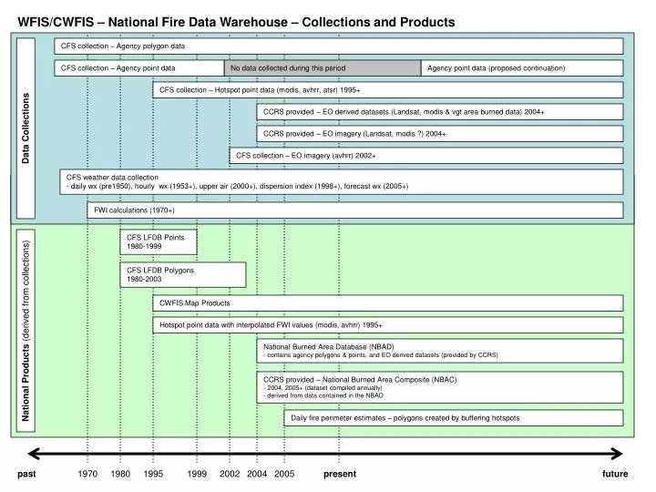
WFIS/CWFIS – National Fire Data Warehouse – Collections and Products. CFS collection – Agency polygon data. CFS collection – Agency point data. No data collected during this period. Agency point data (proposed continuation). CFS collection – Hotspot point data (modis, avhrr, atsr) 1995+.

E N D
WFIS/CWFIS – National Fire Data Warehouse – Collections and Products CFS collection – Agency polygon data CFS collection – Agency point data No data collected during this period Agency point data (proposed continuation) CFS collection – Hotspot point data (modis, avhrr, atsr) 1995+ CCRS provided – EO derived datasets (Landsat, modis & vgt area burned data) 2004+ Data Collections CCRS provided – EO imagery (Landsat, modis ?) 2004+ CFS collection – EO imagery (avhrr) 2002+ CFS weather data collection- daily wx (pre1950), hourly wx (1953+), upper air (2000+), dispersion index (1998+), forecast wx (2005+) FWI calculations (1970+) CFS LFDB Points 1980-1999 CFS LFDB Polygons 1980-2003 CWFIS Map Products Hotspot point data with interpolated FWI values (modis, avhrr) 1995+ National Products (derived from collections) National Burned Area Database (NBAD)- contains agency polygons & points, and EO derived datasets (provided by CCRS) CCRS provided – National Burned Area Composite (NBAC)- 2004, 2005+ (dataset compiled annually)- derived from data contained in the NBAD Daily fire perimeter estimates – polygons created by buffering hotspots past 1970 1980 1995 1999 2002 2004 2005 present future