Download
1 / 18
200 likes | 478 Views
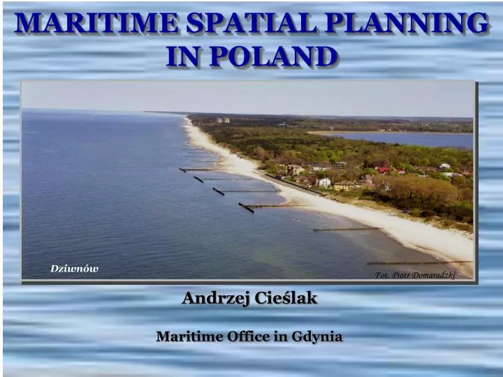
Dziwnów. Fot. Piotr Domaradzki. MARITIME SPATIAL PLANNING IN POLAND. Andrzej Cieślak Maritime Office in Gdynia. Polish Sea Areas EEZ – 22634 km 2 E; TS – 8682 km 2 ; ISW – 1991 km 2. Szczecin. Gdynia. Słupsk. BASICS. Maritime Administration in Poland

E N D
Dziwnów Fot. Piotr Domaradzki MARITIME SPATIAL PLANNING IN POLAND Andrzej Cieślak Maritime Office in Gdynia
Polish Sea AreasEEZ – 22634 km2 E; TS – 8682 km2; ISW – 1991 km2
Szczecin Gdynia Słupsk BASICS Maritime Administration in Poland responsible for spatial planning MINISTER OF INFRASTRUCTURE (minister responsible for maritime economy) National level 3 MARITIME OFFICES Regional level 3
Main Legal Basis • Act on Sea Areas of the Republic of Poland and Maritime Administration (1991, MSP through amendment in 2003) • Act on Spatial Planning and Management (2003) • Water Law (2001) • Act on Protection of Environment (2001) • Act on Nature Conservation (2004) • Act on Access to Information on Environment and its Protection, Public Participation in Protection of Environment, and on Environmental Impact Assessments (2008)
Main legal solutions • Within territorial sea and internal sea waters, the State is the sole owner of sea areas (soil beneath seafloor, seafloor, water column, air above) • Draft plans developed by Directors of Maritime Offices • Draft plans for territorial sea and int. sea waters must obtain agreement of neighbouring coastal communes • SEA required • Plan accepted and published as Ministerial Order by the Minister responsible for matters of building , spatial management and housing in agreement with the Minister responsible for maritime matters, after obtaining agreement of ministers of agriculture, national defence, environment, internal affairs
Main legal solutions (cont.) Plans to decide on: • assignment of the internal sea areas, territorial sea and the EEZ • prohibitions and limitations on the use of areas covered by the plan, taking into account the requirements of nature protection • the distribution of public investments • directions of development of transport and of technical infrastructure • areas and conditions of environment and historical heritage protection
Pilot MSP for the Puck Bay(Interreg III B /CADSES) Objectives • to test planning procedures and techniques (int. Alia 4D space, the including of sea/land & land/sea interactions), • to gather experience for improvements of legislation on MSP, • to obtain a basis for daily comprehensive and integrated management of the area (best available knowledge) The first picture shows the division of the planning area into „water basins” (corresponding to „terrains” in terrestrial planning) The second picture shows the uses (note that different uses may be located on the seafloor, water column and sea surface within the same „basin”, e.g. habitat protection, certain kinds of fishing, navigation &boating and windsurfing)
Lessons learned • We succeeded because • the team was multidisciplinary and engaged in parallel in a range of planning processes in Poland (at national and regional level) • there was a relative richness of information (especially nature, historical heritage) • there was a vision of the planned area • planning documents existed for all coastal communities • a wide range of stakeholders was involved before start of the planning exercise itself • Could be more successful if coastal communities better understood their stake in sea use planning • The hardest part of the work was the operationalisation of the 4D sea space and still insufficient data and information 11
Lessons learned • The longest part of the work was iteration and data collection • What surprised us most was the lack of spatial thinking among many researchers – they had difficulties with transferring their knowledge into spatial terms • Next time we would reserve more time for the planning process • We recommend especially good pre-planning preparation (production, collection of comprehensive environmental, economical, social etc. data) 12
Main improvements of law(to be shortly submitted to the Sejm (Polish Parliament) • Planning procedure started by Ministerial Order of the Minister responsible for maritime matters • Plan accepted by same Minister • Significantly extended procedures, especially for planning the territorial sea and internal sea waters, including public participation mechanisms • Inclusion of regional (voivodship) authorities in agreements of draft plans (including EEZ) • Plans to be produced in scales: • 1:200,000 and 1:400,000 – strategic plans (partly binding) • 1:25,000, 1:10,000 and for ports, harbours, bathing waters at least 1:2000 (exceptionally1:5000) – binding local law • Possibility of including important trans-coastline land/sea issues in respectively MSPs and terrestrial plans
Main improvements (cont.) • Plans to decide on: • Designation of sea basins • System of sea basins for sea transport incl. safety of navigation • Systems of protected sea areas, incl. environment, nature, landscape, historical and heritage protection and for health • Distribution of supra-local importance public investments • Sea basins closed temporarily and/or permanently and their protective zones • Distribution of mining areas • Limitations and principles of use of sea space • In case of strategic plans: designation of sea areas to be planned in scales 1:25,000 and larger In progress: work on Ministerial Order on required scope of MSPs in their textual and graphic parts, requirements concerning planistic materials, cartographic elaborations, symbols used in the plans, requirements concerning the standards and ways of documenting the planning work
Optimum location of wind farms Example of large-space issues 15
Some Follow-up Activities • The National Spatial Development Concept (final version early 2010) shall concern also the sea area – introduction of the experience of the Pilot Project into the Concept • Development of vision / strategic plan for the whole Polish sea area and, gradually, of sea use plans for all problem areas – int. alia within VASAB & HELCOM activities, BaltSeaPlan project • Development of a spatial vision/strategic plan for the whole Baltic Sea – within VASAB and HELCOM activities, EU projects • Further development / improvement of procedures (cross-border consultation), also joint planning with Russia (East-West Window projectand continuation) 17
Thank you Phot.: Piotr Domaradzki