Download
1 / 1
10 likes | 128 Views
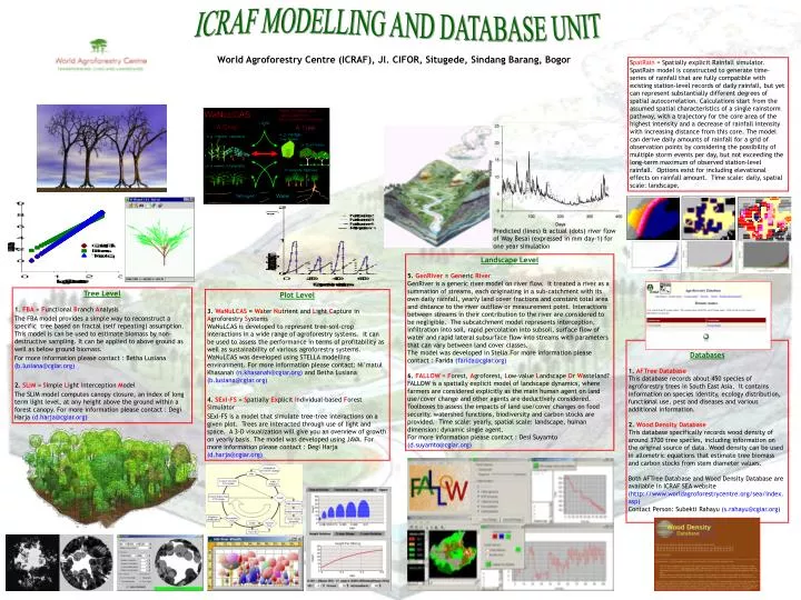
Predicted (lines) & actual (dots) river flow of Way Besai (expressed in mm day-1) for one year simulation. ICRAF MODELLING AND DATABASE UNIT. World Agroforestry Centre (ICRAF), Jl. CIFOR, Situgede, Sindang Barang, Bogor.

E N D
Predicted (lines) & actual (dots) river flow of Way Besai (expressed in mm day-1) for one year simulation ICRAF MODELLING AND DATABASE UNIT World Agroforestry Centre (ICRAF), Jl. CIFOR, Situgede, Sindang Barang, Bogor SpatRain = Spatially explicit Rainfall simulator. SpatRain model is constructed to generate time-series of rainfall that are fully compatible with existing station-level records of daily rainfall, but yet can represent substantially different degrees of spatial autocorrelation. Calculations start from the assumed spatial characteristics of a single rainstorm pathway, with a trajectory for the core area of the highest intensity and a decrease of rainfall intensity with increasing distance from this core. The model can derive daily amounts of rainfall for a grid of observation points by considering the possibility of multiple storm events per day, but not exceeding the long-term maximum of observed station-level rainfall. Options exist for including elevational effects on rainfall amount. Time scale: daily, spatial scale: landscape. Landscape Level 5. GenRiver = GenericRiver GenRiver is a generic river model on river flow. It treated a river as a summation of streams, each originating in a sub-catchment with its own daily rainfall, yearly land cover fractions and constant total area and distance to the river outflow or measurement point. Interactions between streams in their contribution to the river are considered to be negligible. The subcatchment model represents interception, infiltration into soil, rapid percolation into subsoil, surface flow of water and rapid lateral subsurface flow into streams with parameters that can vary between land cover classes. The model was developed in Stella.For more information please contact : Farida (farida@cgiar.org) 6. FALLOW = Forest, Agroforest, Low-value Landscape Or Wasteland? FALLOW is a spatially explicit model of landscape dynamics, where farmers are considered explicitly as the main human agent on land use/cover change and other agents are deductively considered. Toolboxes to assess the impacts of land use/cover changes on food security, watershed functions, biodiversity and carbon stocks are provided. Time scale: yearly, spatial scale: landscape, human dimension: dynamic single agent. For more information please contact : Desi Suyamto (d.suyamto@cgiar.org) Tree Level 1. FBA = Functional Branch Analysis The FBA model provides a simple way to reconstruct a specific tree based on fractal (self repeating) assumption. This model is can be used to estimate biomass by non-destructive sampling. It can be applied to above ground as well as below ground biomass. For more information please contact : Betha Lusiana (b.lusiana@cgiar.org) 2. SLIM = Simple Light Interception Model The SLIM model computes canopy closure, an index of long term light level, at any height above the ground within a forest canopy. For more information please contact : Degi Harja (d.harja@cgiar.org) Plot Level 3. WaNuLCAS = Water Nutrient and Light Capture in Agroforestry Systems WaNuLCAS is developed to represent tree-soil-crop interactions in a wide range of agroforestry systems. It can be used to assess the performance in terms of profitability as well as sustainability of various agroforestry systems. WaNuLCAS was developed using STELLA modelling environment. For more information please contact: Ni’matul Khasanah (n.khasanah@cgiar.org) and Betha Lusiana (b.lusiana@cgiar.org) 4. SExI-FS = Spatially Explicit Individual-based Forest Simulator SExI-FS is a model that simulate tree-tree interactions on a given plot. Trees are interacted through use of light and space. A 3-D visualization will give you an overview of growth on yearly basis. The model was developed using JAVA. For more information please contact : Degi Harja(d.harja@cgiar.org) Databases 1. AFTree Database This database records about 450 species of agroforestry trees in South East Asia. It contains information on species identity, ecology distribution, functional use, pest and diseases and various additional information. 2. Wood Density Database This database specifically records wood density of around 3700 tree species, including information on the original source of data. Wood density can be used in allometric equations that estimate tree biomass and carbon stocks from stem diameter values. Both AFTree Database and Wood Density Database are available in ICRAF SEA website (http://www.worldagroforestrycentre.org/sea/index.asp) Contact Person: Subekti Rahayu (s.rahayu@cgiar.org)