Download

1 / 16
160 likes | 338 Views
Introduction to Geographic Information Systems (GIS). Organization of presentation. Basics of GIS GIS data at the New Jersey Department of Environmental Protection. Basics of GIS. Geographic Information Systems (GIS). GIS facilitates visualization and analysis of spatial data

E N D
Organization of presentation • Basics of GIS • GIS data at the New Jersey Department of Environmental Protection
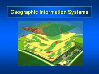
Geographic Information Systems (GIS) • GIS facilitates visualization and analysis of spatial data • Spatial data are stored in map layers
Coordinate Systems • Spatial data are referenced to locations on the earth’s surface using coordinate systems • Ensure all map layers share a common coordinate system • Recognized global coordinate systems consist of: • A Spheriod: a mathematical description of the earth’s shape • A Map Projection: a mathematical conversion from spherical to planar coordinates
Scale • Tells how map distance relates to real world distance • Map Scale: ratio of map distance to actual ground distance • 1:10,000 (1 map cm = 10,000 real cm) • Small scale (1:100) vs. large scale (1:10) • Scale Bar: graphic display of map scale
Resolution • The accuracy with which a given map scale can depict the location and shape of map features • Larger the map scale, the higher the resolution • As map scale decreases, resolution diminishes and feature boundaries are smoothed, simplified, or not shown at all. • Rule of thumb: error = 2% of map scale • Resolution plays a large role in GIS, especially in raster-based modeling
Raster-based GIS • Data stored in a ‘regularized grid of cells covering an area’ • Grid cells called picture elements or ‘pixels’ • Nodes, Arcs, Areas
Vector-based GIS • Image and data stored separately • Data: attribute table • Image: points, lines, polygons
Summary • GIS facilitates visualization and analysis of spatial data • Spatial data are stored in map layers • Most GIS programs are raster- or vector- based • Raster - data and image stored together in regularized grid made of pixels • Vector - data and image stored separately; points, lines and polygons
GIS and Water Quality data at the New Jersey Department of Environmental Protection http://www.nj.gov/dep/
NJDEP - GIS The NJDEP – GIS Department (http://www.nj.gov/dep/gis/) provides GIS files for state administrative areas, hydrology, geology, land use, etc., such as: • Counties • Digital Elevation Grid • Hydrography • Watersheds • Water Quality Monitoring Stations
NJDEP - Water Monitoring & Standards The NJDEP Office of Water Monitoring & Standards (http://www.state.nj.us/dep/wmm/) oversees the Bureau of Fresh Water and Biological Monitoring . This bureau is in charge of monitoring the ambient conditions of the state's fresh and ground water resources. This monitoring includes : • regular sampling through a statewide network consisting of 115 surface water monitoring stations, • 820 benthic macroinvertebrate biological stream monitoring stations, • 100 fish assemblage biological stream monitoring stations, and • 150 ground water stations.
ESRI arcGIS at UNC UNC GIS software includes ESRI arcGIS version 9.0, 9.1 , 9.2 , 9.3 Getting Started: http://www.lib.unc.edu/reference/gis/getting_started.html Technical support research@unc.edu (919) 962-HELP Data Sources: http://www.lib.unc.edu/reference/gis/ Amanda C. Henley, GIS Librarian amanda.henley@unc.edu (919) 962-1151