Download

1 / 65
700 likes | 1.21k Views
Paleo- Geology of the Middle East. Middle East Jurassic and development of known oilfields Paleo- Geology of KSA Cratonic development of the Middle East.

E N D
Paleo- Geology of the Middle East • Middle East Jurassic and development of known oilfields • Paleo- Geology of KSA • Cratonic development of the Middle East
All the oil fields of Saudi Arabia are of the structural type and they all lie in the northeastern part of the country, including the Saudi offshore portion of the Persian Gulf. These oil field structures are mostly produced by extensional block faulting in the crystalline Precambrian basement along the predominantly N-S Arabian Trend which constitutes the 'old grain' of Arabia. This type of basement horst, which has been periodically reactivated, underlies the world's largest oil field, Ghawar, and other major oil fields, such as Khurais, Mazalij and Abu Jifan. The basement horst beneath Ghawar Anticline has been suggested by Aramco (1959), from a positive Bouguer gravity anomaly which practically mirrors the field, and more recently, in greater detail, by Barnes (1987). All Saudi Arabian offshore oil fields, and some near coastal fields, such as Abu Hadriya, Abqaiq and Dammam, are also produced by basement faulting which has cut the saliferous, Upper Precambrian Hormuz Series, triggering deep-seated salt diapirism. Consequently, Saudi Arabian offshore and coastal fields are denoted by distinctive negative gravity anomalies. Some of these oil fields are circular, such as Dammam, Abu Hadriyah and Karan, whereas others are elongated, due to salt wall diapirism, as in the case of Khafji, Kurayn, Jana and Jurayd. The latter oil fields all follow a NE to NNE trend believed to be due to left-lateral strike-slip faulting in the basement, as seen in Kuh-e Namak on the Iranian side of the Gulf. One large offshore oil field at Manifa trends NW-SE, paralleling the Persian Gulf and is due to right-lateral strike-slip faulting in the basement along the well-known Erythraean Trend (von Wissman et alii 1942). An undeveloped offshore oil field at Hasbah trends E-W, due to basement faulting in this direction. Some major, elongated offshore oil fields with negative gravity anomalies trend almost N-S along the Arabian Trend, including Berri and Qatif, as well as the nearby Bahrain and Dukhan fields. All the known oil fields of Saudi Arabia and its offshore are thus related to four major directions of basement faulting, namely N-S, NE-SW, NW-SE and E-W. The major fault trend is the N-S Arabian Trend, which has produced repeated basement horsts and grabens due to extensional tectonics. In the Saudi offshore portion of the Persian Gulf, NE-SW, left-lateral strike-slip faulting of the basement is also important in forming oil-field structures. A major difference between Saudi Arabian onshore and offshore oil fields is that the former show strong positive gravity anomalies due to block uplift of basement, whereas the latter have pronounced negative anomalies due to deep-seated salt diapirism induced by faulting in the crystalline basement. Detailed analysis of the potential field of gravity in the oil-field areas of Saudi Arabia, both offshore and onshore, substantiates these major basement-fault directions and shows the marked coincidence of oil-field outlines with large basement-induced gravity anomalies. The regmatic shear pattern of basement faulting is also clearly shown by mapping the second derivative of the potential field of gravity. BASEMENT TECTONICS OF KSA AS RELATED TO OILFIELD STRUCTURAL DEVELOPMENT
Anticlinal or domal structures in the sedimentary sequence of the northeastern Arabian Platform and its offshore extension, contain all the known oil and gas fields of Saudi Arabia (ministry of Petroleum 1984). These currently comprise some fifty six oil fields and four gas fields (Fig. 1), all of which owe their origin to deep-seated tectonic movements in the Precambrian crystalline basement (Edgel 1987). The thickness of the sedimentary sequence varies from 4,500m to 13,700m by gradual thickening towards the northeast.
Underlying the (above) sediments in most of onshore northeastern Saudi Arabia, there is a faulted Precambrian basement, with alternating horsts and grabens directed along the N-S Arabian Trend. This is the 'old grain' of the Arabian Peninsula formed by repeated, E-W, extensional tectonism (Henson 1951). As a result, almost all the onshore oil fields of northeastern Saudi Arabia exhibit distinctive positive gravity anomalies due to the presence of denser uplifted basement beneath them. As in the case of Ghawar, the world's largest oil field, the presence of an underlying, N-S directed, horst block was first suggested by Aramco (1959). Further refined computerized study of the potential field of gravity, including running difference gravity (Barnes 1987), shows a gravity high almost exactly underlying Ghawar Oil Field. Study of the second derivative of the potential field of gravity shows the location at depth of basement faults bordering this underlying horst, as well as some oblique, cross-cutting faults, which are apparently left-lateral, strike-slip faults in the basement. Many other oil fields to the west and south of Ghawar also show a striking coincidence of positive gravity anomalies with their known extent, as in the cases of Mazalij, Abu Jifan, Tinat, Khurais, Bakr and Faridah (Barnes 1987). They are all underlain by uplifted basement blocks and their crestal stratigraphic sequences indicate repeated rejuvenation of their underlying basement uplifts. In offshore northeastern Saudi Arabia and adjacent coastal areas, more than 20 oil fields occur, all marked by distinctive negative gravity anomalies (Edgell 1987). This is because basement faulting has also penetrated the Upper Precambrian halite beds of the Hormuz Series, thus triggering deep-seated salt diapirism and producing domal oil-field structures. Some of these oil fields, such as Karan, Abu Sa'afah, Abu Hadriyah and Dammam, have the typical circular shape of diapiric oil structures. Most offshore oil-field structures are elongated, doubly plunging anticlines, such as Safaniyah, Khafji, Kurayn, Jana and Jurayd. They are elongated along a general NE to NNE direction (Aualitic Trend of von Wissmann et alii 1942) and are due to left-lateral, strike-slip faulting in the basement, which has also penetrated the salt beds of the Hormuz Series causing diapiric salt-wall structures at depth (Player 1969), which have uplifted the overlying strata in elongated anticlines. Uplift of an elongated oil-field structure, in the Manifa Field, parallels the coast of northeastern Saudi Arabia and also exhibits a strong negative gravity anomaly. It is interpreted as originating from basement faulting along a NW trend (the Erythraean Trend of von Wissmann et alii, 1942) which has also cut the Upper Precambrian salt beds of the Hormuz Series, allowing the lighter salt to move upwards as a broad salt wall, thus pushing up overlying Phanerozoic strata into a NW-SE elongated, doubly plunging, anticline. Only one, undeveloped, oil field at Hasbah/Farsi (Mina et alii 1967), near the Saudi/Iranian offshore border, is clearly developed along an E-W structural alignment (i.e. the Tethyan Trend, Henson 1951). This is the Hasbah structure, which is also an elongated doubly plunging anticline with a negative gravity anomaly (Player 1969), due to basement faulting and rupture of the Hormuz Series salt beds, causing deep-seated diapirism and consequent structural growth. A close examination of the gravity pattern, especially of the second derivative of the potential field of gravity, shows quite a number of basement elements aligned along the Tethyan Trend. Four trends of basement faulting control the oil fields of Saudi Arabia (Henson 1951), most prominently the N-S Arabian Trend, as well as the N-E Aualitic Trend and the N-W Erythraean Trend in offshore diapiric fields. Least conspicuous is the E-W Tethyan Trend.
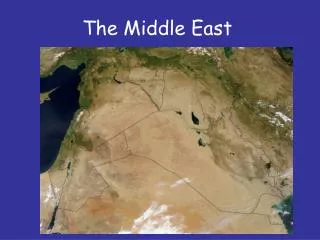
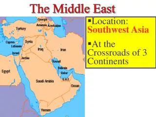
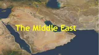
Geological Background The oil-field areas of Saudi Arabia are all located in the northeast part of the Kingdom, both onshore and offshore, in a tectonostratigraphic province referred to as the Arabian Platform, or Unstable Shelf (Henson 1951). It is composed of a sedimentary sequence, which is virtually subhorizontal, except for a few basement-induced and diapiric folds (Greig 1958), comprising the Arabian Platform, and thickening northeast from 4,500m to 13,700m. To the southwest of the Arabian Platform, the NE-dipping, scarp-forming, Mesozoic and Paleozoic strata form the Interior Homocline, which rests nonconformably on the northeast edge of the Arabian Shield. Crystalline Precambrian igneous and metamorphic rocks, similar to those exposed in the Arabian Shield, underlie both the Interior Homocline and the Arabian Platform, where a few deep wells have cored crystalline basement. Figure 2
Plate Tectonic Setting of Arabia. On the northeast side of the Persian Gulf, and especially in southern Iran and northeast Iraq, the Zagros Fold Belt (Falcon 1967, 1969), with row upon row of NE-SE trending anticlines forms a separate tectonostratigraphic province, to the northeast of the Arabian Platform. The Main Zagros Reverse Fault (Berberian 1976, 1981), sometimes called the Zagros Thrust, limits the Zagros Fold Belt along its northeast side and separates it from the Iranian Plate. All these tectonic units (Fig. 2), from the opening Red Sea, across the Arabian Shield to the Interior Homocline, Arabian Platform, Zagros Fold Belt, Zagros Thrust, Iranian Plate, Convergence Zone, and Eurasian Plate, form part of a dynamic, plate tectonic system (Jackson et alii 1981). The separation of the Arabian Plate from Africa along the Red Sea, which is widening at 1.2 cm per year in a NNE direction (NASA personal communication), has propelled the Arabian Plate towards Iran, buckling, folding and faulting the Zagros Ranges until their sediments are subducted beneath the Iranian Plate along the Main Zagros Reverse Fault. There is every evidence that the Arabian Plate extends beneath southern Iran, as pointed out by Falcon (1967), Morris (1977) and Jackson et alii (1981). Within the Arabian Platform (Fig. 3) there are very few fold structures paralleling the Zagros Fold Belt, although both structural zones are subparallel and elongated in a NW-SE direction. The few weak folds of the Iranides are seen in an indistinct ridge, joining Dammam-Bahrain and northern Qatar, and in some NW-SE folds in the Gulf of Bahrain and at Al 'Uqayr (Kassler 1973). Another NW-SE trending anticlinal fold along the northeastern coast of Saudi Arabia forms the Manifa Oil Field. However, the major fold structures in the Arabian Platform trend almost N-S along the Arabian Trend and are due to extensional faulting of the crystalline Precambrian basement, giving rise to an alternating system of horsts and grabens (Edgell 1987), which have pushed up overlying Phanerozoic strata. This has produced major elongated, doubly plunging, anticlinal oil fields, such as Ghawar (140 km long), Khurais Oil Field (75 km long), Qatif Oil Field (55 km long), and numerous other, N-S directed, oil fields of basement origin, such as Abu Jifan, Mazalij, Harmaliyah, Bakr, Juraybi'at, Wari'ah, El Haba, Faridah, Rimthan, Dibdibah, and Jaham. The recently discovered Permo-Carboniferous sand-reservoir fields at Al Hawtah, Dilam, Hilwah, Ragibh and Nu'ayyim also lie along the Arabian Trend, and form an exception in that they lie within the Interior Homocline, where Jurassic and Cretaceous strata are exposed. Outcrops in the Arabian Platform, on the other hand, are predominantly Upper Tertiary (Neogene) with minor areas of Lower Tertiary strata (U.S. Geological Survey 1963). Figure 3
In coastal parts of northeastern Saudi Arabia, and in the Saudi offshore portion of the Gulf, different structural trends and structural types exist, but are all basement related. A NE to NNE trend is clearly seen in major offshore oil field structures, such as Safaniya, Khafji, Marjan, Kurayn, Jana and Jurayd, as well as onshore in oil fields, such as Abqaiq and Khursaniyah. These fields are all related to faulting of the basement along a NE trend as seen in Kuh-e Namak (Talbot and Jarvis 1984). The underlying basement faults are considered to be left-lateral, strike-slip faults, which have also cut the thick saliferous Precambrian Hormuz Series providing release for the lighter halite. As a consequence, deep-seated diapirism of the salt-wall type has pushed up overlying Phanerozoic strata producing elongated doubly plunging anticlines in the Saudi offshore and coast and forming major oil fields. In some cases, intersecting NE and NW basement faults have provided a focal point for salt diapirism and typical circular salt domes have been formed, as at Abu Hadriyah, Abu Sa'afah, Karan and Dammam. Salt diapirism is also associated with some of the trends of oil-field structures, where deep-seated diapirism has been caused by basement faults. These include the old N-S Arabian Trend, as seen in the Berri Oil Field, the NW-SE Erythraen Trend as seen in the Manifa Oil Field, and the E W Tethyan Trend as seen in the undeveloped Hasbah Oil Field. Surface strata are mainly subhorizontal in the oil-field areas of northeastern Saudi Arabia, with only very gentle dips (less than 1°) on the flanks of anticlines. However, structural closure increases with depth in the Saudi oil field anticlines by two methods. Firstly, repeated rejuvenation of the major onshore fields has occurred by repeated intervals of basement uplift. These fields are marked by thinning, or truncation, over the fold axis, accompanied by a number of unconformities (Edgell 1987). The oil-field structures of coastal and offshore Saudi Arabia represent a second type and exhibit gradual growth as the deep-seated salt diapirs have slowly pushed up overlying strata. These diapiric structures are usually due to salt growth from Mid-Cretaceous to Recent and, in some cases, have started growth as far back as Late Jurassic. They originate from basement faults cutting the salt beds of the Hormuz Series, which are up to 2 km thick in the Gulf (Rönnlund and Koyi 1988; Player 1969). Intersecting basement faults may produce typical, circular, salt-dome structures, whereas single faults allow salt-wall diapirism to dome up more elongated structures. In general, oil fields with a deep-seated salt diapiric origin are either domes, such as Dammam, Abu Hadriyah, and Khursaniyah, or brachyanticlines, such as Berri, Manifa, Jana and Kurayn.
Nature of Basement in Northeastern Saudi Arabia The evidence for the type of rocks forming the Precambrian basement under the sedimentary cover in the oil-field areas of northeastern Saudi Arabia is only direct in a few instances. This applies in the case of some deep wells which have been drilled to basement as at Jaham No.2, El Haba No.2, Haradh No.51, Abu Jifan No.23, Al Hawtah No.1, Ain Dar No.196 and Qirdi No.5. All these wells have encountered crystalline igneous or metamorphic rocks, similar to those found in the Arabian Shield. As can be extrapolated, these Upper Precambrian crystalline rocks dip beneath the sediments of the Interior Homocline and the Arabian Platform, so that they are found at depths of from 4,500 m to 13,700 m in the Saudi oil-field areas. Much of the evidence regarding depth to basement has been deduced from geophysical surveys, primarily gravity and magnetic investigations. In the case of the newly discovered oil fields at Al Hawtah, Dilam, Raghib and Nu'ayyim, there is also direct seismic evidence of the depth to basement.
GHAWAR OILFIELD The Ghawar Oil Field is by far the largest conventional oil field in the world and accounts for more than half of the cumulative oil production of Saudi Arabia. Although it is a single field, it is divided into six areas. From north to south, they are Fazran, Ain Dar, Shedgum, Uthmaniyah, Haradh and Hawiyah. Although Arab-C, Hanifa and Fadhili reservoirs are also present in parts of the field, the Arab-D reservoir accounts for nearly all of the reserves and production.
Ghawar Field, Ain Dar Area, Arab-D Reservoir Parameters, Saudi Aramco (1980) Ghawar Field, Ain Dar Area, Arab-D Reservoir Parameters, Saudi Aramco (1980)
Ghawar Field, Shedgum Area, Arab-D Reservoir Parameters, Saudi Aramco (1980) Ghawar Field, Shedgum Area, Arab-D Reservoir Parameters, Saudi Aramco (1980)
Ghawar Field, Uthmaniyah Area, Arab-D Reservoir Parameters, Saudi Aramco (1980) Ghawar Field, Uthmaniyah Area, Arab-D Reservoir Parameters, Saudi Aramco (1980)
Ghawar Field, Hawiyah Area, Arab-D Reservoir Parameters, Saudi Aramco (1980) Ghawar Field, Hawiyah Area, Arab-D Reservoir Parameters, Saudi Aramco (1980)
Ghawar Field, Haradh Area, Arab-D Reservoir Parameters, Saudi Aramco (1980) Ghawar Field, Haradh Area, Arab-D Reservoir Parameters, Saudi Aramco (1980) Ghawar Field, Haradh Area, Arab-D Reservoir Parameters, Saudi Aramco (1980)
GEOLOGY OF THE GHAWAR OILFIELD: KSA The Ghawar structure consists of two subparallel, north-south trending structural crests, separated by a saddle. It is about 174 miles long and 12 miles wide. In the northern part of the field, the saddle dips below the initial oil-water contact between Uthmaniya and Ain Dar, but the two crests remain above it. The Fazran and Ain Dar areas are along the western crest and the Shedgum area is along the eastern crest. The three southern areas extend across both crests. These crests existed at the time of Arab-D deposition and the reservoir quality is best in the crestal areas. A map of the Ghawar structure at Arab-D level appears below. The oil-water contact at Ghawar dips to the northeast, dipping more than 660 feet between the southwest end of Haradh and the Fazran area. The contact is consistently higher on the west flank of the field than on the east, and a tar mat is associated with the original contact. Water injection wells are completed above this tar mat for pressure maintenance. This peripheral waterflood project began in the early sixties in the northern parts of the field. By the time that the southern Hawiyah and Haradh areas were developed during 1994 to 1996, horizontal-drilling technology was available. Horizontal injectors were completed above the tar mat to provide line source distribution of water along the periphery of the field.
GHAWAR GEOLOGY (CONTINUED) The anhydrite in the Upper Arab-D forms the seal for the 1,300-foot oil column in Ghawar. It is composed of sabkha evaporites and subaqueous evaporites with thin carbonate interbeds that can be traced for hundreds of kilometers. The anhydrite thickens to the south at the expense of the reservoir zones; the combined thickness remains relatively constant. The Arab-D reservoir at Ghawar comprises two major shoaling-upward cycles deposited during a relative highstand in sea level (Mitchell et al, 1988). It is composed of skeletal grainstones and packstones with ooid grainstones locally common in the upper Arab-D. The diagenetic processes that have affected the Arab-D reservoir include dolomitization, leaching and recrystallization, cementation, compaction and fracturing. Interparticle porosity is abundant in the Arab-D reservoir in the Ghawar Field and moldic porosity is common as well. Intercrystal pores are common in dolomites and microporosity is abundant in both limestone and dolomite lithologies. In the uppermost part of the Arab-D are occasional zones that contain more than 10% of a stromatoporoid sponge known as cladocoropsis. Where this facies is dolomitized, the relatively fine-grained matrix is replaced by dolomite and the cladocoropsis is leached, causing a phenomenon described by reservoir engineers as super-permeability. These super-permeable zones, where present, offer so little resistance to fluid flow as to be difficult to model for reservoir engineering purposes.
GHAWAR GEOLOGY (CONTINUED) The Ghawar structure consists of two subparallel, north-south trending structural crests, separated by a saddle. It is about 174 miles long and 12 miles wide. In the northern part of the field, the saddle dips below the initial oil-water contact between Uthmaniya and Ain Dar, but the two crests remain above it. The Fazran and Ain Dar areas are along the western crest and the Shedgum area is along the eastern crest. The three southern areas extend across both crests. These crests existed at the time of Arab-D deposition and the reservoir quality is best in the crestal areas. A map of the Ghawar structure at Arab-D level appears below. The oil-water contact at Ghawar dips to the northeast, dipping more than 660 feet between the southwest end of Haradh and the Fazran area. The contact is consistently higher on the west flank of the field than on the east, and a tar mat is associated with the original contact. Water injection wells are completed above this tar mat for pressure maintenance. This peripheral waterflood project began in the early sixties in the northern parts of the field. By the time that the southern Hawiyah and Haradh areas were developed during 1994 to 1996, horizontal-drilling technology was available. Horizontal injectors were completed above the tar mat to provide line source distribution of water along the periphery of the field.
GHAWAR OILFIELD: PRODUCTION HISTORY The Ghawar Field was discovered in 1948. Production began in 1951 and reached a peak of 5.7 million barrels per day in 1981. This is the highest sustained oil production rate achieved by any single oil field in world history. At the time that this record was achieved, the southern areas of Hawiyah and Haradh had not yet been fully developed. Production was restrained after 1981 for market reasons, but Ghawar remained the most important oil field in the world. The production of the Samotlor Field in Russia was greater during the mid-eighties, but this was because production at Ghawar was restrained. Development of the southern Hawiyah and Haradh areas during 1994 to 1996 allowed production from the Ghawar Field to exceed 5 million barrels per day once again, more than Samotlor ever produced. This remarkable production history is because of the enormous size of the Arab-D reservoir in the Ghawar Field. Alsharhan and Kendall (1986, Table 1) provide a figure of 693,000 acres for the productive area of the Ghawar Field. This represents a single, pressure-continuous reservoir. Cumulative production by yearend 2000 was about 51 billion barrels of oil.
SAUDI ARABIA • PRECAMBRAIN GEOLOGY • EARLY TECTONICS
POTENTIAL SOURCE ROCKS FOR THE GAS AND OIL COMPONENTS OF THE GHAWAR FIELD CAMBRIAN ARGILLACEOUS ‘REEFS’ AND SHALES AND DEVONIAN AND LOWER CARBONATE REEFS
The Prevailing Geological Theory as to the source rock for the Ghawar oil is that it is believed to be the: “Tuwaiq Mountain Formation, which underlies the Hanifa. It is Callovian and Oxfordian in age and reaches a thickness of more than 300 feet in the basinal area between the Ghawar and Khurais Fields. That this moderate volume of source rock should produce the largest accumulation of light oil in the world indicates very efficient migration and entrapment. The fact that the Ghawar oil-water contact is substantially higher on the west flank than on the east indicates a hydrodynamic gradient to the east, which may explain the much larger volume of oil in Ghawar than in Khurais.” However this fails to account for the differences in the oil between the two fields (and all other major fields) and is highly unlikely to be the sole source of oil for either of these giants. It is much more likely that these is a series of petroleum formation systems at work, since each major field is different in type of chemical mix of trace elements, kind, quality and content of the oil. From research done to date by the CEC team, it appears likely that there are at least 5 petroleum systems at work in generating each field’s chemical mix of oil and gas. As the oil and gas source rocks leak into upper traps they mix with existing chemicals and form a new mixed chemical “source” of oil and gas which leaks during further fault movement into upper traps becoming again mixed with existing chemicals and forming a new “source” for future upward or sideways leaking. CEC’s Team are specialists in doing tracer analysis to determine the source of oil and gas and to determine best ways of drilling and producing from the deeper traps
Geochemical variations among eastern Saudi Arabian paleozoic condensates related to different source kitchen areas Large reserves of gas and condensate are found in Paleozoic reservoirs (Khuff, Unayzah and Jauf) in the Ghawar area of eastern Saudi Arabia. The source rock for these hydrocarbons is the basal organic-rich “hot shale” of the Qusaiba member of the Silurian Qalibah Formation. This is the same prolific source rock that generated the sweet light crude oil and condensate found in the Unayzah reservoirs in central Saudi Arabia. Thermal maturity modeling of the source rock identifies two kitchen areas: to the east and west of the Ghawar structure. The west kitchen was well into the oil window by 210 Ma, while the east kitchen was just entering the oil window. Large areas of both kitchens were in the wet gas window by 125 Ma and by 90 Ma most of the area north of Ghawar was generating dry gas. In eastern Saudi Arabia, Paleozoic oil and condensate are found in early-formed structures (Carboniferous and early Triassic growth), whereas late Cretaceous and Tertiary structures contain only dry gas. The geochemistry of the oils and condensates indicates two groups, each generated from a different hydrocarbon kitchen, suggesting that the two kitchens differ slightly in organic facies. Within each group, variations among hydrocarbons are related to the thermal maturity of the source rock during generation. Within the Khuff reservoir, gas souring is caused by thermochemical sulfate reduction.
DRILLING AND PRODUCING THE PETROLEUM SOURCE ROCKS • ON THE UNSTABLE PLATFORM THE SOURCE ROCKS ARE SEVERLY DOWNTHRUST TO THE EAST AND NORTH. DEPTHS INCREASE DRAMATICALLY TO THE NORTH AND EAST OF GHAWAR TO 13,700 M! • INTERMEDIATE TRAPS IN ARGILLACEOS REEFS AND CORAL BASED REEFS (LIMESTONE AND DOLOMITE) ARE ALSO EXPECTED ABOVE THE DEEP HOT SHALES • EACH OIL AND GAS TRAP CAN NOW BE ACCESSED BY MODERN DRILLING AND COMPLETION PRACTICES. EVEN THE HOT SHALES ARE BEING PRODUCED IN CANADA USING NEW TECHNOLOGIES. • VERY DEEP RESERVOIRS IN THE PERSIAN GULF CAN BE FOUND AND DEVELOPED ALSO USING NEW TECHNOLOGIES
THE BP ANNOUNCEMENT IN OCTOBER, 2009 OF A TERTIARY ROCK LIGHT OIL DISCOVERY AT 30,000 + FEET DEPTH IN THE GULF OF MEXICO CONFIRMS OUR GEOLOGIC TREATISE THAT LIGHT OIL EXISTS VERY DEEP WITHOUT HAVING BEEN DESTROYED IN DOWNTHRUSTING TECTONIC ACTIVITY OR BY MEANS OF IMPACT IN THIS CASE BY A COMET 77 MILLION YEARS AGO. AT THE TIME OF IMPACT THE CURRENT RESERVOIR WAS AT OR VERY NEAR SURFACE. BASLTIC LAYERS AND SALT INCURSIONS FORM THE SEAL ON OIL LIKELY SOURCED FROM AN EVEN DEEPER DOLOTOMIZED REEF (SOURCE ROCK IN AN ARGILLACEOUS LIMESTONE OR SHALE WOULD HAVE BEEN COMPRESSED AND THE RESULTANT HEAT AND PRESSURE COOK THE OIL INTO GAS). EVEN MORE INTERESTING IS THAT BP WAS ABLE TO IMAGE THE TRAP BELOW BOTH SALT AND BASALT! OUR TEAM USES MANY TECHNOLOGIES INCLUDING THESE TYPES TO FIND DEEPER SOURCE RESERVOIRS!