Download
1 / 2
20 likes | 119 Views
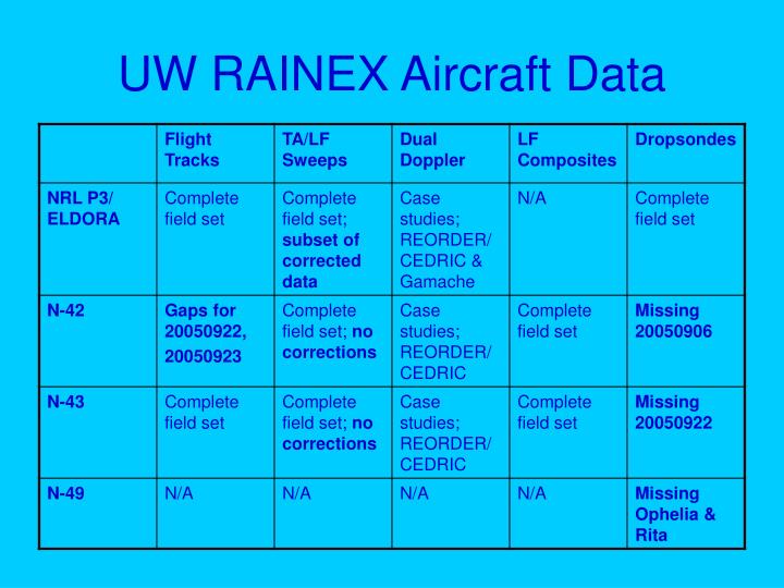
UW RAINEX Aircraft Data. UW RAINEX Data Set. Satellite – GOES; 1km & 4km netcdf format Ground radars – netcdf format NEXRAD composites Model – netcdf; alt: 0.03-18.6 km; lat:10 to 39.2 deg; lon: -95 to -45.2 deg

E N D
UW RAINEX Data Set • Satellite – GOES; 1km & 4km netcdf format • Ground radars – netcdf format • NEXRAD composites • Model – netcdf; alt: 0.03-18.6 km; lat:10 to 39.2 deg; lon: -95 to -45.2 deg • Between storms – analysis (1 time); forecast (8 times, 3hrly); RHL, RHI, RAINR_INST, SLP, TPRESSURE, U, V, W, TSEASFC • MM5_CMC • MM5_GFDL • MM5_GFS • MM5_NOGAPS • Periods of interest – analysis (1 time); forecast (8 times; 3hrly); RAINR_INST,CARTVRVTAN,CARTVRVRAD,U,V,WSPD,T,Q,QTOTAL,CLW,RNW,ICE,SNOW,GRAUPEL,W,THETAE,RHL,RHI,POTTEMP,PVORT,MPVORT,TPRESSURE,DBZ,TV,SLP,GHT,GHTW,ZAVORT, ZRVORT,XAVORT,XRVORT,YAVORT,YRVORT • MM5_CMC • MM5_GFDL