Download
1 / 18
180 likes | 271 Views
Moist sounding last night, and this morning, so clearly in “tropical” regime. Cold point about -85 (188K, below static equivalent of structure limit). Satellite image has very deep convective systems in our area. There have been some lightning

E N D
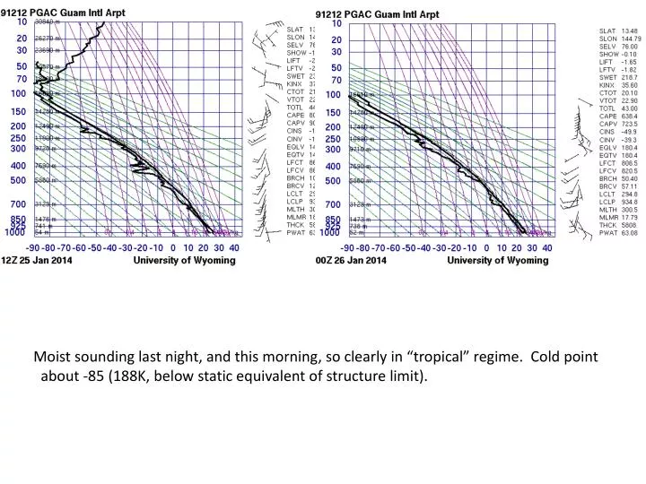
Moist sounding last night, and this morning, so clearly in “tropical” regime. Cold point about -85 (188K, below static equivalent of structure limit).
Satellite image has very deep convective systems in our area. There have been some lightning returns in the past 12 hours from systems along the front.
Cloud tops in SPCZ (red) are clearly reaching the Cold Point Tropopause.
Situation now, model does show sig rain in past six hours. Low placed too far to SW compared to ASCAT.
Tomorrow, moves low south of Guam. How far south governs the wind direction. Still unstable tropical air.
Moist in a deep layer still (28kft, above fr level), with convective showers in our vicinity.
NCAR model is more optimistic on the winds.. But not on the rain, unless you believe hi res. Run to run consistency on the high res has not been that good, so I wouldn’t hang your hat on these details (that look good for tomorrow’s takeoff). I think we made good decision not to try for tomorrow.
Low moves west, probability of tail winds near zero, cross winds within limits. Still rain in the vicinity.
Landing winds are 15, 110, NCAR model more easterly. This will need to be watched. Still moist in deep layer in the vicinity (not shown)
landing takeoff NCAR model concurs on rain in the vicinity on TO. Winds (not shown) have similar prog to GFS on TO (but more optimistic, less cross wind). NCAR model more optimistic on landing also (winds from NE). Precip structure (details) on Tuesday landing are different than GFS, but we still have rain and convection in the vicinity. Landing.
Convection in region on Tuesday focused on SPCZ and region to our north and west (associated with low). Flight track will go down to 160E, 5S, where convection is potentially deep.
Low on its way out, to be replaced by trade wind regime (Wednesday). Still a fair amount of moisture at high levels attm. GFS still forecasts a slight southerly component, but still within limits.