Download
1 / 123
1.28k likes | 1.54k Views
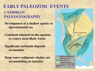
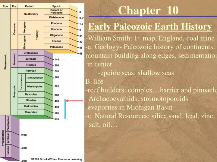
Chapter 10. Early Paleozoic Earth History. -William Smith: 1 st map, England, coal mine -a. Geology- Paleozoic history of continents: mountain building along edges, sedimentation in center -epeiric seas: shallow seas B. life -reef builders: complex…barrier and pinnacle

E N D
Chapter 10 Early Paleozoic Earth History -William Smith: 1st map, England, coal mine -a. Geology- Paleozoic history of continents: mountain building along edges, sedimentation in center -epeiric seas: shallow seas B. life -reef builders: complex…barrier and pinnacle Archaeocyathids, stromotoporoids -evaporites in Michigan Basin -c. Natural Resources: silica sand, lead, zinc, salt, oil…
Fuel for the Industrial Revolution Revolutionized Geology • The Carboniferous coal beds of England • helped fuel the Industrial Revolution, • during the late 1700s and early 1800s • William Smith, first began noticing • how rocks and fossils repeated themselves • in a predictable fashion while mapping various coal mines • Smith surveyed the English countryside • for the most efficient canal routes • to bring the coal to market
The First Geologic Map • Measuring more than eight feet high and six feet wide, • Smith's hand-painted geologic map of England • represented more than 20 years • of detailed study of the rocks and fossils of England • England is a country rich in geologic history • Five of the six geologic systems • were described and named • for rocks exposed in England • Cambrian, Ordovician, Silurian, Devonian, and Carboniferous
The First Geologic Map • William Smith, • a canal builder, published the first geologic map • on August 1, 1815
Understanding Geology Gave Smith an Advantage • Much of his success was based on the fact • he was able to predict what rocks • canal diggers would encounter • His observations of the geologic history • of England allowed William Smith • to make the first geologic map of an entire county! • We will use the same basic geologic principles • William Smith used to interpret the geology • of the Paleozoic Era
Paleozoic History • The Paleozoic history of most continents • involves major mountain-building activity along their margins • typically shallow-water marine sediments • transgressions and regressions over their interiors • These transgressions and regressions • were caused by global changes in sea level(eustatic) • that most probably were related • to plate activity and glaciation
Paleogeography of the World • For the Late Cambrian Period
Paleogeography of the World • For the Late Ordovician Period
Paleogeography of the World • For the Middle Silurian Period
Geologic History of North America • We will examine the geologic history of North America • in terms of major transgressions and regressions • rather than a period-by-period chronology • and we will place those events in a global context
Paleogeography • Because of plate tectonics, • the present-day configuration of the continents and ocean basins is merely a snapshot in time • As the plates move about, the location of continents and ocean basins constantly changes • Historical geology provides past geologic and paleogeographic reconstruction of the world • Paleogeographic maps show • the distribution of land and sea • possible climate regimes • and such geographic features as mountain ranges, swamps and glaciers
Paleogeographic Maps • Geologists use • paleoclimatic data • paleomagnetic data • paleontologic data • sedimentologic data • stratigraphic data • tectonic data • to construct paleogeographic maps • which are interpretations of the geography of an area for a particular time in the geologic past
Platforms • Extending outward from the shields- are buried Precambrian rocks • that constitute a platform, • another part of the craton, • the platform is buried by flat-lying or gently dipping • Phanerozoic detrital sedimentary rocks • and chemical sedimentary rocks • The sediments were deposited • in widespread shallow seas • that transgressed and regressed over the craton • thus forming the platform
Paleozoic North America • Platform
Epeiric Seas • The transgressing and regressing shallow seas • called epeiric seas • were a common feature • of most Paleozoic cratonic histories • Continental glaciation • as well as plate movement • caused changes in sea level • and were responsible for the advance and retreat • of the seas in which the sediments were deposited
Paleozoic North America • Four mobile belts formed • around the margin • of the North American craton during the Paleozoic • Franklin mobile belt • Cordilleran mobile belt • Ouachita mobile belt • Appalachian mobile belt • Each was the site of mountain building • in response to compressional forces • along a convergent plate boundary • and formed such mountain ranges • as the Appalachians and OuachitasMobil belts
Mobile Belts • Mobile belts are elongated areas of mountain building activity • They are located along the margins of continents • where sediments are deposited in the relatively shallow waters of the continental shelf • and the deeper waters at the base of the continental slope • During plate convergence along these margins, • the sediments are deformed • and intruded by magma • creating mountain ranges
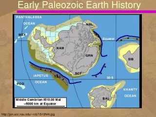
Early Paleozoic Global History • In contrast to today's global geography, • the Cambrian world consisted • of six major continents • dispersed around the globe at low tropical latitudes • Water circulated freely among ocean basins, • and the polar regions were mostly ice free • By the Late Cambrian, • epeiric seas had covered areas of • Laurentia, Baltica, Siberia, Kazakhstania, China, • while highlands were present in • northeastern Gondwana, eastern Siberia, and central Kazakhstania
Ordovician and Silurian Periods • Plate movements played a major role • in the changing global geography • Gondwana moved southward during the Ordovician and began to cross the South Pole • as indicated by Upper Ordovician tillites found today in the Sahara Desert • In contrast to Laurentia’s passive margin in the Cambrian, • an active convergent plate boundary formed along its eastern margin during the Ordovician • as indicated by the Late Ordovician Taconic orogeny that occurred in New England
Early Paleozoic Evolution of North America • The geologic history of the North American craton may be divided into two parts • the first dealing with the relatively stable continental interior over which epeiric seas transgressed and regressed, • and the other dealing with the mobile belts where mountain building occurred • In 1963 American geologist Laurence Sloss proposed • that the sedimentary-rock record of North America • could be subdivided into six cratonic sequences
Cratonic Sequences of N. America • That are separated by large-scale uncon-formities shown in brown • White areas represent sequences of rocks Appa-lachian oro-genies Cordilleran orogenies
Global Transgressive and Regressive Cycles • Geologists have also recognized • major unconformity bounded sequences • in cratonic areas outside North America • Such global transgressive and regressive cycles • are caused by sea-level changes • and are thought to result • from major tectonic and glacial events
Sequence Stratigraphy • Sequence stratigraphy is the study of rock relationships • within a time-stratigraphic framework of related facies • bounded by erosional or nondepositional surfaces • The basic unit of sequence stratigraphy is the sequence, • which is a succession of rocks bounded by unconformities • and their equivalent conformable strata
The Sauk Sequence • Rocks of the Sauk Sequence • during the Late Proterozoic-Early Ordovician • record the first major transgression onto the North American craton • Deposition of marine sediments • during the Late Proterozoic and Early Cambrian • was limited to the passive shelf areas of the • Appalachian and Cordilleran borders of the craton • The craton itself was above sea level • and experiencing extensive weathering and erosion
Cratonic Sequences of N. America • Brown areas = large-scale uncon-formities • White areas = sequences of rocks • Sauk sequence
The Sauk Sequence • Because North America was located • in a tropical climate at this time • and there is no evidence of any terrestrial vegetation, • weathering and erosion of the exposed • Precambrian basement rocks must have proceeded rapidly • During the Middle Cambrian, • the transgressive phase of the Sauk • began with epeiric seas encroaching over the craton
Cambrian Paleogeography of North America • During this time North America straddled the equator • Trans-continental Arch
The Sauk Sediments • The sediments deposited • on both the craton • and along the shelf area of the craton margin • show abundant evidence of shallow-water deposition • The only difference • between the shelf and craton deposits • is that the shelf deposits are thicker • In both areas, • the sands are generally clean and well sorted • and commonly contain ripple marks • and small-scale cross-bedding
Sauk Carbonates • Many of the carbonates are • bioclastic • composed of fragments of organic remains • contain stromatolites, • or have oolitic textures • contain small, spherical calcium carbonate grains • Such sedimentary structures and textures • indicate shallow-water deposition
Transgression • A transgression covered • the Grand Canyon region • the Tapeats Sandstone represents • the basal transgressive shoreline deposits • that accumulated as marine waters • transgressed across the shelf • and just onto the western margin • of the craton during the Early Cambrian
Cambrian Transgression • The three formations exposed • along the Bright Angel Trail, Grand Canyon Arizona • Cambrian strata exposed in the Grand Canyon
Upper Cambrian Sandstone • Outcrop of cross-bedded Upper Cambrian sandstone in the Dells area of Wisconsin
Regression and Unconformity • As the Sauk Sea regressed • from the craton during the Early Ordovician, • it revealed a landscape of low relief • The rocks exposed were predominately • limestones and dolostones • that experienced deep and extensive erosion • because North America was still located in a tropical environment • The resulting craton-wide unconformity • marks the boundary between the Sauk • and Tippecanoe sequences
Cratonic Sequences of N. America • brown areas = large-scale uncon-formities • White areas = sequences of rocks • Tippecanoe sequence • Regression
The Tippecanoe Sequence • A transgressing sea deposited the Tippecanoe sequence over most of the craton • Middle Ordovician-Early Devonian • Like the Sauk sequence, this major transgression deposited clean, well-sorted quartz sands • The Tippecanoe basal rock is the St. Peter Sandstone, • an almost pure quartz sandstone used in manufacturing glass • that occurs throughout much of the mid-continent • and resulted from numerous cycles of weathering • and erosion of Proterozoic and Cambrian sandstones • deposited during the Sauk transgression
Ordovician Period • Paleo-geography of North America • showing change in the position of the the equator • The continent • was rotating counter-clockwise
Transgression of the Tippecanoe Sea • Resulted in the deposition of • the St. Peter Sandstone • Middle Ordovician • over a large area of the craton
Tippecanoe Reefs and Evaporites • Organic reefs are limestone structures • constructed by living organisms, • some of which contribute skeletal materials to the reef framework • Today, corals, and calcareous algae • are the most prominent reef builders, • but in the geologic past other organisms • played a major role in reef building • Reefs appear to have occupied • the same ecological niche in the geological past • that they do today regardless of the organisms involved
Modern Reef Requirements • Because of the ecological requirements • of reef-building organisms, • present-day reefs, are confined • to a narrow latitudinal belt • between 30 degrees north and south of the equator • Corals, • the major reef-building organisms today, • require warm, clear, shallow water • of normal salinity for optimal growth
Present-Day Reef Community • with reef-building organisms
Barrier Reefs • Reefs typically are long, • linear masses forming a barrier between • a shallow platform on one side • and a comparatively deep marine basin • on the other side • Such reefs are known as barrier reefs • Reefs create and maintain a steep seaward front • that absorbs incoming wave energy • As skeletal material breaks off • from the reef front, • it accumulates along a fore-reef slope
Barrier Reef • Fore-reef slope • Barrier Reef
The Lagoon • The reef barrier itself is porous • and composed of reef-building organisms • The lagoon area is a low-energy, • quiet water zone where fragile, • sediment-trapping organisms thrive • The lagoon area can also become the site • of evaporitic deposits • when circulation to the open sea is cut off • Modern examples of barrier reefs • are the Florida Keys, Bahama Islands, • and Great Barrier Reef of Australia
Ancient Reefs • Reefs have been common features since the Cambrian • and have been built by a variety of organisms • The first skeletal builders of reeflike structures • were archaeocyathids • These conical-shaped organisms lived • during the Cambrian and had double, • perforated, calcareous shell walls • Archaeocyathids built small mounds • that have been found on all continents • except South America
Stromatoporoid-Coral Reefs • Beginning in the Middle Ordovician, • stromatoporoid-coral reefs • became common in the low latitudes, • and similar reefs remained so throughout the rest of the Phanerozoic Eon • The burst of reef building seen in the Late Ordovician through Devonian • probably occurred in response to evolutionary changes • triggered by the appearance • of extensive carbonate seafloors and platforms • beyond the influence of detrital sediments
Silurian Period • Paleogeography of North America during the Silurian Period • Reefs developed in the Michigan, Ohio, and Indiana-Illinois-Kentucky areas
Michigan Basin Evaporites • The Middle Silurian rocks of the present-day Great Lakes region • Tippecanoe sequence • are famous for their reef and evaporite deposits • The most significant structure in the region • the Michigan Basin • is a broad, circular basin surrounded by large barrier reefs • These reefs contributed to increasingly restricted circulation • and the precipitation of Upper Silurian evaporates within the basin
Other Types of Reefs • Within the rapidly subsiding interior • of the basin, other types of reefs are found • Pinnacle reefs are tall, • spindly structures up to 100 m high • They reflect the rapid upward growth • needed to maintain themselves near sea level • during subsidence of the basin • Besides the pinnacle reefs, • bedded carbonates and thick sequences of salt • and anhydrite are also found in the Michigan Basin
Northern Michigan Basin • Northern Michigan Basin sediments during the Silurian Period
Stromatoporoid Reef Facies • Stromato-poroid barrier-reef facies of the Michigan Basin