Download
1 / 11
110 likes | 345 Views
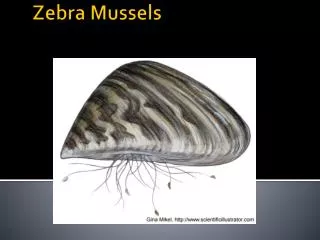
Mapping Freshwater Mussels. Caitlin LaBar October 15, 2009. Freshwater Mussels. Role in aquatic ecosystems Conservation & management. Caitlin LaBar. Marie Fernandez, USFWS. Western Species. Margaritifera falcata Gonidea angulata Genus Anodonta : A. beringiana

E N D
Mapping Freshwater Mussels Caitlin LaBar October 15, 2009
Freshwater Mussels • Role in aquatic ecosystems • Conservation & management Caitlin LaBar Marie Fernandez, USFWS
Western Species Margaritifera falcata Gonidea angulata Genus Anodonta: A. beringiana A.nuttalliana/ californiensis A. oregonensis/ kennerlyi A. dejecta (?)
Database also includes literature references, museum catalog numbers, coordinates, and other information for 3,000+ records
How to map the records? By point? Pro: Records mapped by exact location Con: Many records do not have coordinates or specific locations, making this a time-consuming process By stream or lake? Pro: Records mapped by stream segment or lake they were found in Con: Time-consuming and not feasible for some of the stream/lake layers available for the 12 states and 3 provinces By watershed? Pro: Less time-consuming and still shows more detail than mapping by county or state Con: Does not show the exact location the mussel was found
Creating the map Layers: • State and Province • County • HUC (USA) & Watershed (Canada) • Lake • River/stream • Cities Clip layers to the study area
Adding records • Copied HUC/Wshed layer and added new fields for Pre/Post 1945, 1985, and 2000 • Made one copy of the new layer for each species • Used the base map to find the HUC/Wshed for each mussel record • Add a “yes” into appropriate cells in the table
Mapped “historical”, “current”, and “unknown” records for each mussel species
Resources & Acknowledgments Identification guide www.xerces.org/freshwater-mussel-guide