Download
1 / 40
410 likes | 596 Views
Warm-up Questions 1-4. I always wanted to be a blonde!. Warm-up Question #1. 1) Which of the following maps would have the largest scale? A) World B) Country C) City D) Neighborhood. Warm Up Question #2. 2) Who is often known as the father of modern geography? A) Aristotle B) Columbus

E N D
Warm-up Questions 1-4 I always wanted to be a blonde!
Warm-up Question #1 • 1) Which of the following maps would have the largest scale? • A) World • B) Country • C) City • D) Neighborhood
Warm Up Question #2 • 2) Who is often known as the father of modern geography? • A) Aristotle • B) Columbus • C) Jay Z • D) Ptolemy
Warm up Question #3? • Which of the following would be the best to use to determine the best location for a new highway? • A) GIS • B) GPS • C) Remote Sensing • D) HCG
Warm-up Question #4 • How many satellites must a receiver be able to locate to determine a GPS location? • A) 1 • B) 2 • C) 3 • D) 4
1-2 Basic Concepts Key Question: How and why is each point on Earth Unique?
I. PLACE (4 ways) Same Country – Same Place??????
Toponym Example Toponym means…”the church of Mary In the hollow of the white hazel near The fierce whirlpool and the Church of Tysilio by the Red Cave” (in English) No, this is NOT me!
B) Site • The physical description of a place -Important Choice* -Humans can…* Modify!!!
C) Situation • Location of a place RELATIVE to other places. • Common directions* • Very Important for…*
D) Mathematical Location1 – Longitude (Meridians) • Arcs * • Prime Meridian* • 0 – 180 degrees east or west* • Man-made* • Time* (Greenwich Mean Time)
What Time is It? (pg 18)(answers only) • 1) If it is 2 pm in New York, what time is it here? • 2) If it is 2 pm in New York, what time is it in Denver? • 3) If it is 2 pm here, what time is it in Moscow? • 4) If it is 4 pm here, what time is it in California? • 5) if it is 2 pm here, what time is it in Japan?
What time is it - Answers • 1 ) 2 pm • 2) 12 noon • 3) 10 pm • 4) 1 pm • 5) 4 am TOMORROW!
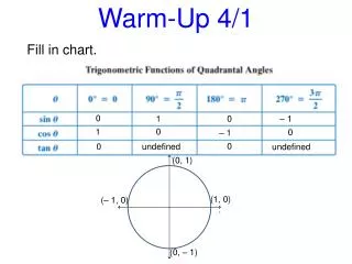
2- Latitude (parallels) • Equator* • Length* • 0 to 90 degrees* • Science*
A) Cultural Landscape (AKA Regional Studies) • 1 - Definition Just what name says: -Combo of: culture* and physical*
The Behavior of People* 2 – Fundamental principal of study of cultural landscape
3 – Spatial Association • A geographers job is to….* “the why of where?”
B) What is a Region? • Definition: any area defined by one or more characteristics (physical, cultural, economic,etc.). • Scale* • More than one*
Note to teacher: Video about US States • http://youtu.be/_E2CNZIlVIg
C) Types of Regions (3)1 – Formal Region • Definition: an area in which most people have a common characteristic. • Borders* • Examples*
2 – Functional Region • Definition - area organized around a focal point (AKA “nodal region”) • Borders* • Examples* • Technology*
3 – Vernacular (Perceptual) Region • Definition: area that people believe exists due to their cultural/historical identity • Mental Map* • Borders* • Examples*
Examples of Regions (Text) • For Each Figure: • Title: • Describe what you’re looking at • Why Important as an example Figure 1-14 (pg 19) • Figure 1-15 (pg 20) • Figure 1-16 (pg 21)
III. 2 Ways to Look at Culture: • A) - What People Care About – ideas, beliefs, values • Examples* • B) - What People Take Care of – production of material wealth -Examples*
C) MDC’s vs. LDC’s • 1 – MDC is…* - LDC is…* 2 – As Regions: MDC’s include North America, Europe and Japan (mostly) LDC’s include Africa, Asia and Latin America. (mostly)
3) Countries compete for the wealth of the world! (Globalization) L D C M D C
The End! The END! The End!