Download
1 / 15
150 likes | 156 Views
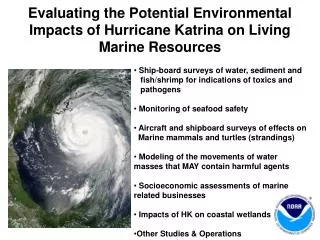
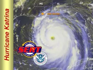
Mapping the Impacts of Marine Debris Left in the Wake of Hurricane Katrina 61 st Interdepartmental Hurricane Conference 7 March, 2007 Brendan M. Bray NOAA Marine Debris Program Gulf of Mexico Marine Debris Project. Hurricane Katrina impacts Major shipping channels were surveyed and cleared

E N D
Mapping the Impacts of Marine Debris Left in the Wake of Hurricane Katrina 61st Interdepartmental Hurricane Conference 7 March, 2007 Brendan M. Bray NOAA Marine Debris Program Gulf of Mexico Marine Debris Project
Hurricane Katrina impacts Major shipping channels were surveyed and cleared Near shore fishing and recreation areas had not been surveyed Funding from Congress to NOAA Background
Gulf of Mexico Marine Debris Project Goals • Support improvement of fishing and recreational conditions • Support efficient and cost-effectivedebris removal • Public outreach to regional stakeholders
Hurricane Katrina deposited huge amounts of debris in the Northern Gulf of Mexico coastal zone
Sunken vessel in Lake Borgne, LA Visible danger to navigation in Biloxi Bay
NOAA hazard surveys Side scan image – Mobile Bay, AL Side scan sonar array
Project GIS and Mapping Products • Project Web site • Maps and data • Photos and graphics • Links to partner organizations • Relevant publications and media • Integrated debris database • Static maps (PDF format) depicting location of debris found, debris dimension, sounding depth, clearance depth, etc. • Internet Map Server (IMS) Static map of entrance to Biloxi Bay, MS
http://gulfofmexico.marinedebris.noaa.gov • Marine debris maps and data for each survey zone • Internal /external links to project partners • Media information, related publications, photos, and video • Link to interactive internet mapping server (Arc IMS)
Mississippi Survey Debris Areas Internet Mapping Server (IMS)
Marine Debris Density Model Future Applications Model depicts debris density surface derived from actual survey data; 2006 / 2007 • OBJECTIVE: Increase efficiency of post-incident response to marine debris. • Debris density can be estimated using widely available information: • hurricane track • coastal zone population data • coastal damage polygons • general information on currents and winds • data depicting environmental sensitivity
Actual survey coverage in pink with identified debris items to date (black) FEMA damage polygons: Red – catastrophic damage ; Orange – extensive damage; Yellow – moderate to light damage
Debris Impacts and Environmental sensitivity Map of sensitive benthic habitats (sea grasses in green, oyster reefs in purple) for Mobile Bay, AL
Marine Debris Removal Efforts Alabama Debris Survey Areas
Thank You • NOAA Marine Debris Program • NOAA Office of Response and Restoration • NOAA Office of Coast Survey • Research Planning, Inc. • Genwest Systems • Mississippi Department of Marine Resources • Louisiana Department of Wildlife and Fisheries • Alabama Department of Conservation and Natural Resources Contact the Gulf of Mexico Marine Debris Project Team Email: gomdebris@noaa.gov Web: http://gulfofmexico.marinedebris.noaa.gov http://marinedebris.noaa.gov