Download
1 / 2
20 likes | 117 Views
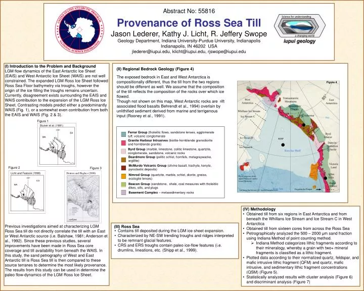
(II) Regional Bedrock Geology (Figure 4). The exposed bedrock in East and West Antarctica is compositionally different, thus the till from the two regions should be different as well. We assume that the composition of the till reflects the composition of the rocks over which ice flowed.

E N D
(II) Regional Bedrock Geology (Figure 4) The exposed bedrock in East and West Antarctica is compositionally different, thus the till from the two regions should be different as well.We assume that the composition of the till reflects the composition of the rocks over which ice flowed. Though not shown on this map, West Antarctic rocks are rift associated flood basalts Behrendt et al., 1994) overlain by unlithified sediment derived from marine and terrigenous input (Rooney et al., 1991). • Contains till deposited during the LGM ice sheet expansion. • Characterized by NE-SW trending troughs and ridges interpreted to be remnant glacial features. • CRS and ERS troughs contain paleo ice-flow features (i.e. drumlins, lineations, etc. (Shipp et al., 1999). (III) Ross Sea Figure 1 Stuiver et al. (1981) Figure 4 180o 180o E EA WA Figure 3 Denton and Hughes (2000) Figure 2 Ice Stream D RISP Licht and Fastook (1998) 180o 180o Ice Stream E E A WA From American Map Folio series, 1970 – American Geographical Society Pre-Cretaceous strata, upper Paleozoic and/or lower Mesozoic Figure 3 David Glacier Ferrar Group (tholeiitic flows, sandstone lenses, agglomerate tuff, volcanic conglomerate Drygalski Ice Tongue Granite Harbour Intrusives (biotite-hornblende granodiorite and hornblende granite) Byrd Group (marble, limestone, oolitic limestone, quartzite, conglomerate, sandstone, volcanic rocks Beardmore Group (pelitic schist, hornfels, metagraywacke, argillite) McMurdo Volcanic Group (olivine basalt, trachyte, kenyte, pyroclastic deposits) Nimrod Group (quartzite, marble, schist, diorite, gneiss, ecologite lenses) Beacon Group (sandstone, shale, coal measures with tholeiitiic dikes, sills, and plugs Basement Complex – metasedimentary rocks Abstract No: 55816 Provenance of Ross Sea Till Jason Lederer, Kathy J. Licht, R. Jeffery Swope Geology Department, Indiana University-Purdue University, Indianapolis Indianapolis, IN 46202 USA jlederer@iupui.edu, klicht@iupui.edu, rjswope@iupui.edu (I) Introduction to the Problem and Background LGM flow dynamics of the East Antarctic Ice Sheet (EAIS) and West Antarctic Ice Sheet (WAIS) are not well constrained. The expanded LGM Ross Ice Sheet followed Ross Sea Floor bathymetry via troughs, however the origin of the ice filling the troughs remains uncertain.Currently, disagreement exists surrounding the EAIS and WAIS contribution to the expansion of the LGM Ross Ice Sheet. Contrasting models predict either a predominantly WAIS (Fig. 1), or a somewhat even contribution from both the EAIS and WAIS (Fig. 2 & 3). Previous investigations aimed at characterizing LGM Ross Sea till do not directly correlate the till with an East or West Antarctic source (i.e. Balshaw, 1981; Anderson et al., 1992). Since these previous studies, several improvements have been made in Ross Sea core coverage and till availability from beneath the WAIS. In this study, the sand petrography of West and East Antarctic till is Ross Sea till is then compared to these source terranes to determine the most likely provenance. The results from this study can be used in determine the paleo flow-dynamics of the LGM Ross Ice Sheet. Stuiver et al. (1981) Stuiver et al., 1981 • (IV) Methodology • Obtained till from six regions in East Antarctica and from beneath the Whillans Ice Stream and Ice Stream C in West Antarctica • Obtained till from sixteen cores from across the Ross Sea • Petrographically analyzed the 500 – 2000 μm sand fraction using Indiana Method of point counting method. • Indiana Method categorizes lithic fragments according to their mineralogy, whereby a grain with two+ mineral fragments is classified as a lithic fragment. • Plotted data according to their normalized quartz, feldspar, and mafic intrusive lithic fragment (QFM) and quartz, mafic intrusive, and sedimentary lithic fragment concentrations (QSM) (Figure 5). • Statistically analyzed results with cluster analysis (Figure 6) and discriminant analysis (Figure 7)
(V) Results Function 2 Figure 7.Discrminant analysis plots: ellipses represent the 95% confidence interval surrounding the average grouping score for each cluster. Function 3 Function 2 Function 1 Function 2 Function 1 -2000 a. Figure 5 • Confirms that the groups formed by cluster analysis are statistically distinct. • Determines which mineral and lithic fragments components in the till are important factors in forming the cluster groups. Darwin 1 Upper Beardmore Hatherton Ice Stream C Ice Stream C Whillans Ice Stream Whillans Ice Stream NBP9501 - 17 EA (1) DF80 - 193 EA + RS (3) DF80 - 193 NBP9501 - 11 NBP9501 - 17 NBP9501 - 17 NBP9501 - 17 RISP EA WA RS RISP NBP9501 - 24 2b 2a 2 2d NBP9501 - 12 NBP9501 - 07 NBP9902 - 08 NBP9902 - 17 2c NBP9902 - 04 NBP9902 - 04 NBP9907 - 63 NBP9902 - 16 NBP9902 - 05 Hatherton/Darwin NBP9501 - 35 EL32 - 13 NBP9501 - 35 NBP9501 - 30 EL32 - 13 Function 1: felsic igneous fragments Intermediate igneous fragments extrusive volcanic fragments opaque minerals calcite potassium feldspar plagioclase mudstone fragments sandstone fragments claystone fragments Function 2: metamorphic igneous fragments mafic igneous fragments biotite iron ore quartz olivine chlorite Function 1: intermediate igneous fragments metamorphic fragments extrusive volcanic fragments limestone fragments sandstone/siltstone fragments claystone fragments pyroxene potassium feldspar biotite chlorite Function 2: mudstone fragments mafic fragments felsic fragments olivine iron ore calcite quartz Function 3: opaque minerals muscovite EL32 - 13 DF80 - 193 EL32 - 13 Upper Beardmore Central Beardmore NBP9401 - 01 Darwin Terminus DF80 - 193 East Antarctica NBP9501 - 11 Western Ross Sea 3 NBP9501 - 17 West Antarctica NBP9401 - 01 Mt. Achernar Eastern Ross Sea Allan Hills Central Ross Sea RISP • East Antarctic and West Antarctic Till Composition • East and West Antarctic till reflect regional geology. • East Antarctic till is dominantly mafic intrusive, felsic intrusive, metamorphic (quartzite, calcite), sedimentary (mudstone), volcanic extrusive. • West Antarctic till is dominantly well rounded quartz, feldspar, felsic intrusive – distinctive feature to is biotite,quartz,hornblend, and/or chlorite – rich felsic intrusive fragments. Sediment likely derived from Transantarctic Mountains to the north during ice free conditions. Figure 8. WA Beardmore Glacier Mercer Ice Stream Whillians Ice Stream Mt. Achernar EA Kamb Ice Stream Nimrod Glacier Holyoake Range Figure 9 Binschadler Ice Stream RISP Byrd Glacier Darwin Glacier MacAyel Ice Stream Ross Ice Shelf Hatherton Glacier Marie Byrd Land ? 9902 - 17 9902 - 04 9407 - 39 9501 - 17 Eastern Basin 9407 - 63 -500 Victoria Land Allan Hills 80 - 193 9501 - 12 9902 - 05 9401 - 01 ? 9902 - 08 9501 - 11 9501 - 24 9501 - 30 David Glacier 9501 - 07 -1000 EL - 32 ERS S 9501 - 35 Dryglaski Ice Tongue Pennell Bank 9501 - 39 JOIDES Basin Drygalski Trough Coulman Island WRS CRS • East and West Antarctic samples do not exhibit overlap. • Western Ross Sea (WRS) samples plot close to East Antarctic samples. • Eastern Ross Sea (ERS) samples plot close to West Antarctic samples. • Central Ross Sea (CRS) samples plot between ERS and WRS samples. • RISP samples plot similarly to West Antarctic samples on QSM ternary and similarly to East Antarctic samples on QFM ternary. Oolitic limestone hornblende quartz biotite SAL 3 – x-polars Magnification 400x Magnification 100x SAL 540 - ppl Oolitic limestone occurs in CRS LGM till and has one documented occurrence in Ross Embayment in the Shackleton Formation Limestone in the Holyoake Range near Nimrod Glacier (Fig. 9). Felsic igneous fragments with characteristic quartz, biotite, hornblende composition occur in West Antarctica and the CRS. quartz Magnification 100x Figure 6. Resulting dendogram from cluster analysis of till samples from East Antarctica, West Antarctica and Ross Sea. Sample Locations Cluster • Three clusters form at a Euclidean distance of ~9.5. • There are four subclusters of cluster 2 formed at a Euclidean distance of ~ 5. • Weak clustering between source terrane and Ross Sea tills, however, some overlap does occur. • The three areas of the Ross Sea cluster separately on dendogram. • There is little overlap between East and West Antarctic source area tills indicating that they are distinct. • (VI) Conclusions • East and West Antarctic source areas have distinct petrologic signatures. • Ross Sea till exhibits E-W petrologic variability. • WRS till exhibits petrographic similarities to adjacent areas of East Antarctica • ERS till exhibits petrographic similarities to adjacent West Antarctica • Although ERS and WRS are compositionally similar to adjacent areas of Antarctica, transport by ice has caused maturation of the lithologic and mineralogic counterparts. (Note: Particle size analysis results not presented here show that Ross Sea till has a smaller average particle-size than East and West Antarctic till) • CRS till exhibits compositional similarities to both ERS and WRS tills which can be used as proxies for East and West Antarctic source areas. Several Ross Sea till samples contain distinctive provenance indicators (i.e. oolitic limestone, calcite, marble, etc.) • Distinctive lithic fragments serve as tracers • Results suggest an moderately even contribution from the EAIS and WAIS to the expansion of the LGM Ross Ice Sheet, correlating well with the models of Fastook and Licht (1998) and Denton and Hughes (2000) following Ross Sea troughs (consistent with Shipp et al. (1999) paleo ice-flow directional indicators). A B ERSSAL306 C D References Anderson, J.B., Shipp, S.S., Bartek, L.R., and Reid, D.E., 1992, Evidence for a grounded ice sheet on the Ross Sea continental shelf during the Late Pleistocene and preliminary paleodrainage reconstruction. Marine Geology, v. 57, p.295 – 333. Balshaw, K.M., 1980, Antarctic glacial chronology reflected in the Oligocene through Pliocene sedimentary section in the Ross Sea. Ph.D. Thesis, Rice University, 140 p. Licht, K.J., and Fastook, J., 1998, Constraining a numerical ice sheet model with geologic data over one ice sheet advance/retreat cycle in the Ross Sea. Chapman Conference on the West Antarctic Ice Sheet, University of Maine, p.25-26. Shipp, S.S., Anderson, J.B., and Domack, E.W., 1999, Seismic signature of the Late Pleistocene fluctuation of the West Antarctic Ice Sheet system in the Ross Sea: A new perspective, Part 1. Geological Society of America Bulletin, V.111, n.10, p.1486 – 1516. Stuiver, M., Denton, G.H., Hughes, T.J., and Fastook, J.L., 1981, History of the marine ice sheets in West Antarctica during the last glaciation: A working hypothesis. In Denton, G.H. and Hughes, T.J.eds, The last great ice sheets: New York, Wiley-Interscience, p.319-439. Acknowledgements: Contributors: H. Engelhardt – California Institute of Technology, J. Bockheim – University of Wisconsin – Madison, G. Faure – The Ohio State University, T. Janecek – Florida State University, Antarctic Research Facility Funding from the Geological Society of America, NSF Office of Polar Programs, IUPUI Geology and Graduate School Dr. Kathy Licht, Dr. R. Jeffery Swope, Dr. Andy Barth, Dr. Joe Pachut (statistics), Bob E. Hall and Dr. Jeffery Wilson (GIS)