Download
1 / 15
150 likes | 278 Views
Hydrological evaluation of satellite precipitation products in La Plata basin. 1 Fengge Su, 2 Yang Hong, 3 William L. Crosson, and 4 Dennis P. Lettenmaier 1,3 USRA at NSSTC/NASA/MSFC, Huntsville, AL 2 University of Oklahoma, Norman, OK

E N D
Hydrological evaluation of satellite precipitation products in La Plata basin 1Fengge Su, 2Yang Hong, 3William L. Crosson, and 4Dennis P. Lettenmaier 1,3USRA at NSSTC/NASA/MSFC, Huntsville, AL 2University of Oklahoma, Norman, OK 4University of Washington, Seattle, WA
1. Objective • To evaluate the satellite-based precipitation estimates, and their utility in hydrologic predictions. • To provide insights into the potential utility of Global Precipitation Measurement mission (GPM) products for hydrologic applications. • To make a first step toward a hydrologically based global assessment framework for satellite-based precipitation products (particularly those using minimal in situ data).
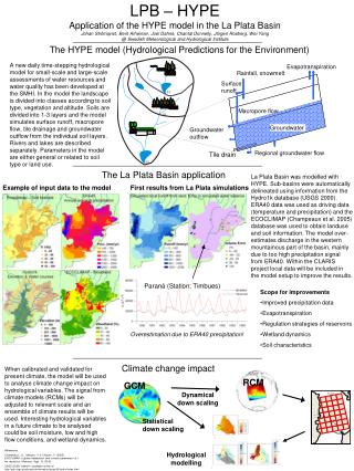
2. Data sets and methodology Satellite-based precipitation: (1) The TRMM Multi-satellite Precipitation Analysis (TMPA) research product 3B42 V.6 and real-time version 3B42-RT (Huffman et al 2007) . (2) The Precipitation Estimation from Remotely Sensed Information Using Artificial Neural Networks (PERSIANN) (Sorooshian et al 2000). (3) The Climate Prediction Center morphing method (CMORPH) (Joyce et al 2004). Data resolution: 3-hour time step and 0.25° degree spatial resolution. Study period: January 1, 2003 ~ August 31, 2006 Study area: La Plata basin (-38 ° S ~ -14 ° S, -56 ° W ~ -41 ° W, 3.1×10⁶ km2) All three products are satellite only (no gauge-based post-processing, as in TMPA RP)
Gauge-based precipitation in La Plata basin South American gridded daily precipitation (0.25 °) constructed from daily meteorological station data (Liebmann and Allured, 2005). Four sub-basins (highlighted)have relatively dense station coverage.
Methodology • Spatially-distributed and basin-wide precipitation estimates from satellite precipitation products are compared with gauge-derived precipitation at time scales from annual to daily for the period 2003 through 2005. • The Variable Infiltration Capacity (VIC) land surface hydrology model is forced by the daily satellite-based and gridded gauge precipitation estimates over La Plata basin. Simulated runoff fields and streamflow driven by satellite precipitation are compared with those driven by gauge precipitation inputs.
3. Precipitation evaluation- spatial fields Gauge Annual mean precipitation over La Plata basin from gridded gauge, TMPA V.6 (gauge adjusted), TMPA-RT, CMORPH, and PERSIANN estimates for the years 2003-2005. TMPA V.6 mm/yr Difference of annual precipitation between satellite and gauge estimates. mm/yr
Basin-averaged precipitation Basin 6682 Basin 6301 Basin 6598 Basin 3802 Scattergrams of daily basin-averaged precipitation from gauge and satellite estimates for four sub-basins in La Plata for the period 2003 to 2005. Bias = 0.17 Bias = 0.11 Bias = 0.10 Bias = 0.09 Bias = 0.36 Bias = 0.08 Bias = 0.24 Bias = 0.42 PERSIANN CMORPH TMPA-RT TMPA V.6 Bias = 0.44 Bias = 0.16 Bias = 0.31 Bias = 0.49 Bias = 0.63 Bias = -0.03 Bias = 0.31 Bias = 0.19 Gauged (mm/dy) Gauged(mm/dy) Gauged (mm/dy) Gauged (mm/dy)
Bias relative to gauge estimates for each year ( 2003, 2004, and 2005). The bias significantly decreased in 2005 over basins 3802 and 6598 for the three real-time satellite precipitation products.
4. Hydrological Modelling • Model features: • multiple vegetation classes in each cell; • energy and water budget closure at each time step; • subgrid infiltration and runoff variability; • and non-linear baseflow generation. The VIC (Liang et al, 1994;1996) model is a grid-based land surface scheme designed both for inclusion in GCMs, and for use as a stand-alone macro-scale hydrological model.
Spatial fields of annual mean simulated runoff (2003-2005) Gauge TMPA V.6 Annual mean simulatedrunoff forced by the gauge, TMPA V.6, TMPA-RT, CMORPH, and PERSIANN estimates for the years 2003-2005. mm/yr Difference of annual simulated runoff between satellite-driven and gauge-observation-driven simulations. mm/yr
Simulated with satellite Precip Simulated with gauge Precip Daily simulated streamflow for basin 3802, Uruguay at Paso de los Libres (Area: 189, 300km2, Jan 2003~Aug 2006)
Simulated with satellite Precip. Simulated with gauge Precip. Daily simulated streamflow for basin 6598, Iguazu at Estreito (Area: 63,236 km2, Jan 2003~Aug 2006)
Simulated with satellite Precip. Simulated with gauged Precip. Daily simulated streamflow for basin 6301, Parana at Jupia (Area: 478,000km2, Jan 2003 - Aug 30 2006)
Summary • All satellite precipitation products captured the general precipitation regime of the La Plata basin, but with significant overestimation compared with gauge estimates over the middle part of the basin and slight underestimation in the northeastern part. • The four satellite products show different performance over different sub-basins, indicating the effects topography and possibly land cover on the precipitation retrieval algorithms. • Biases of the precipitation estimates significantly decreased in 2005 over the central sub-basins, likely due to algorithm changes and increased coverage from microwave sensors. • The plausible performance of the satellite products in streamflow simulations in recent years suggests that even without the monthly gauge correction, there is considerable potential for hydrologic prediction using satellite precipitation estimates in data sparse areas. • Further evaluation is needed with more complete daily gauge data over other global river basins.