Download
1 / 17
170 likes | 309 Views
New and Updated Operational Tropical Cyclone Wind Products. John A. Knaff – NESDIS/ StAR - RAMMB, Fort Collins, CO Alison Krautkramer – NCEP/TPC - NHC, Miami, FL Mark DeMaria – NESDIS/ StAR - RAMMB, Fort Collins, CO Andrea Schumacher – CIRA/CSU, Fort Collins, CO. Outline.

E N D
New and Updated Operational Tropical Cyclone Wind Products John A. Knaff – NESDIS/StAR - RAMMB, Fort Collins, CO Alison Krautkramer – NCEP/TPC - NHC, Miami, FL Mark DeMaria – NESDIS/StAR - RAMMB, Fort Collins, CO Andrea Schumacher – CIRA/CSU, Fort Collins, CO
Outline • Planned updates to the operational CIRA/NESDIS – NCEP AMSU tropical cyclone intensity and structure algorithm • Current algorithm and uses • Planned updates • Possible new use • Schedule • Plans for a new operational Multiplatform Tropical Cyclone Surface Wind Analysis (MTC-SWA) product • Description of the new product • 2007 verification (H*Wind, best track wind radii) • Planned products • Schedule 62nd Interdepartmental Hurricance Conference
Current Product • Uses the Advanced Microwave Sounding Unit (AMSU) from NOAA – 15, -16, -18 • Fix or Vmax, MSLP, & wind radii estimates • Radial vs. Height cross-sections of pressures, balance winds & temperatures on height surfaces • Horizontal heights, temperatures, & winds on standard pressure surfaces • Statistics related to the fix estimate 62nd Interdepartmental Hurricance Conference
Some Current Uses • Operational intensity and structure guidance • Phase space diagrams (Bob Hart, FSU) • Near surface winds (MTC-SWA, plans for H*wind) • Examining extratropical transition (Pat Harr) 62nd Interdepartmental Hurricance Conference
Planned Updates and Demonstrations Additional AMSU data • NASA Aqua • European Met-Op New Utilizations • MTC-SWA, H*Wind • Vertical Wind Shear estimates • Depth of the steering level 62nd Interdepartmental Hurricance Conference
Example of the 2-d Winds 62nd Interdepartmental Hurricance Conference
Estimates of Vertical Wind Shear • 2004-2007 North Atlantic Tropical Cyclones • NCEP 6o average • Versus • AMSU 6o average 62nd Interdepartmental Hurricance Conference
Schedule (Time Table) • May 2008 – Project starts • Requested through TPC Spring 2008 - NCO to develop BUFR readers (Aqua and Met Op) • Received - Get statistical retrieval coefficients from NESDIS • Summer 2008 - Coordinate with TPC • Summer 2008 - Modify Code to accept Aqua and Met Op data • Fall/Winter 2008 – testing with TPC help • Spring 2009 - Transition to operations at NCO 62nd Interdepartmental Hurricance Conference
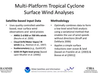
MTC-SWA Description • Optimally combines and quality controls satellite-based, near surface wind observations and proxy winds • AMSU 2-d 850 or 700 hPa winds (Bessho et al 2006) • Cloud Drift/Water Vapor/ IR winds (e.g., Nieman et al., 1997) • Scatterometery (QuikSCAT, A-SCAT) • GOES IR flight-level proxy (Mueller et al 2006 with a few modifications) • Creates a low-level wind field analysis (Variational approach, weighted) • Applies a simple surface reductions over ocean & land which are loosely based on Franklin et al (2003) & Boose et al (2001) 62nd Interdepartmental Hurricance Conference
Input: Hurricane DEAN 200720 August06 UTC 62nd Interdepartmental Hurricance Conference
Analysis: Hurricane Dean 200720 August06 UTC 62nd Interdepartmental Hurricance Conference
Verification/Comparison vs. H*Wind 62nd Interdepartmental Hurricance Conference
Verification/Comparison vs. NHC wind radii Wind Radii Errors Detection of Wind Radii *Climatology from Knaff et al. (2007) 107,66,42 nmi for R34,50 & 64 HKD = (Hit Rate) – (False Alarm Rate) 62nd Interdepartmental Hurricance Conference
Planned Products • ATCF (JTWC & NHC) • Analysis Fix (PR; Vmax, RMW, R34, R50, R64, MSLP) • CIRA/RAMMB Tropical Cyclone Web Site • Analysis Plots • Dynamic MSLP estimation • Flight-level kinetic energy estimation matching Maclay et al. (2008) methodology. 62nd Interdepartmental Hurricance Conference
Examples Dynamical MSLP estimation Kinetic Energy (0-200km) Flight-level KE Felix (2007) 62nd Interdepartmental Hurricance Conference
Schedule for MTC-SWA • May 2008 – Project Starts • Summer 2008 – Run Experimental Product at CIRA & Establish data flow at NESDIS • Winter 2008 - Install Software at NESDIS, Verify output , modify algorithm as necessary • Spring 2009 - Begin running the product at NESDIS • Winter 2009 – Develop the NESDIS/SSD Web Page, dissemination to ATCF from NESDIS • Spring 2010 – Finish operational transition 62nd Interdepartmental Hurricance Conference
QUESTIONS? 62nd Interdepartmental Hurricance Conference