Download
1 / 21
240 likes | 529 Views
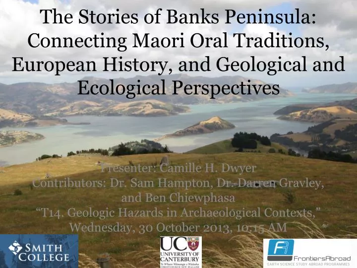
The Stories of Banks Peninsula: Connecting Maori Oral Traditions, European History, and Geological and Ecological Perspectives. Presenter: Camille H. Dwyer Contributors: Dr. Sam Hampton, Dr. Darren Gravley , and Ben Chiewphasa “T14. Geologic Hazards in Archaeological Contexts, ”

E N D
The Stories of Banks Peninsula: Connecting Maori Oral Traditions, European History, and Geological and Ecological Perspectives Presenter: Camille H. Dwyer Contributors: Dr. Sam Hampton, Dr. Darren Gravley, and Ben Chiewphasa “T14. Geologic Hazards in Archaeological Contexts,” Wednesday, 30 October 2013, 10:15 AM
Outline • Introduction to Banks Peninsula and the Maori • Main Question • Methods • Historical, Geological, Archaeological, and Anthropological Evidence Surrounding Tsunamis • Pa Locations • Remaining Questions and Significance
Banks Peninsula, New Zealand Figure Adapted from Hampton (2012)
Maori of New Zealand • First inhabitants arrived to North Island ~ 13th century C.E. (Te Ara, 2013). • Banks Peninsula inhabited by 2 iwi (tribe), the Waitaha & Ngati Mamoe ~ 14th to 16thcentury (Bassett et al. 2004 & Stack, 1893). • Early 1600s, Maori iwi, Ngāi Tahu settled in Banks Peninsula (Te Maire Tau, 2012) http://www.teara.govt.nz/files/32146-wmu.jpg
Pa = Fortified Settlement Photo: http://theprow.org.nz/assets/Maori/Taupo-pa.jpg
Do Maori settlement patterns on Banks Peninsula reflect an understanding of and response to naturally occurring phenomena such as tsunamis and their associated hazards? Photo Courtesy of Paula Bürgi- Pa Bay
Methods • Understand the European historical and scientific perspectives • Interpret oral tradition • Historical and Symbolic • Interviews with kaitiaki (guardian/ elder) from Ōnuku Marae in Akaroa Harbour and Maori Resources Librarian, NekenekeiteRangiPaul
Methods Continued • Maps of pa sites (Taylor, 1894; Challis, 1995) • To understand the geological landscape consulted Google Earth and The Tattooed Land: The Southern Frontiers of the Pa Maori (Brailsford, 1981) Photo Courtesy of Paula Bürgi- Pa Island
Tsunami Evidence • History • Geology • Archaeology • Oral Tradition: • Taniwha • Pa of Nga-Toko-Ono Photo Courtesy of Paula Bürgi- Pa Island
European Historical Evidence • European Historical examples include: 1868 and 1960 http://media.treehugger.com/
Natural Hazards 1868 Tsunami impact on Okains Bay Bridge http://christchurchcitylibraries.com/heritage/maps/169109.jpg
Scientific Evidence • Record of 7 paleotsunamis (Goff & Chagué- Goff, 2012). • Only concerned about 1250 -1350 C.E. and 1604 C.E. Photo Courtesy of Jane Eisenberg- Waka
Scientific Evidence Archaeological Evidence: Inhabited Cave Geological Evidence: Tsunami Deposit Couplets from Okains Bay Figure Adopted from Goff and Chagué- Goff (2012)
Taniwha = Giant Sea Lizard http://www.worth1000.com/contests/21347/cryptozoo-8
Pa of Nga-Toko-Ono and Chatham Islands Figure Adopted From Stevens & Chiswell (2012)
Biggest threat to New Zealand’s east coast are transoceanic tsunamis triggered by high magnitude South American earthquakes. • Tsunami effects are greater on Northern and Eastern Banks Peninsula. Photo Courtesy of Kyle Metcalfe- Banks Peninsula
Pas of Banks Peninsula Elevation: Tsunami Risk Low Elevation: High Combination: Medium High Cliffs: Minimal Low Elevation: None Figure Modified from Challis (1995)
Lingering Questions Did the Ngāi Tahu move to Banks Peninsula after the 1604 C.E. tsunami to look for more natural resources as well as higher ground to construct pas because of another impending tsunami event? Photo Courtesy of Kyle Metcalfe- Waitangi Day
Research Significance • When there is not an obvious geological record, researchers can use oral traditions to supplement and enhance it. • Learning from the past can help modern day Kiwis become aware of transoceanic tsunamis and their associated hazards Photo Courtesy of Paula Bürgi-East Okains Bay
Summary • Maori and Banks Peninsula • Main Question • Read articles, interpreted oral traditions, and consulted maps • European perspectives, Geological, Archaeological, and Oral Traditions for tsunami evidence • East coast pas reflect understanding, but north coast pas do not. • Oral Traditions can help to supplement the geological record
Questions cdwyer@smith.edu Photo Courtesy of AlexaZilberfarb - Akaora Harbour