Download
1 / 1
10 likes | 184 Views
2-D DEPTH-AVERAGED DELFT3D HURICANE ISAAC MODEL FOR LOWER MISSISSIPPI RIVER ON SIMULOCEAN . University of New Orleans, 2000 Lakeshore Drive, CERM building, Suite 318, New Orleans, LA 70148, U.S.A. . ABSTRACT.

E N D
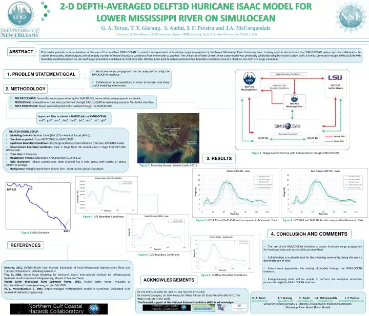
2-D DEPTH-AVERAGED DELFT3D HURICANE ISAAC MODEL FOR LOWER MISSISSIPPI RIVER ON SIMULOCEAN University of New Orleans, 2000 Lakeshore Drive, CERM building, Suite 318, New Orleans, LA 70148, U.S.A. ABSTRACT This poster presents a demonstration of the use of the interface SIMULOCEAN to conduct an experiment of hurricane surge propagation in the Lower Mississippi River. Hurricane Isaac is being used to demonstrate that SIMULOCEAN system permits collaborators to submit simulations, share outputs and ultimately transfer of model boundary conditions from one model to another. The University of New Orleans River surge model was previously calibrated using Hurricane Gustav. Delft 3-D was submitted through SIMULOCEAN with boundary conditions based on LSU Gulf Surge Simulation and based on field data. HEC-RAS has been used to obtain upstream flow boundary conditions and as a check on the Delft 3-D surge simulation. • Hurricane surge propagation can be assessed by using the SIMULOCEAN interface. • Collaboration is accomplished in order to transfer and share useful modeling information. 1. PROBLEM STATEMENT/GOAL 2. METHODOLOGY • PRE-PROCESSING: Some files were prepared using the Delft3D GUI, some others were prepared externally • PROCESSING: Computational runs were performed through SIMULOCEAN by uploading essential files to the interface • POST-PROCESSING: Result were extracted and visualized through the Delft3D GUI • Important files to submit a Delft3D job on SIMULOCEAN: • .mdf*, .grd*, .enc*, .dep*, .bnd*, .bct*, .obs*, .crs*, .rgh* • DELFT3D MODEL SETUP: • Modeling Domain: Bonnet Carré (RM 127) – Head of Passes (RM 0) • Simulations period: From 08/27/2012 to 09/01/2012 • Upstream Boundary Conditions: Discharge at Bonnet Carré obtained from HEC-RAS UNO model • Downstream Boundary Conditions: Case 1: Stage from LSU model, case 2: Stage from HEC-RAS UNO model • Time step: 0.4minutes • Roughness: Variable Manning’s n ranging from 0.02 to 0.03 • Grid resolution: About 100mx100m. Main Channel has 9 cells across with widths of about 1000m in average • Bathymetry: Variable depth from 10m to 25m.. Most outlets about 10m depth Figure 1. Diagram of Interaction with Collaborators through SIMULOCEAN 3. RESULTS Figure 2. Modeling Domain (Visible Earth, 2001) RM 127 Figure 4. U/S Boundary Conditions Figure 7. HEC-RAS and Delft3D Results compared to Measured Data Figure 8. HEC-RAS and Delft3D Results compared to Measured Data RM 0 4. CONCLUSION AND COMMENTS Figure 3. Grid Overview • The use of the SIMULOCEAN interface to assess hurricane surge propagation for Hurricane Isaac was successfully accomplished. • Collaboration is a valuable tool for the modeling community, being this work a demonstration of that. • Future work approaches the nesting of models through the SIMULOCEAN interface. • Post-processing tools will be enable to perform the complete simulation process through the SIMULOCEAN interface. REFERENCES Figure 5. D/S Boundary Conditions Deltares, 2011, Delft3D-FLOW User Manual, Simulation of multi-dimensional hydrodynamicFlows and TransportPhenomena, includingsediments Thu, V., 2003, Storm Surge Modeling for Vietnam’s Coast, International Institute for Infrastructural, Hydraulic and Environmental Engineering, Master of Science Thesis Visible Earth: Mississippi River Sediment Plume, 2001, Visible Earth: Home. Available at http://visibleearth.nasa.gov/view_rec.php?id=1650 Ye, J., McCorquodale, J., 1997, Depth-AveragedHydrodynamicModel in CurvilinearCollocatedGrid, Journal of HydraulicEngineering Figure 6. Outflow Boundary Conditions ACKNOWLEDGEMENTS • Dr. Jim Chen, Dr. Kelin Hu and Dr. JianTao (NG-CHC, LSU) • Dr. Ioannis Georgiou, Dr. John Lopez, Dr. Mead Allison. Dr. Ehab Meselhe (NG-CHC, The Water Institute of the Gulf). • The financial support of the National Science Foundation (NSF) is acknowledged. • G. A. TeranT. T. GurungS. AminiJ.A. McCorquodale J. F. Pereira • gterango@uno.edu ttgurung@uno.edu samini1@uno.edu jmccorqu@uno.edu Jpereira@thewaterinstitue.org • University of New Orleans. CI Strategy 2: Community modeling framework. • Mississippi River Model (River Model)