Download
1 / 30
330 likes | 990 Views
2013 Esri International User Conference July 8–12, 2013 | San Diego, California. Technical Workshop. Migrating Parcel data into the Parcel Fabric Solution. Tim Hodson Amir Bar-Maor. Agenda. What is a Parcel Fabric? Loading data into a Parcel Fabric

E N D
2013 Esri International User Conference July 8–12, 2013 | San Diego, California Technical Workshop Migrating Parcel data into the Parcel Fabric Solution Tim Hodson Amir Bar-Maor
Agenda • What is a Parcel Fabric? • Loading data into a Parcel Fabric • What is the Local Government Information Model? • Data Loading Phases • Tips & Tricks Migrating Parcel data to the Local Government Information Model
What is a Parcel Fabric? • Set of related tables and feature classes stored in a geodatabase • Created in a feature dataset • Connected parcel groups • Forms a parcel boundary network • Explicit topology • Defined by common parcel corner points, no overlaps and gaps between neighboring parcels Migrating Parcel data to the Local Government Information Model
Parcel Fabric Data Model Plans Parcels 1 1-M Lines Points 1 1-M 2-1 1 0-1 0-1 Line Points Control 0-M Migrating Parcel data to the Local Government Information Model
What is a Parcel Fabric? Optimized Data Model for Parcels Migrating Parcel data to the Local Government Information Model
Parcel Fabric Line-Points Preserve original record dimensions, ensure topology between parcels Migrating Parcel data to the Local Government Information Model
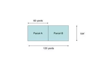
Parcel Types Overlapping Parcels All Subdivisions, Lots, Tax Parcels, etc. are “Parcels” in the Parcel Fabric Migrating Parcel data to the Local Government Information Model
Migrating Data to a Parcel Fabric • Load topology geoprocessing tool • Loads a clean, validated topology into a parcel fabric • Line feature class, polygon feature class • Topology is validated against a required set of rules • Import control points wizard • Loads control from a feature class, table or .csv file Migrating Parcel data to the Local Government Information Model
Demo Loading data into a Parcel Fabric Migrating Parcel data to the Local Government Information Model
What is the Local Government Information Model? LGIM – Local Government Information Model • Collection of GIS dataset models, web services, maps & apps • Organizes information and processes across departments • Parcel Fabric Solution is a part of the LGIM Migrating Parcel data to the Local Government Information Model
What is the Local Government Information Model? LGIM – Parcel Editing uses a Parcel Fabric • Uses a parcel fabric for parcel editing & maintenance • Parcel data is migrated to a parcel fabric • 10.1 SP1: Create/upgrade a parcel fabric to LGIM with a button click Migrating Parcel data to the Local Government Information Model
Parcel Editing in the LGIM Tax Parcel Editing Map • Built with three components of COTS technology: • A Parcel Fabric Information Model (Info) • A Tax Parcel Editing Map designed for editing workflows • Workflow dialog with specific, goal-driven tasks Editing & Maintaining Parcels with ArcGIS
Parcel Editing in the LGIM Parcel fabric layer and additional layers for parcel types One parcel fabric, Many parcel types Migrating Parcel data to the Local Government Information Model
Parcel Editing in the LGIM Parcel types and domains • Some parcel type layers have attribute domains • Layers symbolized using attribute domains Migrating Parcel data to the Local Government Information Model
Data Loading Phases Source > Staging > Loading Geodatabase \ Coverages Staging Geodatabase Loading Production Files: CAD, SHP Parcel Fabric Simple Feature Classes & Topology Tables with XY for Control, CAMA Data Cleanup Migrating Parcel data to the Local Government Information Model
Resources for Data Migration Data Migration • GP Tool: Parcel Fabric Data Migration and Analysis Tools • GP Tool: Iteratively Load to the Parcel Fabric • Staging Data: Tax Parcel Editing Fabric Original Sources Staging Loading Production Parcel Fabric Simple Feature Classes & Topology
Resources for Data Migration Data Migration • Whitepaper • Loading Data Into a Parcel Fabric • ArcGIS Help 10.2 • Migrating data to the Parcel Fabric Migrating Parcel data to the Local Government Information Model
Most of the work is done in staging To avoid topology errors: create polygons from lines or vice versa • Use a schema only layer package (part of the Tax Parcel Editing download) • Calculate types on source parcel data • Load & Create polygons and lines for each parcel type • For each type validate and fix topology errors • Use the Load Topology geoprocessing tool to migrate data Migrating Parcel data to the Local Government Information Model
Data Cleanup • Fix Geometry before attributes • Polygon to lines (or vice versa) • Clean and format curves • Check COGO dimensions on lines (if exist) • Check and repair geometries • Create and Validate topologies, fix errors Migrating Parcel data to the Local Government Information Model
Resource for Data Cleanup Helper Add-in: Curves And Lines • Use Desktop Search to Find Add-ins for fabrics
Loading data using Topology • Load Topology Geoprocessing tool • Load topologies to the parcel fabric in the ParcelEditing feature dataset • Log file • Import Control points Migrating Parcel data to the Local Government Information Model
Demo Staging Environment Data Cleanup Loading to LGIM Migrating Parcel data to the Local Government Information Model
Data migration Tips and Tricks Migrating Parcel data to the Local Government Information Model
Community Resources and Participation • New Instructor-Lead Training • (http://bit.ly/1btCtdB) • New 10.2 Resource Center for Land Records (http://bit.ly/15bV3qA) • Community Participation: Meet-up, Forum, Ideas Editing & Maintaining Parcels with ArcGIS
Community Meet-up • Meet-up : http://www.meetup.com/Esri-Land-Records-Meet-Up/ • Bi-weekly Virtual Meet-up: • Live Demos • Interactive Discussion in the Community • Your Ideas • Your Support Incidents
Community Ideas • Ideas : http://ideas.arcgis.com/
Community Forum • Forum : http://forums.arcgis.com/forums/44-Land-Records
Additional offerings • Editing and Maintaining Parcels with ArcGIS • Thu 7/11/2013, 10:15 AM - 11:30 AM, Room 10 • ArcGIS Deed Drafter: An Introduction • Thu 7/11/2013, 11:30 AM - 12:00 PM, Hall H - GIS Discussion Lounge Migrating Parcel data to the Local Government Information Model
Thank you… Please fill out the session evaluation Offering ID: 1383 Online – www.esri.com/ucsessionsurveys Paper – pick up and put in drop box Migrating Parcel data to the Local Government Information Model
Migrating Parcel data to the Local Government Information Model