Download
1 / 21
210 likes | 345 Views
GEWEX And Observational Networks. Peter van Oevelen Kevin Trenberth Dawn Erlich. General Info. Website: http://www.gewex.org Organizational Structure: Scientific Steering Group Four Scientific Panels WCRP Joint Scientific Committee is oversight body. J. Polcher.

E N D
GEWEX And Observational Networks Peter van Oevelen Kevin Trenberth Dawn Erlich
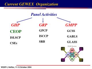
General Info • Website: http://www.gewex.org • Organizational Structure: • Scientific Steering Group • Four Scientific Panels • WCRP Joint Scientific Committee is oversight body
Some Key Issues for GEWEX • The new GEWEX has adopted the mission of “land-atmosphere” • However GEWEX has also decided to be much more: • GEWEX will continue to embrace the global energy and water cycles • GEWEX also embraces activities spanning Earth system domains and other integrating themes • monsoons • extremes …
GEWEX : post 2013 New name*: Global and regional Energy and Water Existentialism: GEWEX Exchanges: GEWEX * To be approved
GEWEX: post 2013 Mission statement To measure and predict global and regional energy and water variations, trends, and extremes (such as heat waves, floods and droughts), through improved observations and modeling of land, atmosphere and their interactions; thereby providing the scientific underpinnings of climate services. To measure and predict global and regional energy and water variations, trends, and extremes(such as heat waves, floods and droughts), through improved observations and modeling of land, atmosphere and their interactions; thereby providing the scientific underpinnings of climate services.
Imperatives: Headlines Datasets: Foster development of climate data records of atmosphere, water, land, and energy-related quantities, including metadata and uncertainty estimates. Analysis:Describe and analyze observed variations, trends and extremes (such as heat waves, floods and droughts) in water and energy-related quantities. Processes: Develop approaches to improve process-level understanding of energy and water cycles in support of improved land and atmosphere models. Modeling:Improve global and regional simulations and predictions of precipitation, clouds, and land hydrology, and thus the entire climate system, through accelerated development of models of the land and atmosphere. Applications:Attribute causes of variability, trends and extremes, and determine the predictability of energy and water cycles on global and regional bases in collaboration with the wider WCRP community. Technology transfer:Develop diagnostic tools and methods, new observations, models, data management, and other research products for multiple uses and transition to operational applications in partnership with climate and hydro-meteorological service providers. Capacity building:Promote and foster capacity building through training of scientists and outreach to the user community.
Example: Imperatives: 1 DATASETS: Foster development of climate data records of atmosphere, water, land, and energy-related quantities, including metadata and uncertainty estimates. Lead: GRP, CEOP; Partners: SCOPE-CM, CEOS, WOAP Actions: • Reprocess GEWEX datasets, provide advice on other efforts and lead evaluations. • Continue evaluation and refinement of sensor algorithms, influencing next generation space-born platforms and reprocessing. • Development of appropriate calibration/validation/evaluation datasets to confront models. • Devise robust ways of dealing with the more diverse, complex, higher spatial and temporal resolution, and much greater volumes of data. • Build on CEOP experience in data management, archival and access.
GRP develops climate data recordsof water and energy variables, complete with metadata and error bars. Clouds - ISCCP Cloud Assessment Radiation - SRB Surface reference observations - BSRN Radiation Assessment Aerosols - GACP Aerosol Assessment Precipitation - GPCP Sfc gauge obs(GPCC) Turbulent Fluxes SeaFlux LandFLux - Soil Moisture Pentad Available Global Datasets Daily 3 – 6 hrs TIME 1979 1985 1990 1995 2000 2005 2010 Parameter Clouds Water Vapor 50 km Precipitation 250 km 100 km TOA Radiation 100 km SRF Radiation 100 km 50 km Evaporation Atmospheric Circulation 50 km A GRP product is endorsed by GEWEX/GRP to conform to a high standard of production and documentation. It consists of a blend of available satellite and in-situ observations and is periodically compared and assessed against other products in an open and transparent fashion. It is openly available to everyone without restrictions.
Key Data Objective When GRP began there were few datasets. Now there is a proliferation: a multitude of datasets that are all different, and with different strengths and weaknesses. The need to assess these, and evaluate and reprocess the data is enormous! So the objective is: Reprocess all GRP products with common ancillary data and assumptions. Panel has learned much about reprocessing; distribution; documentation and user support. Plan to reprocess periodically (e.g. approx. every 5 years) Publish state of the “Observed” Water and Energy budgets Expand accessibility to multi-variable products Facilitate research to interpret global and regional covariance among Water & Energy variables. Assess all products of the same variable for strengths and weaknesses.Each agency wants to only reprocess their product. Help move products to operations; share experience
2. Analysis:Describe and analyze observed variations, trends and extremes (such as heat waves, floods and droughts) in water and energy-related quantities. Precipitation from observations and reanalyses (courtesy D. Dee) Runoff trends 1948 to 2004 (Dai et al 2009)
CEOP GHP Terrestrial Regional North American Hydroclimate Experiment (TRACE) Regional water cycles
GHP 3 -5 Year Vision • Promotes evolution of Regional Hydroclimate Projects: • biological/environmental aspects • anthropogenic climate focus , • longer term, exploiting the infrastructures of the RHPs. • Seeks to enhance integration of in-situ, satellite and model data. • Includes e.g Monsoons Regional Study and Pan-WCRP Monsoon crosscut on • regional studies in cold regions, • high elevations, • monsoon, and • semi-arid regions. • Focus on Water and Energy budgets, 2002 out to 2013 and beyond. • extremes • aerosols • water isotopes • Hydrologic Applications Project (HAP): explicit global, regional, land surface, and hydrologic applications; cooperating with Hydrologic Ensemble Prediction Experiment (HEPEX).
http://www.eol.ucar.edu/ projects/ceop/dm/ INTEGRATED IN-SITU SATELLITE MODEL
RoleofHE Mountains occupy 24% of the global land surface covering all altitudinal belts and encompassing within them all the Earth’s climatic zones (Meybeck et al., 2001). High elevation areas (above 2,500 m a.s.l.) represent about 20% of the total mountain area (not counting Antarctica). http://www.unep-wcmc.org/habitats/mountains/region.html
Objectives Goal:to study multi-scale variability in hydro-meteorological and energy cycles in high elevation areas, while improving observation, modeling and data management. Objectives: • - promote a network of monitoring of climatic data in high elevation regions, • - develop a database and a mechanism for sharing the data collected at high elevation monitoring stations, • - improve the studies on energy and water budgetat high altitude to optimize the benefits in water resources management, • - improve understanding of the influence of aerosolsand other atmospheric components on the water cycle in high elevation areas.
645 Recent updates Permanent monitoring sites distribution in the HE Total Stations > 2500 m a.s.l.: Objective: to create a global network based on 30-40 sites and to increase up to 10-12 the number of reference sites.
7. Capacity Building: Promote and foster the development of capacity throughtraining of scientists and outreach to the user community. Education: workshops, training, summer schools; observations, data; technology use; technology transfer; interactions with users; outreach climate services. Participants at a recent La Plata Basin Workshop held in Itaipú Technological Park, Foz do Iguaçu, Paraná State, Brazil. A panel discussion at the International BACC Conference, May 2006 in Gothenburg, Sweden, providing for science – stakeholder interaction and GEWEX/BALTEX outreach.
Some Concluding Thoughts/Ideas • Himalayan Hydromet Stations Extremely Important • Data quality and consistency as important as quantity • High Altitude data/science should be more linked to High Latitude data/science • GEWEX High Elevation working group (G. Tartari) natural and obvious link • TPE could consider becoming a GEWEX RHP • Wealth of experience in measurement networks and data set development exists – do not invent the wheel again!